WSRC-TR-2003-00106
Sampling and Analysis Plan for Investigating the
Origin of Natural 226Ra, 228Ra, and 238U
in
South Carolina Coastal Plain Groundwater
Margaret R. Millings, Jay Noonkester, and Miles E. Denham
Westinghouse Savannah River Company
Aiken, SC 29808
1.0 Introduction
The aquifers of the South Carolina Coastal Plain are relatively enriched in natural radioactivity, yet there are few systematic studies of background concentrations and the origin of naturally occurring radionuclides in local groundwater. Periodically, public supply wells in Perry, Silver Springs and nearby Jackson, SC, exhibit elevated radium concentrations. Moreover, the recent discovery of high uranium concentration in residential wells in the upstate of South Carolina has generated further interest within South Carolinas Department of Health and Environmental Control in understanding the origin of elevated radioactivity in groundwater throughout the state.
Most previous studies have relied on sampling residential drinking water wells or city water supply wells. The P-well clusters at Savannah River Site (SRS) provide an excellent opportunity for assessing 226Ra, 228Ra, and 238U concentrations in groundwater using wells of similar construction with accurately defined screen zones that sample each of the major aquifers. In addition, the sediment cores taken during construction of the P-wells are available for sampling and may allow correlation of the sediment mineralogy and chemistry with concentrations of natural radionuclides in groundwater. The availability of sediment core over a large area from principal aquifers is unique to the SRS and may provide a basis for understanding elevated concentrations of 226Ra, 228Ra, and 238U in Coastal Plain groundwater.
2.0 Objectives
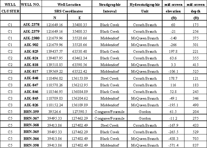
The objective of this investigation is to obtain baseline data for naturally occurring Ra and U from the water table, Gordon, Crouch Branch, and McQueen Branch Aquifers, which provide drinking water for private and city supply wells in the region. Background wells onsite (P-wells) and nearby offsite wells (C-Wells) will be sampled in this study. Wells that may be sampled are shown on Figure 1 and listed on Table 1 and 2.
The P-Wells were installed at SRS in the late 1980s as part of the SRP Baseline Hydrogeological Investigation for the purpose of updating and improving the current knowledge and understanding of the hydrogeological systems underlying the SRS (Bledsoe 1984; Bledsoe 1987; Bledsoe 1988). Wells are screened in all identified aquifer systems and archived core for most of the P-Wells is available for sampling. The C-Wells were installed by South Carolinas Department of Natural Resources (SCDNR) as part of the Lower Savannah River Project to better understand the hydrogeologic conditions in west-central South Carolina. These wells fringe the SRS and are also screened in identified aquifer systems.
3.0 Sampling Plan
Each well will be sampled once and analyzed for 226Ra, 228Ra, and 238U. Samples will also be collected for elemental analysis by inductively coupled plasma emission spectroscopy (ICP-ES) and for anion analysis by ion chromatography (IC). Before sampling, each well will be purged in excess of two well volumes, and field parameters (pH, conductivity, temperature, oxygen reduction potential, dissolved oxygen and turbidity) will be recorded in five-minute intervals to confirm stabilization. Samples collected will be filtered using in-line 0.45 micron filters. For a set of 5 samples, which will be chosen based on gross alpha measurements reported in Strom and Kaback (1992), unfiltered samples will also be analyzed. A YSI Series 6 Water Quality Logging system will be used to measure the water quality parameters. A flow through cell will be used to create a closed system for water quality measurements. A DRT-15 turbidimeter will be used to measure turbidity. In addition, one duplicate sample will be collected and analyzed.
Based on the radiological results of the groundwater samples, sediment samples will be collected from P-Well core either near or at the same depths as the screen zones. Potential analyses of the sediments include: x-ray fluorescence and petrographic microscopy to determine overall chemistries and mineralogy of the core; heavy mineral separation to separate mineral grains; x-ray diffraction and/or scanning electron microscopy to analyze the mineralogy and chemistry of separate grains; and fission track mapping to analyze minerals containing uranium. Comparisons among wells of water chemistries, sediment mineralogy and chemistries, and geophysical logs will be completed to try to determine origins of the natural radioactivity and provide information regarding potential methods of predicting areas that may have a higher occurrence or concentration of natural radionuclides.
4.0 Sample and Field Data Management
This project is a non-baseline scoping activity and will be conducted under Savannah River Technology Center (SRTC) Conduct of Research and Development. Operation and calibration of field instruments will follow Manual L14.1 Environmental Science Section Procedures (U), Procedures 2-141 and 2-131. Sampling protocols and procedures (including chain-of-custody) in addition to shipping, handling, and holding requirements are provided in the WSRC Hydrogeologic Data Collection Procedures (U) (WSRC 1997). The technical oversight will act as the health and safety officer during fieldwork. SRTC will provide radiological, elemental, and anion analyses of all groundwater samples and perform analyses of sediment samples.
A chain-of-custody (COC) record shall be maintained to document the possession of collected groundwater samples from the time they are obtained until received by contract laboratory personnel.
The record will consist of the following information:
- Project name and number
- Signature of sampler(s)
- Sample identification number
- Sampling date and time
- Sample type
- Number of containers per sample
- Remarks or comments
- Signature of the person relinquishing the sample and the person receiving the sample
- Date and time the transfer occurred
An original COC form will accompany each shipment. The original COC record will be returned to the Project Manager after the laboratory receives samples. Custody will be maintained for all sample containers and shipping containers. Field notes will be recorded in a WSRC controlled logbook. The following data will be recorded in the field notebook at each sample location: date and time, water level, total amount purged, sample ID, comments/observations and water quality parameters.
5.0 Waste Disposition
The P-Wells were installed as background wells and are located along the perimeter of the SRS and near SRS facilities. The P-well clusters located near facilities were all placed upgradient of known contaminant sources. No contaminants have been detected in the wells listed in this sampling and analysis plan (Strom and Kaback 1992). Consequently, no containerization will be required and the purge water will be returned to the ground. Disposition of water from the C-Wells will be determined by SCDNR.
6.0 References
- Bledsoe, H. W., 1984. SRP Baseline Hydrogeologic Investigation Phase I, DPST-84-833, E. I. du Pont de Nemours & Company, Savannah River Laboratory, Aiken, SC.
- Bledsoe, H. W., 1987. SRP Baseline Hydrogeologic Investigation Phase II, DPST-86-674, E. I. du Pont de Nemours & Company, Savannah River Laboratory, Aiken, SC.
- Bledsoe, H. W., 1988. SRP Baseline Hydrogeologic Investigation Phase III, DPST-88-627, E. I. du Pont de Nemours & Company, Savannah River Laboratory, Aiken, SC.
- Gellici, J. A., and Gawne, C. E., 1996. Hydrogeologic Investigation and Establishment of a Permanent Multi-Observational Well Network in Aiken, Allendale, and Barnwell Counties, South Carolina Phase VIII, South Carolina Department of Natural Resources, Water Resources Division, Open-File Report 3.
- Strom, R. N., and Kaback, D. S., 1992. SRP Baseline Hydrogeologic Investigation: Aquifer Characterization, Groundwater Geochemistry of the Savannah River Site and Vicinity (U), WSRC-RP-92-450, Westinghouse Savannah River Company, Savannah River Laboratory, Aiken, SC.
- WSRC, 1997. WSRC Hydrogeologic Data Collection Procedures (U), Manual 3Q5, Rev. 2, Westinghouse Savannah River Company, Savannah River Site, Aiken, SC.
- WSRC, Environmental Science Section Operating Procedures (U), Manual L14.1, Westinghouse Savannah River Company, Savannah River Technology Center, Aiken, SC.
- WSRC, 2000. Conduct of Research & Development Savannah River Technology Center (U) Rev. 2, WSRC-IM-97-00024, Westinghouse Savannah River Company, Savannah River Technology Center, Aiken, SC
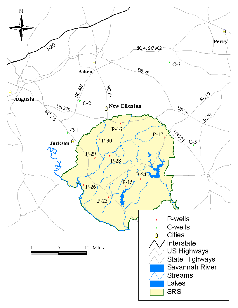
Figure 1 Location of P-Wells and C-Wells
Table 1 P-Well Information
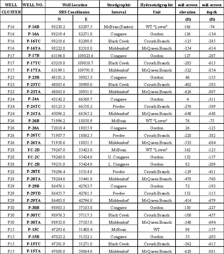
Table 2 C-Well Information