This report was prepared as an account of work sponsored by an agency of the United States Government. Neither the United States Government nor any agency thereof, nor any of their employees, makes any warranty, express or implied, or assumes any legal liability or responsibility for the accuracy, completeness, or usefulness of any information, apparatus, product or process disclosed, or represents that its use would not infringe privately owned rights. Reference herein to any specific commercial product, process or service by trade name, trademark, manufacturer, or otherwise does not necessarily constitute or imply its endorsement, recommendation, or favoring by the United States Government or any agency thereof. The views and opinions of authors expressed herein do not necessarily state or reflect those of the United States Government or any agency thereof.
This report has been reproduced directly from the best available copy.
Available to DOE and DOE Contractors from the Office of Scientific and Technical Information, P. O. Box 62 Oak Ridge, TN 37831; prices available from (423) 576-8401.
Available to the public from the National Technical Information Service, U.S. Department of Commerce, 5285 Port Royal Road, Springfield, VA 22161.
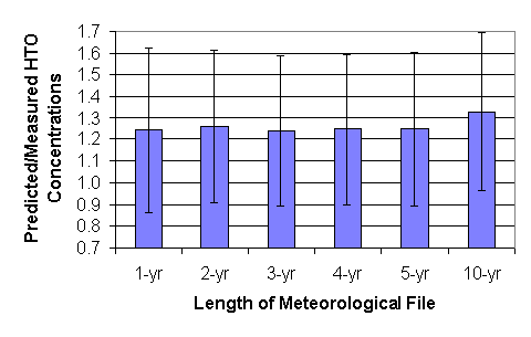
Measured tritium oxide concentrations in air have been compared with calculated values using routine release Gaussian plume models for different time intervals of meteorological data. These comparisons determined an optimum time interval of meteorological data used with atmospheric dose models at the Savannah River Site (SRS). Meteorological data of varying time intervals (1-yr to 10-yr) were used for the comparison. Insignificant differences are seen in using a one-year database as opposed to a five-year database. Use of a ten-year database results in slightly more conservative results. For meteorological databases of length one to five years the mean ratio of predicted to measured tritium oxide concentrations is approximately 1.25 whereas for the ten-year meteorological database the ratio is closer to 1.35. Currently at the Savannah River Site a meteorological database of five years duration is used for all dose models. This study suggests no substantially improved accuracy using meteorological files of shorter or longer time intervals.
Key Words: tritium, air sampling, meteorology, computer calculation
Radiation doses are calculated at the Savannah River Site (SRS) for routine and accidental releases using several site-specific computer models. Comparisons of predicted versus measured atmospheric tritium oxide concentrations have been performed with favorable results (Simpkins and Hamby 1997) yielding mean ratios of predicted-to-measured concentrations ranging from 1.4 to 1.9 for the various models.
For each of the codes, downwind concentrations, and therefore dose, are calculated using a meteorological joint frequency distribution (JFD) of wind speed and atmospheric stability as a function of wind direction. Traditionally, five-year JFD�s have been used at the SRS. Little regulatory guidance exists for determining the appropriate length of record for a JFD used for dose calculations. For facility siting purposes U.S. Nuclear Regulatory Commission (NRC) Safety Guide 1.23 states, "The minimum amount of meteorological data needed for siting evaluation is considered to be that amount of data gathered on a continuous basis for a representative consecutive 12 month period. Two full annual cycles of data are desirable." To determine an appropriate length of record for a JFD at the SRS, actual atmospheric tritium oxide concentrations were compared to modeled values using one, two, three, four, five and ten-year JFD�s.
The routine release atmospheric dose model MAXIGASP (Bauer 1991 and Hamby 1992a), was used for the comparison with measured concentrations. MAXIGASP is based on U.S. NRC Regulatory Guides 1.109 and 1.111 (USNRC 1977a and 1977b) and is a combination of two algorithms: XOQDOQ and GASPAR. XOQDOQ (Sagendorf et al. 1982) predicts the downwind relative air concentrations based on a given set of input parameters. GASPAR (Eckerman et al. 1980) utilizes the output from XOQDOQ to predict doses for a variety of exposure pathways. At SRS, MAXIGASP is used primarily to predict doses to the maximally exposed offsite individual for the annual Environmental Report and various Environmental Impact Statements. MAXIGASP contains site-specific land usage parameters (Hamby 1992b) and uses a five-year meteorological joint frequency distribution.
Meteorological monitoring at SRS is conducted at eight 61-m towers in locations near the highest potential sources of atmospheric effluents. The 61-m height corresponds to the stack height of most nearby facilities. For this comparison all releases are assumed to originate from the center of the site and the H Area meteorological tower data is used. Towers are situated above relatively undisturbed forest since SRS is primarily covered by forest.
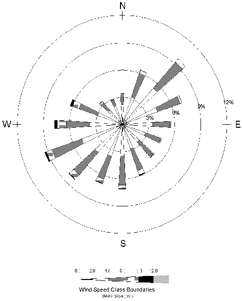
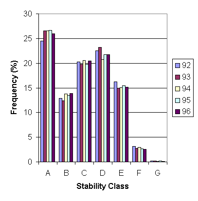
The Met One Model 1585 bivane is used to measure horizontal and vertical wind direction at area towers. Measurements of turbulence are expressed as standard deviations of fluctuations about the mean azimuth and elevation angle. (Parker and Addis 1993) These turbulence measurements are then used to determine the Pasquill-Gifford (Gifford 1976) stability class. Fig. 1 shows a wind rose for H Area for the period 1992-1996.
The joint frequency distribution in MAXIGASP contains sixteen sectors, seven stability classes, and six wind speed categories. For use in MAXIGASP, the wind speed for each of the categories is assigned a constant value which corresponds to the midpoint of the wind speed classes. These assumed values are: 1.0, 3.0, 5.0, 7.0, 10.0, and 13.05 m/s. Since the percentage of time during the period that these conditions occur varies, average wind speed can vary for JFD�s of different lengths. Using the representative wind speeds and the frequencies of wind speed class for individual years 1992 through 1996, the wind speed average ranges from 3.9 to 4.0 m/s showing little variation from year to year. The average wind speed for the meteorological database containing all years from 1992 through 1996 and 1987 through 1996 was 4.0 m/s and 3.9 m/s, respectively.
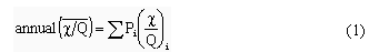
MAXIGASP predicts annual average relative concentrations by weighting each of the calculated concentrations (for all wind speed and stability classes) in accordance with the probability of occurrence using the following equation:
where
Pi = probability of a given set of meteorological conditions occurring
(c
Relative air concentrations averaged over a wind-direction sector are determined using the following equation:
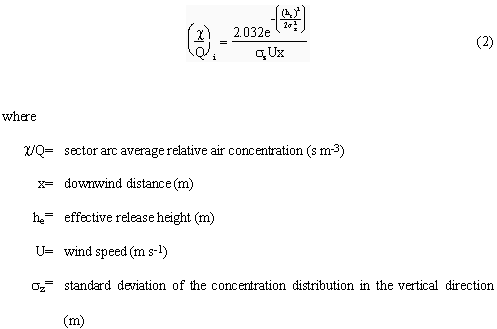
Pasquill-Briggs rural diffusion coefficients (Briggs 1973) were used to calculate the standard deviation of the concentration distribution in the horizontal and vertical directions.
Tritium oxide is sampled biweekly using silica gel which traps moisture from air pumped through a column. Water is removed from the silica gel by distilling over low heat. The distillate is mixed with a liquid scintillation cocktail, and counted to determine the tritium oxide concentration of the atmospheric moisture. Daily average atmospheric absolute humidity values were used to convert to tritium oxide concentration in air (Cummins, et al. 1991).
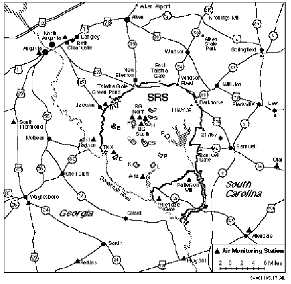
The tritium oxide concentrations in air at 13 perimeter locations were compared with predicted concentrations from MAXIGASP. The location of all of the collection points is shown in Fig. 2. The average distance from the center of the site to the each of the perimeter locations at the boundary is 14500 m. In Fig. 2, Reactor Areas are noted as C, K, L, and P and Separations Areas are noted as F and H. Release amounts for each of the years are shown in Table 1 which also shows a breakdown of percentage release from reactors and separations. Measured air concentrations at the various monitoring locations are shown in Table 2.
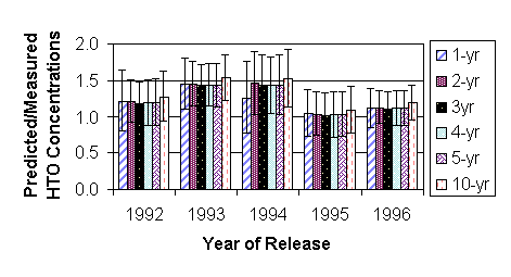
Measured tritium oxide concentrations were compared with those predicted by MAXIGASP using JFD�s of various time intervals. For the one-year comparisons the monitoring results for the year in question were compared with MAXIGASP results using the JFD for that year. For the two-year comparison, the JFD for 1995-1996 was used to calculate the air concentrations and then the results were compared with each of the individual years. For the three-year comparison the JFD for 1994-1996 was used etc. Fig. 3 shows the frequency of each stability class for each of the years. Since relatively little variation is seen, using the most recent years� data is appropriate. The relatively large frequency in the Class A stability category is due to correctly accounting for wind direction changes over one-hour periods (Parker, et al. 1992 and Laurinat 1987).
Predicted-to-measured tritium oxide concentration results are shown in Fig. 4 for releases occurring from 1992 to 1996. Error bars represent standard deviations of the data that was averaged. There is little difference from using the various lengths of JFD�s except for a slight increase when the 10-yr JFD is used. Meteorological data capture has greatly improved with instrumentation upgrades in the late 1980�s and is possibly the reason that concentrations calculated with the 10-yr JFD show a slight difference.
The variances from measurement year to year are likely due to environmental factors such as humidity. In 1995 the site went from using quarterly humidity values to biweekly humidity values, and this is likely the reason for greater agreement during the 1995-1996 time frame. In 1994 only one value was used for humidity for the entire year due to sampling problems.
Another reason for the variances from year to year is that release amounts vary by location and height but only one release point and height were used for the modeling. All releases were assumed to originate from 61 m above grade elevation at the center of the site even though releases of tritium oxide actually came from several different locations across the site. For each of the years, a majority of the releases came from 61 m at F and H Areas (See Fig. 2) which are near the center of the site. The remaining releases came from the reactor areas (C, K, L, and P Area). Table 1 shows the percentage release from F and H Areas as opposed to reactor areas. While releases are assumed to be continuous over the course of a year, this is not the case. The actual wind direction at the time of the release from a given facility also has an effect on the differences.
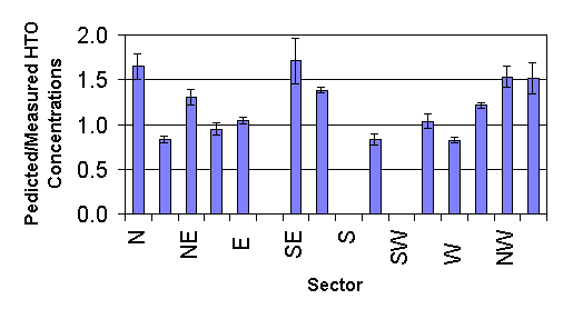
Fig. 5 shows predicted/measured tritium oxide concentrations for 1992 releases by sector. The predicted concentrations are calculated by averaging air concentrations calculated with each of the different lengths of JFD�s. Some sectors do not contain data because concentrations were not monitored. The standard deviation for individual sectors was very small (typically less than 0.1). There is a slight negative correlation between frequency for a given direction and predicted/measured tritium oxide concentration. However this is not true for all sectors.
Fig. 6 is a summary of Fig. 4. The predicted concentrations are averaged for all five years of monitoring data. The lack of fluctuation of mean ratios for each of the time intervals demonstrates that there is no real difference between using a one-year or a five-year JFD. The reason that using a ten-year JFD overestimates tritium concentrations more could be due to instrumentation upgrades or climatological changes that may occur over the longer time period.
For routine release dose calculational models used at SRS, predicted versus measured tritium oxide concentrations show little variance for JFD�s of length one to five years with only slightly greater variance for using a ten-year meteorological data base. Systematic differences occur for each year of release which indicates differences in the local climate rather than calculational model differences. Continuation of using a five-year meteorological data base at SRS is justified. Little, if any, improvement in predictive capabilities would be seen by using a different time interval of data and it is cost-effective to stay with the longer period of meteorological data.
The information contained in this document was developed during the course of work under contract number DE-AC09-96R18000 with the U.S. DOE.
|
Year |
Amount |
Released from |
Released from |
|
1992 |
3.70x10⁶ |
47 |
53 |
|
1993 |
4.92 x10⁶ |
29 |
71 |
|
1994 |
3.70 x10⁶ |
22 |
78 |
|
1995 |
2.04 x10⁶ |
24 |
76 |
|
1996 |
1.50 x10⁶ |
29 |
71 |
|
|
|
|
Air Concentration (Bq m-3) |
||||
|
1992a |
1993b |
1994c |
1995d |
1996e |
|||
|
N |
E Talatha Gate |
15977 |
0.88 |
1.09 |
0.99 |
0.56 |
0.37 |
|
NNE |
Windsor |
17825 |
1.14 |
0.97 |
1.03 |
0.67 |
0.41 |
|
NE |
Darkhorse |
17463 |
0.95 |
1.12 |
0.92 |
0.56 |
0.41 |
|
ENE |
Highway 21/167 |
16603 |
0.78 |
1.01 |
0.65 |
0.59 |
0.37 |
|
E |
Barnwell Gate |
14926 |
0.69 |
0.95 |
0.62 |
0.48 |
0.37 |
|
SE |
Patterson Mill |
15518 |
0.74 |
0.51 |
0.43 |
0.44 |
0.30 |
|
SSE |
Allendale Gate |
15322 |
0.61 |
0.34 |
0.50 |
0.44 |
0.26 |
|
SSW |
A-14 |
8658 |
1.31 |
1.40 |
0.73 |
0.59 |
0.48 |
|
WSW |
D Area |
10663 |
1.98 |
2.23 |
1.57 |
1.18 |
0.70 |
|
W |
W. Jackson |
13061 |
0.97 |
0.99 |
0.70 |
0.59 |
0.37 |
|
WNW |
Jackson |
15258 |
0.88 |
1.31 |
0.60 |
0.74 |
0.41 |
|
NW |
Green pond |
14484 |
0.87 |
1.17 |
0.80 |
0.63 |
0.41 |
|
NNW |
Talatha Gate |
14362 |
0.87 |
1.34 |
1.12 |
0.59 |
0.48 |
aArnett (1993).
bArnett (1994)
cArnett (1995)
dArnett (1996)
eArnett (1997)
|
Meteorological File Length with Years of Data Used |
|||||||||||
|
|
|
1-yr |
1-yr |
1-yr |
1-yr |
1-yr |
2-yr |
3-yr |
4-yr |
5-yr |
10-yr |
|
92 |
93 |
94 |
95 |
96 |
95-96 |
94-96 |
93-96 |
92-96 |
87-96 |
||
|
N |
E Talatha Gate |
3.4x10⁻⁷ |
4.7x10⁻⁷ |
4.1x10⁻⁷ |
3.5x10⁻⁷ |
3.8x10⁻⁷ |
3.7x10⁻⁷ |
3.8x10⁻⁷ |
4.0x10⁻⁷ |
3.9x10⁻⁷ |
4.4x10⁻⁷ |
|
NNE |
Windsor |
1.4x10⁻⁷ |
1.4x10⁻⁷ |
1.0x10⁻⁷ |
1.5x10⁻⁷ |
1.3x10⁻⁷ |
1.4x10⁻⁷ |
1.3x10⁻⁷ |
1.3x10⁻⁷ |
1.3x10⁻⁷ |
1.4x10⁻⁷ |
|
NE |
Darkhorse |
2.7x10⁻⁷ |
3.1x10⁻⁷ |
2.9x10⁻⁷ |
3.3x10⁻⁷ |
3.0x10⁻⁷ |
3.2x10⁻⁷ |
3.1x10⁻⁷ |
3.1x10⁻⁷ |
3.0x10⁻⁷ |
3.3x10⁻⁷ |
|
ENE |
Highway 21/167 |
2.6x10⁻⁷ |
3.0x10⁻⁷ |
3.5x10⁻⁷ |
2.7x10⁻⁷ |
3.0x10⁻⁷ |
2.9x10⁻⁷ |
3.1x10⁻⁷ |
3.0x10⁻⁷ |
3.0x10⁻⁷ |
3.1x10⁻⁷ |
|
E |
Barnwell Gate |
2.6x10⁻⁷ |
2.5x10⁻⁷ |
2.7x10⁻⁷ |
2.7x10⁻⁷ |
2.9x10⁻⁷ |
2.8x10⁻⁷ |
2.8x10⁻⁷ |
2.7x10⁻⁷ |
2.7x10⁻⁷ |
2.8x10⁻⁷ |
|
SE |
Patterson Mill |
4.7x10⁻⁷ |
3.4x10⁻⁷ |
3.3x10⁻⁷ |
3.0x10⁻⁷ |
3.5x10⁻⁷ |
3.2x10⁻⁷ |
3.3x10⁻⁷ |
3.3x10⁻⁷ |
3.6x10⁻⁷ |
3.5x10⁻⁷ |
|
SSE |
Allendale Gate |
4.8x10⁻⁷ |
4.4x10⁻⁷ |
4.8x10⁻⁷ |
5.8x10⁻⁷ |
4.4x10⁻⁷ |
5.1x10⁻⁷ |
5.0x10⁻⁷ |
4.9x10⁻⁷ |
4.8x10⁻⁷ |
5.0x10⁻⁷ |
|
SSW |
A-14 |
4.9x10⁻⁷ |
4.6x10⁻⁷ |
4.5x10⁻⁷ |
5.1x10⁻⁷ |
3.1x10⁻⁷ |
4.1x10⁻⁷ |
4.2x10⁻⁷ |
4.3x10⁻⁷ |
4.4x10⁻⁷ |
4.8x10⁻⁷ |
|
WSW |
D Area |
2.2x10⁻⁷ |
2.5x10⁻⁷ |
1.7x10⁻⁷ |
3.0x10⁻⁷ |
2.5x10⁻⁷ |
2.8x10⁻⁷ |
2.4x10⁻⁷ |
2.4x10⁻⁷ |
2.4x10⁻⁷ |
2.5x10⁻⁷ |
|
W |
W. Jackson |
1.7x10⁻⁷ |
1.5x10⁻⁷ |
1.5x10⁻⁷ |
1.8x10⁻⁷ |
1.6x10⁻⁷ |
1.7x10⁻⁷ |
1.6x10⁻⁷ |
1.6x10⁻⁷ |
1.6x10⁻⁷ |
1.7x10⁻⁷ |
|
WNW |
Jackson |
3.1x10⁻⁷ |
2.8x10⁻⁷ |
3.2x10⁻⁷ |
2.7x10⁻⁷ |
3.6x10⁻⁷ |
3.1x10⁻⁷ |
3.2x10⁻⁷ |
3.1x10⁻⁷ |
3.1x10⁻⁷ |
3.3x10⁻⁷ |
|
NW |
Green pond |
3.2x10⁻⁷ |
4.4x10⁻⁷ |
3.5x10⁻⁷ |
3.3x10⁻⁷ |
4.0x10⁻⁷ |
3.6x10⁻⁷ |
3.6x10⁻⁷ |
3.8x10⁻⁷ |
3.7x10⁻⁷ |
4.1x10⁻⁷ |
|
NNW |
Talatha Gate |
3.4x10⁻⁷ |
2.4x10⁻⁷ |
2.1x10⁻⁷ |
2.8x10⁻⁷ |
2.7x10⁻⁷ |
2.8x10⁻⁷ |
2.6x10⁻⁷ |
2.5x10⁻⁷ |
2.7x10⁻⁷ |
2.9x10⁻⁷ |