WSRC-TR-2000-00310
Comparison of Cenozoic Faulting at the Savannah
River Site to Fault Characteristics of the Atlantic Coast Fault Province: Implications for Fault Capability
R.J. Cumbest, D.E. Wyatt, D.E. Stephenson, and M.Maryak
Westinghouse Savannah River Company
Aiken, SC 29808
This document was prepared in conjunction with work accomplished
under Contract No. DE-AC09-96SR18500 with the U.S. Department of Energy.
DISCLAIMER
This report was prepared as an account of work
sponsored by an agency of the United States Government. Neither the United States
Government nor any agency thereof, nor any of their employees, makes any warranty,
express or implied, or assumes any legal liability or responsibility for the
accuracy, completeness, or usefulness of any information, apparatus, product
or process disclosed, or represents that its use would not infringe privately
owned rights. Reference herein to any specific commercial product, process or
service by trade name, trademark, manufacturer, or otherwise does not necessarily
constitute or imply its endorsement, recommendation, or favoring by the United
States Government or any agency thereof. The views and opinions of authors expressed
herein do not necessarily state or reflect those of the United States Government
or any agency thereof.
This report has been reproduced directly from
the best available copy.
Available for sale to the public, in paper, from:
U.S. Department of Commerce, National Technical Information Service, 5285
Port Royal Road, Springfield, VA 22161, phone: (800) 553-6847, fax:
(703) 605-6900, email: orders@ntis.fedworld.gov online
ordering: http://www.ntis.gov/support/ordering.htm
Available electronically at http://www.osti.gov/bridge/
Available for a processing fee to U.S. Department
of Energy and its contractors, in paper, from: U.S. Department of Energy, Office
of Scientific and Technical Information, P.O. Box 62, Oak Ridge, TN 37831-0062,
phone: (865 ) 576-8401, fax: (865) 576-5728, email: reports@adonis.osti.gov
Executive Summary
Cretaceous to Tertiary faults along the Atlantic margin exhibit several general
characteristics that allow these faults to be grouped into the Atlantic Coastal
Fault Province (Prowell,1989). These characteristics include:
- Northeast – Southwest strike orientations for the first
order faults, with mainly reverse sense of motion
- relatively small amounts of offset in relation to their
age,
- movement histories that started in the Cretaceous and,
- offsets that become less at younger ages.
These shared characteristics indicate that these structures are genetically
related (that is resulted from the same tectonic process or processes).
Several faults in the Atlantic Coastal Province have been the subject of
detailed investigations by regulatory bodies in order to evaluate their
potential for seismic hazard. In all cases, the conclusion has been reached
that these faults are not capable in terms of Appendix A 10 CFR 100, (USNRC,
1973) 10 CFR 100.23 (USNRC, 1996). These studies and their conclusions form
a historical precedent that by the "association clause" in Appendix
A 10 CFR 100, (USNRC, 1973) 10 CFR 100.23 (USNRC, 1996) may be applied to
all faults included in the Atlantic Coastal Fault Province.
This study compares the faulting observed on the Savannah River Site and
vicinity with the faults of the Atlantic Coastal Fault Province and concludes
that both sets of faults exhibit the same general characteristics and are
closely associated. Based on the strength of this association it is concluded
that the faults observed on the Savannah River Site and vicinity are in
fact part of the Atlantic Coastal Fault Province. Inclusion in this group
means that the historical precedent established by decades of previous studies
on the seismic hazard potential for the Atlantic Coastal Fault Province
is relevant to faulting at the Savannah River Site. That is, since these
faults are genetically related the conclusion of "not capable"
reached in past evaluations applies.
In addition, this study establishes a set of criteria by which individual
faults may be evaluated in order to asses their inclusion in the Atlantic
Coast Fault Province and the related association of the "not capable"
conclusion. These criteria are based on orientation and offset history and
are:
- Maximum offset magnitude less than 80 meters (260
ft.) at the base of the Coastal Plain Sediments.
- For first order, regional scale features strike orientations
in the Northeastern – Southwestern quadrant with mainly reverse sense of
motion.
- Movement beginning in the Cretaceous and decreasing with
time.
All previously recognized faulting on Savannah River Site and vicinity
meet these criteria. Furthermore, in consideration of the large amount of
seismic reflection and borehole data that exists on the Savannah River Site
it is unlikely that unrecognized faults exist that do not meet these criteria.
Introduction and Scope
The Savannah River Site is located on the Coastal Plain of South Carolina
along the North American Atlantic Margin. The rocks and sediments that underlie
this region have a long and complicated tectonic history with major structural
elements resulting from Appalachian mountain building and opening of the
Atlantic Ocean basin. However, since the continental rifting process completed
about 200 million years ago the Atlantic margin has been conventionally
regarded as a tectonically stable trailing edge of the North American continent,
as it drifts away from Africa, due to continued opening of the Atlantic
basin.
The tectonic stability of the North American Atlantic margin is evidenced
by the relatively undisturbed Coastal Plain sedimentary sequences that overly
the crystalline rocks and sediments that were formed as a result of previous
extensive mountain building and rifting tectonism. The Coastal Plain sediments
form a relatively flat lying, oceanward thickening wedge of material with
the earliest units deposited in the Cretaceous (about 120 million years
ago). Due to their relatively undisturbed nature, Coastal Plain strata along
with their contact with the underlying, older, highly deformed units make
easily recognized strain markers that record any relative displacements
that may result from Cretaceous and later tectonic activity. The relative
lack of deformed markers in Coastal Plain sedimentary units lead to the
conventional wisdom in the geologic community up until about the 1970's
that no Cretaceous or Cenozoic aged faulting had occurred in this region.
Although some geologists had recognized Cretaceous and younger faulting
in the region for sometime before the 1970's, these features were not widely
recognized and acknowledged until the US Geological Survey made detailed
studies and provided extensive documentation of their characteristics as
part of their Reactor Hazards Program.
The lack of widespread recognition of the existence of Cretaceous and Cenozoic
faulting of the Atlantic Margin earlier on in the geologic community, was
probably the result of the relatively small magnitude of displacements recorded
by these features. Also, a consequence of their movement history, which
results in extremely small displacements in the youngest and most easily
observed sedimentary units, made their recognition at the surface difficult.
The largest offsets observed for these faults are on the order of 80 meters
(260 ft). However, for workers interested in the existence and character
of Cretaceous and Cenozoic tectonism of the Atlantic margin, these features
are highly significant in that they are the only record that exists, in
conjunction with broad scale modified depositional patterns and arching
of the Coastal Plain sediments, for this tectonism. The Atlantic Margin
as a whole exhibits relatively low levels of both historic and prehistoric
seismic activity (Amick and Gelinas, 1991). However, localized regions of
increased activity, seisomogenic zones, occur and the obvious question arises
as to the possible association of this relatively young faulting to historic
or prehistoric seismic activity.
Prowell (1988) notes that Cretaceous and Cenozoic faulting, along the North
American Atlantic Margin and Gulf Coast, occurs in three geographic provinces
that can be distinguished based on the characteristics exhibited by the
faulting (Figure 1). The Savannah River Site occurs near the southwestern
end of the Atlantic Coast Province. Although this region covers a large
area, the Cretaceous to Cenozoic faults in this region show remarkable similarities
in their orientations, movement sense, and movement histories. Several of
these faults have been the subject of detailed study so that their characteristics
are well documented. In addition, due to questions concerning their potential
for seismic hazard, several of these faults have also been evaluated in
association with construction of nuclear and other critical facilities (USNRC,
unpublished manuscript). In all cases, where detailed investigations have
been done these faults have been declared "not capable" as defined
by Appendix A 10 CFR 100, (USNRC, 1973) 10 CFR 100.23 (USNRC, 1996). In
this context, the term "capable fault" as defined in Appendix
A 10 CFR 100, (USNRC, 1973) 10 CFR 100.23 (USNRC, 1996) would apply to "a
fault that exhibited one or more of the following characteristics:
- Movement at or near the ground surface at least
once within the past 35, 000 years or movement of a recurring nature within
the past 500, 000 years.
- Macro-seismicity instrumentally determined with records
of sufficient precision to demonstrate a direct relationship with the fault.
- A structural relationship to a capable fault according
to characteristics (1) or (2) of this paragraph such that movement on one
could be reasonably expected to be accompanied by movement on another."
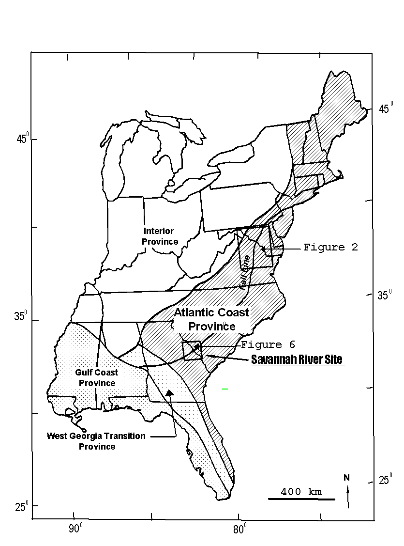
Figure 1. Map of the eastern United States showing Cretaceous
and Cenozoic fault provinces defined by fault characteristics (adapted from
Prowell, 1988).
The Savannah River Site has been extensively characterized as a result
of several geologic and geophysical studies that have been focussed on determining
the existence and extent of both surface and subsurface faulting (Seismograph
Service Corporation, 1971;Chapman and DiStefano, 1989; Anderson, 1990; Stephenson
and Stieve, 1992; Cumbest and others, 1992; Domoracki, 1995; Bartholomew
and others, 1997; Cumbest and others, 1998) As a result of these studies
several faults have been identified and mapped in the subsurface and extensive
evaluations concerning the seismic hazards associated with these features
undertaken. (Stieve, 1991; Stieve and others, 1991,Geomatrix, 1993; Stieve
and others, 1994; SAIC, 1996). These studies have all reached the same conclusion;
that no evidence is found of a "capable" fault on Savannah River
Site or in the vicinity. This conclusion is entirely consistent with the
fact that no seismicity has been associated with any faults on the Savannah
River Site. However, these evaluations are usually highly focussed on an
individual fault or fault segment. The approach in these studies is usually
to determine the age of the youngest deformed strata and thus evaluate the
movement history in the context of item (1) of Appendix A 10 CFR 100, (USNRC,
1973) 10 CFR 100.23 (USNRC, 1996) as stated above. However, several factors
make the determination of the youngest age for faults in the Coastal Plain
problematic. The relatively small offsets at shallow levels exhibited by
even the largest of these faults in conjunction with the poorly consolidated
nature of the sediments makes the determination of near surface deformation
difficult. Also, the fluvial nature of the shallow subsurface sediments
results in poor lateral continuity in these units and complicates the resolution
of structural disruption at shallow levels. Even if near surface structural
deformation is established the ages of the near surface and surface sediments,
except in very localized areas is on the order of 16 to 25 million years
at the Savannah River Site.. When considered relative to the age criteria
stated in Appendix A 10 CFR 100, (USNRC, 1973) 10 CFR 100.23 (USNRC, 1996)
as stated in item (1) above, the difficulty of this approach is evident.
This fact has been recognized by the Nuclear Regulatory Commission and others,
"In the Central and Eastern United States characterization of seismic
sources is more problematic than in the active plate margin region because
there is generally no clear association between seismicity and known tectonic
structures or near surface geology. In general, the observed geologic structures
were generated in response to tectonic forces that no longer exist and have
little or no correlation with current tectonic forces." (NRC Regulatory
Guide 1.165).
Previous studies rarely place the structures under consideration in the
context of other Atlantic Margin features with which they may be genetically
related. This underutilizes a large database of relevant information that
has been acquired at great expense and effort in the past. This document
is intended to place the Cretaceous and Cenozoic faulting characterized
at the Savannah River Site into the broader context of the Atlantic Coastal
Fault Province so that this information may be used to evaluate the faulting
on the site both in a regional and site specific sense. The approach is
to first review Cretaceous and Cenozoic faulting of the Atlantic Coast Province
by looking at specific well-studied examples and to highlight the unifying
characteristics. The characteristics of Cretaceous and Cenozoic faulting
at the Savannah River Site are then reviewed and placed in the broader Atlantic
Coastal Province context to demonstrate that faulting at Savannah River
Site is not unique compared to the Atlantic Coastal Province as a whole.
The similarity of Cretaceous and Cenozoic faulting on Savannah River site
to the other faults in the Atlantic Coast Province would support the conclusion
that these structures are genetically related. This would form the basis
for invoking the "association clause" in Appendix A 10 CFR 100, (USNRC,
1973) 10 CFR 100.23 (USNRC, 1996) so that the past results of seismic hazard
studies on these faults at other locations in the Atlantic Coast Province
can be applied to the faulting on Savannah River Site. The " association
clause" states, "structural association of a fault with geologic
structural features which are geologically old (at least pre-Quaternary)
such as many of those found in the Eastern region of the United States shall,
in the absence of conflicting evidence, demonstrate that the fault is not
a capable fault within this definition.". In addition, criteria will
be stated that may be used as a screening mechanism so that previously existing
faults or faults discovered in the future may be evaluated as to the likelihood
of genetic relationship with Atlantic Coastal Province faulting - the corollary
being their inclusion in the "association clause" in Appendix
A 10 CFR 100, (USNRC, 1973) 10 CFR 100.23 (USNRC, 1996).
Review of the Characteristics of Cretaceous to Cenozoic Faulting in the
Atlantic Coastal Province
Offset of geologic markers that involve both crystalline basement rocks
and the Coastal Plain sedimentary sequences are now widely known (York and
Oliver, 1976; Prowell 1983). Prowell (1983) made an extensive catalogue
of Cretaceous and Cenozoic faulting along the Atlantic margin and Gulf coast.
The review of Cretaceous and Cenozoic tectonism of the Atlantic Coastal
margin by Prowell (1988) details the general geometric, structural and movement
histories of faults associated with this tectonism. In general, these faults
consist of zones of closely spaced, parallel, en echelon (staggered) fault
segments. The zones are typically 25 to 40 km (16 to 25 miles) long but
may range up to 100 km (62 miles) in length. Individual fault segments are
5 to 8 km (3 to 5 miles) long with displacements decreasing toward the ends.
The structural orientation of the individual major fault segments is parallel
to the strike of the zone boundaries. Prowell (1988) reports strikes ranging
from NNE to NE for the first order, regional scale faults. Faults at acute
angles to this he considers secondary structures that accommodate adjustments
on the first order faults in the zone. The dips of the major fault planes
range from 40 to 85 degrees and they accommodate predominately reverse motion,
except for minor instances of small strike slip components.
These faults show protracted movement histories from the Cretaceous to
well into the Middle Miocene or Pliocene. The most apparent characteristic
exhibited by the movement history is the apparent semi-linear behavior in
the movement history and the fact that the amount of offset decreases with
decreasing age of offset surface.
Several of these faults were studied extensively by the U.S. Geological
Survey with detailed field mapping, borings, and trenching in order to determine
their movement histories. These examples are discussed below.
Brandywine Fault System
The first zone of faulting recognized in the Cenozoic sediments along the
Atlantic Margin was the Brandywine fault system located in southern Maryland
(Jacobeen, 1972: Figure 2). This zone consists of en echelon, high angle
reverse fault segments with associated flexing of the overlying Coastal
Plain sedimentary strata (Mixon and Newell, 1977). The major structures
in the Brandywine system trend N30 to 35E with the amount of displacement
ranging from approximately a meter (few feet) to approximately 76 meters
(250 ft) in an up to the east sense. The zone is composed of at least two
named faults. The Cheltenham fault to the northeast displays about 30 meters
(100 ft) of throw at the top of the lower Cretaceous. To the Southwest the
Danville fault shows a reverse sense of displacement with 76 meters (250
ft) of offset at the top of the lower Cretaceous. On seismic reflection
profiles these faults are characterized by distinct discontinuous offset
of the basement event with units higher in the Coastal Plain section exhibiting
monoclinal folding above the basement offsets (see Figure 3 for a specific
example). Most of the deformation occurred in Cretaceous and middle Eocene
and pre middle Miocene time (about 40 - 15 million years before present).
Mixion and Newell, (1977) suggested that a small amount of late Tertiary
deformation may be indicated by minor flexure of Miocene strata and minor
offset of Upland gravels. However, this Tertiary deformation was found to
be insignificant (see items (2) and (4) below.
- There is no definite correlation of faults and
aerophotographic lineaments in the eastern U.S. It was concluded that
a lineament coinciding with a northward projection of the Brandywine fault
zone probably resulted from seepage and erosion and not recent tectonic
movement.
- Investigation of the Danville fault segment indicated
that there had been no detectable movement on this segment since deposition
of middle Miocene sediments.
- The reported cracked foundation was considered to be
more likely the result of foundation settlement due to differential consolidation
of foundation materials; a common occurrence in the area.
- The offset gravels were best explained by a non-tectonic
origin (i.e. slumping). In addition the offsets were ancient (7-3 million
years before present), relatively minor (less than 10 cm or 4 inches)
and very localized.
- The non-capability of the nearby and parallel Stafford
Fault Zone (see below), a tectonically related feature, tends to support
the inactivity of the Brandywine Fault Zone.
- Seismicity in the vicinity of the Brandywine fault zone
is low and not anomalous relative to the surrounding Coastal Plain and
Piedmont regions.
Based on the available geologic and seismological information the NRC staff
concluded that the Brandywine Fault Zone was not-capable within the context
of Appendix A 10 CFR 100, (USNRC, 1973).

Figure 2. Map showing locations of the Brandywine, Stafford,
and Dutch Gap fault zones in relation to Mesozoic rift basins and geophysical
lineaments (adapted from Dischinger 1987).
As part of the Douglas Point Reactor Construction Permit the Brandywine
Fault System was evaluated by Nuclear Regulatory Commission staff in order
to assess its capability. As part of this review several geologic anomalies
that may have been associated with the Brandywine fault system were considered
including aerophotographic lineaments, displaced gravels and cracked foundations.
The results of this review were that the totality of the evidence indicated
that the Brandywine fault zone was not-capable (USNRC, unpublished manuscript).
The reasoning, as discussed by USNRC (unpublished manuscript) are summarized
below.

Figure 3. Seismic reflection profile showing character of
the Danville fault of the Brandywine fault system (from Jacobeen 1972).
Stafford Fault System
The Stafford Fault System is a zone of northwest dipping, en echelon reverse
faults along the Fall Line in Virginia (Figure 2). The system itself is
composed of at least four individual faults or fault zones. These are the
Dumfries Fault, the Hazel Run Fault, the Fall Hill Fault and the Brook Fault
zone (Figure 4). Although the sense of displacement on the Brandywine system
is opposite to that of the Stafford zone, the major faults comprising the
Stafford fault system are parallel to the Brandywine zone and the amounts
of displacement are similar indicating that the two systems may be genetically
related.
The Dumfries Fault is the westernmost element of the system that emplaces
Piedmont crystalline rocks (Ordovician age) over Cretaceous aged Coastal
Plain clastic sediments (Fig 5). This fault has a mapped extent of at least
45 km (28 miles) and is characterized on structural contour maps as a northeast
trending, southeast dipping slope with a gradient of approximately 45 m
(150 ft) over 400 m (¼ mile) or less in Coastal Plain sequences (Mixon and
Newell, 1982).
The details of the fault plane have been studied in detail by trenching
(Mixon and Newell, 1977; Mixon and Newell 1982). The trenched exposure shows
a complex consisting of a main reverse fault with minor subsidiary faults
and bedding structures. The main reverse fault plane strikes N50E and dips
68NW. The fault plane is characterized by a zone of fault gouge up to about
½ meter (8 – 18 inches) wide with associated slickensides that plunge from
65N to 62W and directly down dip indicating mainly dip-slip movement, but
also a right lateral component. The vertical separation at the crystalline
(Ordovician) - Coastal Plain (Cretaceous) contact is 35m (115 ft) at the
trench location.
Analysis at the trench location of the minor faults and bedding relationships
indicate that the kinematic history was in detail relatively complex, with
multiple periods of reverse and normal faulting interspersed with deposition.
However, the Paleocene section is missing on the upthrown side of the fault
with Middle Miocene sediments directly overlying Lower Cretaceous units
so that the fault marks the updip limit of the Paleocene section locally.
This relationship indicates that at least one period of significant displacement
occurred in post-Paleocene but pre-Middle Miocene time. No recognizable
deformation was observed in the Miocene units.
Figure 4. Map showing the individual fault elements of the
Stafford fault zone and their effects on the local stratigraphy. Some stratigraphic
units are missing from the upthrown sides due to differential erosion on
the upthrown blocks (adapted from Mixion and Newell, 1982).

Figure 5. Simplified cross section illustrating the relationship
between individual fault elements in the Stafford fault zone. (See Figure
4 for stratigraphic abbreviations; adapted from Mixion and Newell, 1982).
The Hazel Run Fault is a high angle reverse structure (Figures 4 and 5)
that is manifested as a lineament on structure contour maps. This structure
has been mapped for a distance of approximately 11 km (7 miles) and strikes
N32E. This fault has also been shown in exposures and borings to thrust
crystalline rocks over Cretaceous age sand of the Potomac Formation with
vertical displacement as much as 37 m (120 ft) of the contact between these
units. However the amount of displacement at the base of the Paleocene sediments
is approximately 18 m (60 ft). Displacement of Miocene and younger units
along the main fault zone is not observed, although about 0.5 m (18 inches)
of displacement is reported at the base of Upland gravels about 450 m (1500
ft) southeast of the main fault trace.
The Fall Hill Fault (Figures 4 and 5) is a narrow zone of high angle faults
expressed as a topographic lineament that can be mapped for about 14.5 km
(9 miles). The main fault trace strikes N39E and dips 78NW. A zone of gouge
about 15 cm (5 – 6 inches) thick marks the main fault plane but in detail
the fault is a 6 to 9 m (20 to 30 ft) wide zone of vertical faults and low-angle
reverse structures. The main fault displaces the crystalline rock - Lower
Cretaceous contact by at least 35 m (115 ft) and shows at least 29 cm (11
inches) of displacement of the base of unconformably overlying units that
are probably early to middle Pliocene in age. However, the relationships
of the other fault segments in the fault zone indicate a complex deformational
history in that the base of the Paleocene truncates some of the faults in
the zone while other faults displace this marker. Trenching at one locality
showed that "upland gravels" truncated the fault trace.
The Brooke fault zone includes several en echelon northeast trending structures
with a mapped extent of approximately 40 km (25 miles). The Brooke structure
is expressed in structure contours on the Cretaceous and younger sediments
as a monocline with down to the east displacement (Figure 4). A detailed
investigation in one location reveals a main fault that trends N66E at a
relatively high angle to the overall trend of the zone. This main fault
is intersected by a smaller fault that trends N35E and dips 56NW. This smaller
fault shows about 40 cm (16 inches) of vertical separation of beds with
some indications of strike slip movement. Although the total amount of vertical
offset is unclear at this location total vertical separation across the
entire Brooke Fault Zone is reported to be on the order of 45 to 60 meters
(120 to 200 ft). The monoclinal flexure associated with the fault zone delineates
the up dip limit of lower Tertiary stratigraphic units. On the structurally
lower side of the monocline (southeastern side) middle Miocene sedimentary
units unconformably overlie early and middle Miocene sediments. On the upthrown
(northwest) side of the monocline early and middle Miocene units directly
overlie Paleocene units with the early to middle Eocene units missing. These
relationships are interpreted to indicate a middle tertiary episode of deformation.
The Nuclear Regulatory Commission staff reviewed the geologic information
available on the Stafford fault zone and made several field inspections.
Their conclusion was that "the geologic evidence did not support an interpretation
of a single movement on the Stafford fault zone in the last 35,000 years
or multiple movements during the last 500,000 years" (USNRC, unpublished
manuscript). The reasons for this conclusion as paraphrased from the summary
are:
- The level of seismicity in the vicinity of the
Stafford fault zone is lower than the surrounding area and there was no
correlation with historic seismicity.
- The amount of recurrent movement on the fault zone has
decreased with time as evidenced by the decreasing offset upsection.
- A reported 46 cm (18 inch) offset of Upland gravels was
interpreted to probably be a local feature possibly caused by depositional
or erosional processes.
- Trenching and boring profiles associated with the Hazel
Run Fault indicated that early and middle Miocene units (25-15 million years
before present) were undisturbed.
- Trenches across the Fall Hill Fault indicated that the
base of the upland gravels truncated the fault.
- Colluvium and terrace deposits overlying the Dumfries fault
were unfaulted.
- No offset was found on an unconformity present on top of
the Eocene section that occurred above the Brooke structure.
"No one element of the above data unambiguously determined a definite age
of the most recent movement of the Stafford fault zone. Taken in total however,
the available geological and seismological information supported the conclusion
that the Stafford Fault Zone was not capable within the meaning of Appendix
A."(USNRC, unpublished manuscript).
Dutch Gap Fault Zone
The Dutch Gap fault zone is a zone of north striking, east dipping reverse
faults located in the Atlantic Coastal Plain near Hopewell, Virginia (Figure2:
Dischinger, 1987). The zone has a mapped length of at least 13 km (8 miles)
based on structural contours on the Cretaceous - Paleocene unconformity
and shows as much as 20 meters (65 ft) of vertical separation at the Cretaceous
- Paleocene contact with less displacement on younger units. In addition
to the major faults that comprise the main fault zone, several smaller faults
conjugate to the main fault are observed locally. The characteristics and
kinematic history of this fault zone were examined in detail by means of
detailed geologic mapping, well and auger borings, and two trenches across
individual fault segments.
Analysis of the trench exposures indicate that in one location the fault
is truncated by a Pleistocene aged river terrace and by a Pliocene (or possibly
Pleistocene) aged terrace in another location. Dischinger (1987) thought
that deformation in the earliest Pliocene may be indicated since the projected
elevation of the basal Pliocene contact, from 10 to 13 km (6 to 8 miles)
away, did not agree with the elevation at the base of this unit mapped locally.
However, these relationships indicate that the fault is age bounded by the
Pliocene and Pleistocene terraces which place an upper limit to the age
of movement (Dischinger, 1987). This upper limit on the age of movement
would indicate non-capability in the context of Appendix A 10CFR100.
Belair Fault
The Belair fault occurs near the Augusta Georgia area (Figure 6), significantly
south of the faults and fault zones discussed above. However this fault
shows significant similarities to these structures. The Belair fault has
been studied in detail by the U.S. Geological survey as discussed in O'Connor
and Prowell (1976) and Prowell and O'Connor (1978).
The fault is composed of a zone of northeast trending N25 to 30E, southeast
dipping (50 degrees), staggered oblique slip, reverse faults that offset
both crystalline and Coastal Plain units (Figure 7). The fault has
a mapped extent of at least 24 km (15 miles) and exhibits about 30 m (100
ft) of offset on late Cretaceous sediments. The movement sense is evidenced
by two sets of slickensides (minerals elongated due to fault movement) that
occur on the fault surface. One set plunges directly down dip and another
set plunges 44 degrees S25E. Preliminary interpretations of the amount of
lateral offset on the fault zone were estimated to be as much as 23 km (14
miles) in a left lateral sense based on the apparent offset of a pre-existing
Paleozoic aged structure (Augusta Fault; Prowell and O'Connor, 1978). If
this magnitude of offset were representative of the Belair fault, then this
would make it a very unique feature on the Atlantic margin. However, subsequent
analysis of geologic contacts to the north could not support significant
amounts of lateral offset since the late Cretaceous. This information indicated
that the 23 km (14 miles) of apparent offset were caused by the fact that
the Belair fault had localized on a previously existing oroclinal bend in
the Augusta Fault (Bramlett and others, 1982).
Individual fault segments are up to three miles in length. The major fault
plane is marked by a crush zone approximately 1.5 m (5 ft) wide. Near the
fault the Cretaceous sediments are warped by as much as 70 degrees with
subsidiary small reverse fault splays offsetting bedding as far as 15 m
(50 ft) from the main fault plane. Offset of sedimentary units decreases
in magnitude upsection.

Figure 6. Map of the Belair fault zone (adapted from Prowell
and O’Connor, 1978).

Figure 7. Diagammic cross-section of the Belair fault (adapted
from Prowell and O’Connor, 1978)
Detailed boring and trenching of the shallow subsurface in the vicinity
of the fault by the U.S. Geological Survey and the Nuclear Regulatory Commission
(Case and others, 1977) was not able to determine the precise age of the
oldest undeformed overlying deposit. However, it was established that the
age of this unit was between 2000 and 23,000 years. This fault was deemed
not-capable by the investigating agencies due to the fact that the most
recent movement was probably significantly older than 23,000 years and the
youngest clearly faulted strata were at least 62 million years old (Case,
1977).
Summary of Characteristics of Cretaceous and Cenozoic Faults of the Atlantic
Province
The salient features for the faults discussed in the previous section are
summarized in Table I.
TABLE I. Salient Features for Atlantic Coast Fault Province

Based on the examples listed above several general features are exhibited
by Cretaceous to Cenozoic faulting in the Atlantic Coastal Province. These
faults consist of zones of closely spaced, parallel individual fault planes
with orientations generally parallel to the zone boundaries. The strike
and dip orientations for faults discussed above are shown in Figure 8. The
structural orientations range from NNE to NE with dips ranging from 40 to
85 degrees. All of the faults accommodated predominately reverse motion
with minor amounts of strike slip movement. The major fault planes in these
fault zones and systems have variable amounts of offset that decreased toward
the ends of the fault segments. However the maximum offset ranges from 30
to 80 m (100 to 250 ft) typically. These first order, main faults were accompanied
in the fault zones by second order, subsidiary faults with lesser amounts
of offset that may occur at high angles to the main faults and fault zone
boundaries.
The expression of the faulting at the basement cover contact where relatively
hard rocks of the Piedmont are juxtaposed against poorly consolidated Coastal
Plain sediments occurs as a relatively sharp break. However, the main expression
of these faults higher in the section is characterized by a monoclinal flexure
that results in folding and warping of Coastal Plain sequences above a blind
fault in the lower part of the section.
The movement histories for the examples discussed above are shown in Figure
9. All of the faults show protracted movement from the Cretaceous to well
into the Tertiary with decreasing amounts of vertical displacement, at the
younger ages. When plotted on the age verses offset diagram the movement
histories appear to approximate a linear trend.

Figure 8. Strikes and dips of major faults in the Atlantic Coastal
Province (adapted from Prowell, 1988).

Figure 9. Movement histories of major faults in the Atlantic
Coast Province Province (adapted from Prowell, 1988).
Based on these observations the following features appear to be general
characteristics of Atlantic Coastal Province Cretaceous and Cenozoic faults:
- NNE to NE strikes for the major, first order fault
surfaces and zones, faults at high angles to this are secondary structures
and should show relatively less offset magnitudes.
- Mainly reverse sense of motion for the major faults.
- Protracted movement histories from the Cretaceous to late
Tertiary
- Relatively small amounts of total offset considering the
protracted movement history and age of the structures
- Apparent semi-linear behavior for the offset history with
amount of offset decreasing with decreasing age.
Cretaceous and Cenozoic Faulting on the Savannah River Site and Vicinity
All the examples of faulting in the Atlantic Coast Province discussed in
the previous sections occur in the vicinity of the fall line near the Coastal
Plain – Piedmont contact. In this setting the faults are easily recognized
in outcrop and borings due to the juxtaposition of crystalline rocks against
unconsolidated sediments. The situation for the Savannah River Site and
vicinity is somewhat different in that no crystalline rocks outcrop at the
surface. The entire site is underlain by mostly unconsolidated to loosely
consolidated Coastal Plain sediments that range from approximately 200 to
400 meters (650-1300) in thickness. This makes direct observation of the
basement (crystalline) expression of faults impossible. In addition, the
tendency of the faults to decrease in offset at younger ages means that
near surface strata have experienced correspondingly smaller displacements.
These small displacements are comparable in magnitude to the normal geologic
effects caused by facies changes in the sediments, and features caused by
secondary diagenetic effects.(see for instance Aadland and others, 1999).
Typically, tectonically related faulting is most easily determined by techniques
that allow large or complete sections of the Coastal Plain strata to be
examined in their entirety, such as deep borings or seismic reflection techniques.
Since the oldest Coastal Plain sediments in this area are late Cretaceous
in age (about 87.5 million years old) faulting detected in the Coastal Plain
section would be constrained to be post late Cretaceous in age. A post late
Cretaceous fault map (i.e. basement faults) for Savannah River Site was
recently compiled (Cumbest and others, 1998: Figure 10). This map was based
on analysis of deep borings and both regional scale and high-resolution
seismic reflection profiles in addition to gravity and magnetic potential
field data. This study mapped the presence of a large number of offsets
of the crystalline basement – late Cretaceous contact, (Figure 11) which
is in agreement with the results of similar, previous studies by other workers
(for example Domaracki, 1995). Several of the larger offsets were identified
to be associated with a set of regional scale faults. These regional scale
faults were distinguished based on the fact that they exhibited the largest
basement offsets recognized for the region (i.e. on the order of 30 m (100
ft). Inspection of Table I will also show that this magnitude is consistent
with the maximum magnitudes determined for most of the other faults in the
Atlantic Coast Fault Province. In addition, these offsets can be correlated
on seismic reflection profiles for relatively large distances indicating
that they are of significant lateral extent.
The discussion below will consider each of these faults in detail. See
Appendices A, B and C for a detailed discussion of the analysis for each
structure.
Pen Branch Fault
The largest, most extensive and most studied fault on Savannah River Site
is the Pen Branch fault. This feature has received a large amount of attention
in the past and has a considerable amount of associated literature ( Chapman
and DiStefano, 1989; Berkman, 1991; Stieve, 1991; Stieve and others, 1991;
Stephenson and Stieve, 1992; Cumbest and others, 1992; Snipes and others,
1993; Stieve and others, 1994; Domoracki, 1995; Stieve and Stephenson, 1995;
Cumbest and Domoracki, 1998). The Pen Branch Fault is comprised of several
subparallel segments that strike North 46-66 East and dip steeply (60-75
degrees) to the Southeast (Figure 12). The movement sense is up to the southeast
with maximum offset of the basement – Coastal Plain cover sequence contact
on the order of 30 meters (100 ft) with the offset of younger units decreasing
upsection (Figure 13; Appendix B). The mapped length is about 40 km (25
miles).

Figure 10. Regional scale faults for Savannah River Site
and vicinity (adapted from Cumbest and others, 1998).

Figure 11. Post – early Cretaceous Tertiary fault map for
Savannah River Site and vicinity (from Cumbest and others, 1998).
The location of the Pen Branch fault marks the northern extent of the Dunbarton
Triassic basin as delineated by the subsurface occurrence of clearly identified
Triassic sediments. The offset history at several locations on the Pen Branch
fault at the intersections with seismic reflection profiles is discussed
in Appendix B (shown on Figure 13).
Crackerneck Fault
Another well studied example of major faulting on the Savannah River Site
is the Crackerneck fault located on in the Northwestern portion of the site
(Chapman and DiStefano, 1989; Stephenson and Stieve, 1992). This portion
of the site was extensively characterized by borings and seismic reflection
profiling as part of a regional aquifer study (Wyatt and others, 1997a-c)
and as part of the seismic reflection program to investigate and map faults
other than the Pen Branch Fault. The Crackerneck Fault strikes N22E and
dips steeply to the east (Figure 12; Appendix B). The offset history of
the Crackerneck fault has been analyzed at one location with the intersection
of a seismic reflection profile (Figure 13: Appendix B).
Atta and Tinker Creek Faults
The other two major faults in the region, the Atta (Stephenson and Stieve,
1992) and Tinker Creek (Domoracki, 1995; Albertson, 1998) faults, are associated
with offsets in the northeastern part of the Savannah River Site. The Tinker
Creek fault is a major structure more or less parallel to the Pen Branch
fault (i.e. N36E strike) that dips steeply southeastward with an up to the
southeast movement sense (reverse). The basement offset on the Tinker Creek
fault appears to increase to the northeast with a maximum offset of 24 meters
(79 ft; Albertson, 1998). The Atta fault occurs more or less parallel to
the Crackerneck fault (i.e. N5E strike) and appears also to dip to the east
with a reverse motion sense. Offset magnitude at the basement is on the
order of 25 meters (82 ft) (Stephenson and Stieve, 1992).
Martin Fault
The Martin fault (Snipes and others, 1993) occurs just south of the Savannah
River Site (Figure 10) and has been associated with the southeastern boundary
of the Dunbarton Basin. This fault has little subsurface control but based
on aeromagnetic data trends N55E (Figure 12) and has a length of approximately
40 km (25 miles). Based on two borings, Snipes and others (1993) estimated
approximately 20 to 30 meters (60 to 100 ft) vertical displacement of the
basement surface. Offsets in the location of the Martin fault are also imaged
on Seismograph Services seismic reflection Profile 7, (Seismograph Service
Corporation, 1971). In this location the Martin fault appears to be comprised
of two distinct offsets on the basement surface. However none of these data
allow an estimate for the dip direction or magnitude of this structure.

Figure 12. Orientations of the major regional scale Cretaceous-Tertiary
faults at Savannah River Site and vicinity.
Although many more basement offsets may be identified on the seismic reflection
profiles on the Savannah River Site, the offsets associated with the faults
discussed above are by far the largest and the ones that may be more confidently
correlated across seismic reflection profiles indicating that they have
significant lateral extents. Based on this reasoning, these faults are considered
to be the major faults that exist in the vicinity. In keeping with the character
of faulting in the rest of the Atlantic Coast margin the minor offsets on
the seismic reflection profiles are considered to be the expression of secondary
faulting associated with the major faults listed above (Figure 10).

Figure 13. Movement histories for selected segments of regional
scale Cretaceous-Tertiary faults at Savannah River Site and vicinity. See
Appendix B for analysis.
Comparison
Table II summarizes the salient features of the first order faults for
the Savannah River Site and vicinity.
TABLE II
|
Fault
|
Max. Offset(m)
|
Strike
|
Movement Sense
|
|
Pen Branch
|
28
|
N46-66E
|
reverse
|
|
Crackerneck
|
30
|
N22E
|
reverse
|
|
ATTA
|
25
|
N5E
|
reverse
|
|
Tinker Creek
|
24
|
N36E
|
Reverse
|
|
Martin
|
30
|
N55E
|
?
|
Figure 14 shows that orientations of the Atlantic Coastal Province faults
discussed previously togeather with the regional scale faulting recognized
on Savannah River Site and vicinity. This diagram shows that the ranges of
orientation of these two fault sets are virtually identical. In addition,
Figure 15 illustrates the documented movement histories of the Atlantic Coastal
Province faults together with the movement histories obtained from the offset
analyses documented in Appendix B. The movement histories for both sets of
faults show the same general features, that is the general tendency for the
offset to decrease with decreasing age. The only significant difference between
the two sets of movement histories is that the Savannah River Site examples
are not as apparently linear as the Atlantic Coastal Province. However the
control for the Savannah River Site examples is significantly tighter (i.e.
there are more offset measurements per time interval) than the Atlantic Coastal
Province examples. Examination of the one example in the Atlantic Coastal
Province set with closely spaced offset control (Dutch Gap fault) shows similar
behavior to the Savannah River Site examples.
These two comparisons (Figures 14 and 15) confirm, that all of the general
characteristics exhibited by the Cretaceous to Tertiary faults of the Atlantic
Coastal Province are shared by the regional scale faulting recognized on Savannah
River Site and vicinity. Namely:
- NNE to NE strikes for the major fault surfaces and
zones. By inference on the Savannah River Site faults at high angles to this
are compensating structures and should show relatively less offset magnitudes.
- Mainly reverse sense of motion for the major faults.
- Protracted movement histories from the Cretaceous to Tertiary
- Relatively small amounts of total offset considering the
protracted movement history and age of the structures
- Approximate linear behavior for the offset history with amount
of offset decreasing with decreasing age. However the amount of linearity
may be an artifact of the offset sampling interval.

Figure 14. Orientations of the Atlantic Coastal
Province faults (gray) discussed previously together with the regional scale
faulting recognized on Savannah River Site (black) and vicinity. This diagram
shows the ranges of orientation of these two fault sets is virtually identical.

Figure 15. Movement histories for Atlantic Coastal Province
faults and regional scale faults on Savannah River Site and vicinity.
The comparison highlighted by the five points listed above clearly demonstrate
that the regional scale faults recognized on the Savannah River Site and vicinity
are closely associated with and should be included in the Atlantic Coastal
Fault Province. This association would imply that these faults are genetically
related and share the same tectonic origin and seismic hazard potential.
Criteria
Based on the observations discussed above, a set of criteria are developed
to be used to assess the inclusion (or exclusion) of a fault with the Atlantic
Coastal Province based on its geometric and movement history characteristics.
These criteria may be employed to demonstrate that a fault is associated with
the Atlantic Coastal Province and therefore of relatively low seismic hazard
potential or to exclude this association and indicate instances in which a
particular fault should merit more detailed study in order to determine its
seismic hazard potential.
Orientation and Offset
The largest offset observed in the Atlantic Coastal Province is approximately
80 meters at the base of the Coastal Plain sediments (250 ft; Danville Fault
of the Brandywine Fault Zone; Figure 9). Therefore any fault with an offset
greater than this magnitude would be anomalous relative to what is currently
known about the Atlantic Coastal Province and its inclusion with the Province
would require closer study.
All of the major (first order) faults in the Atlantic Coastal Province are
oriented so that their strike occurs in the Northeast – Southwest quadrants
(Figure 14). Therefore any fault considered to be first order (i.e. a regional
scale feature not a secondary fault) that was oriented so that its strike
occurred in the Northwest – Southeastern quadrants would be anomalous to the
Atlantic Coastal Province. For the Savannah River Site the first order faults
have basement offset magnitudes on the order of 30 meters and they all strike
NNE to NE. Therefore any fault of significant extent with a basement offset
greater than 30 meters and with a strike orientation in the Northwest – Southeast
quadrants could not be considered a compensating (secondary) fault and would
not be considered part of the Atlantic Coastal Province. Faults with strikes
that occur in the Northwest – Southeastern quadrants but with offset magnitudes
less than 30 meters are consistent with secondary faulting in the Atlantic
Coastal Province.
Movement History
All of the faults in the Atlantic Coastal Province exhibit a protracted movement
history beginning in the Late Cretaceous and showing decreasing offset with
time (Figure 15). A fault that showed a constant offset over a significant
part of the sedimentary section would result from movement that began significantly
later than the Cretaceous and would be anomalous relative to the generalized
movement history for faults of the Atlantic Coastal Province. Therefore decreasing
offset upsection is considered inclusion criteria for the Atlantic Coastal
Fault Province
In the context of the above it should be noted that a fault whose fault tip
has not reached the surface will by necessity exhibit decreasing offset up
section. This is required since the displacement at the tip is zero and some
finite magnitude elsewhere. However, this effect will only be localized to
the area around the fault tip (see Figure A1). The technique used to analyze
displacements in this study encompasses the strain associated with the entire
structure – both that associated with the fault plane and that partitioned
into the fault propagation folding.
Although it is tempting to make a quantative functional fit to the offset
data , consideration of the significant errors in the time determination (Appendix
C; estimated as at best +/- 5 million years) and in the offset magnitudes
(Appendix A) make this effort questionable. In addition, an error analysis
for the fault offsets obtained from the literature and their timing would
be difficult based on the available information. Once these factors are realized
it is not even clear what type of function (i.e. linear, exponential, etc.)
would be appropriate.
Summary of Criteria and Application
In summary, for a fault to be included in the Atlantic Coastal Province the
following criteria would have to be met:
- Maximum offset magnitude at the basement surface
of 80 meters (250 ft) or less.
- For regional scale features strike orientations in the Northeastern-Southwestern
quadrant with primarily reverse movement. For secondary structures basement
surface offsets less than the nearby regional scale (first order) faults.
- Movement beginning in the Cretaceous and decreasing with
time. This movement history is exhibited by decreasing offset magnitude upsection.
Application of these criteria to faulting observed in the Savannah River Site and vicinity indicate that these faults are associated with the Atlantic Coastal Province. All the regional scale faults (i.e. Pen Branch, Crackerneck, Tinker, Atta and Martin) strike NNE to NE and exhibit maximum offset magnitudes of 30 meters in conformance with items (1) and (2) above. Although the existence of faults of other orientations have both been observed and conjectured, these faults all have offset magnitudes significantly less than 30 meters and may be considered secondary (compensating) faults included in the Atlantic Coastal Province. In addition, all regional scale faults in the Savannah River Site and vicinity that have documented movement histories conform with item (3) above. In consideration of the large amount of seismic reflection and boring data available for the Savannah River Site it is unlikely that a regional scale feature that does not meet these criteria exists, and has not been detected.
Summary and Conclusions
Based on strong similarities in both geometry and movement histories, this study has shown that the major regional scale Cretaceous to Tertiary faulting on the Savannah River Site and vicinity is closely associated with and may be included in the Atlantic Coastal Fault Province of Prowell (1989). The faults in the Atlantic Coastal Fault Province have been well-studied over the last several decades and several specific examples have received detailed attention and study from regulatory agencies. In all documented cases, these faults have been declared "not capable" in terms of Appendix A 10 CFR 100, (USNRC, 1973) 10 CFR 100.23 (USNRC, 1996). Based on this historical precedent and the inclusion of faulting observed on the Savannah River Site and vicinity in the Atlantic Coastal Fault Province the "association clause" in 10 CFR 100 Appendix A may be invoked in order to extend this finding to the Savannah River Site.
Criteria are also developed that allow evaluation of inclusion of faults in the Atlantic Coastal Fault Province and conferred seismic hazard potential. These criteria may be utilized to evaluate the level of effort and necessity of characterizing faulting in order to evaluate their seismic hazard potential. However, in consideration of the large amount of seismic reflection and boring data available for the Savannah River Site it is highly unlikely that faults that fail to meet these criteria exist in the vicinity and have not been discovered.
APPENDIX A: Offset Analysis Technique
Interpretation of High Angle Reverse Faulting
in
Unconsolidated Sediments from Seismic Reflection Data
Imaging and interpretation of steep basement faults from seismic reflection data can be severely limited by the steep dip of the structure, which results in scattering of acoustic energy away from the receiver spread. This problem is exacerbated in crystalline basement rocks by the fact that there are in many cases no subhorizontal events offset by the fault. Therefore, no strain markers can be seen on the seismic section by which the presence of a steep fault plane may be inferred. In contrast seismic reflection data are typically well suited to imaging acoustic events in horizontally stratified cover sequences. In settings where steep basement faults have been active beneath horizontally stratified cover, the presence and general location of steep faulting in basement can be inferred from the deformation imaged on the seismic data in the cover sequences.
McConnell (1994) gives a list of characteristics of cover rocks associated with basement involved faulting, specifically for the case in which the axial surfaces of the folds remained fixed during folding and the forelimb rotated to steeper orientations as deformation proceeded (i.e. not a ramp – flat setting). In this situation, deformation of the cover sequence results in folding characterized by axial surfaces which intersect the fault at or near the basement – cover contact and which diverge from the fault upsection (Figure A1). The folds also exhibit thickness changes characterized by thickening of limbs in synclinal hinge zones and thining of forelimbs adjacent to anticlinal hinges. Faulting of the cover strata is localized in the steep fold forelimbs or near the anticline axial planes and rarely cuts through the syncline hinge zone resulting in preservation of footwall synclines.

Figure A1. Fault propagation fold schematic with geometric elements annotated. See text for definition of symbols.
McConnell (1994) used these observations as the basis for a kinematic model of fold evolution in cover strata above steeply dipping reverse basement faults. The basic geometric relationships used by McConnell (1994) are illustrated in Figure A1. This analysis yields predictable relationships between the dip of the basement fault and the fold geometries in the cover. In particular, McConnell (1994) gives quantitative relationships between the dip of the basement fault (a) and the partial interlimb angles of the fold strata (gs and ga) and between the inclination of any unfaulted layer (b) and the vertical throw on the fault (H):
 (A1)
(A1)
and
 (A2)
(A2)
These equations may be rearranged to give:
 (A3)
(A3)
and
 (A4)
(A4)
Cast in this form these equations provide simple but powerful tools for interpreting seismic reflection data from cover sequences over basement faults. The input parameters for these equations are determined from features that can be easily identified and measured from the seismic section, that is, fold axial surfaces, and interlimb angles determined from subhorizontal events in the cover sequence, can be used to quantitatively constrain features invisible on the seismic section in the basement. Also, since the measurements are determined by extrapolating linear features over several traces, resolution constraints applicable to determining offset from features on adjacent traces (1/4 wavelength) are not limiting and distortions due to localized statics effects are minimized. In addition, offsets may be determined by making angular measurements on features that may be easily indentified and measured on the seismic reflection profile.
The limitations of this technique are primarily determined by how closely the assumptions involved are met by the geologic structure to be analyzed. The major assumptions are high-angle reverse faulting involving only plane strain. These conditions are almost certainly never realized, that is, there will always be some component of shear involved along the fault plane. However, for structures that have a significant component of high-angle reverse faulting, this technique is probably the best estimate of the vertical offset recorded at various stratigraphic levels.
A significant source of error in utilizing this technique results primarily from error introduced in producing a profile with no horizontal to vertical exaggeration so that true angles may be measured. Correctly producing a one to one profile is dependant on detailed knowledge of the acoustic velocity field in the vicinity of the structure to be analyzed. In most instances, detailed knowledge of the velocity field is not available so that a constant velocity is assumed and applied.
Another significant source of error is the ability to identify and measure the various geometric elements and parameters utilized in the calculations. Recognition of the geometric elements involved in fault propagation folding on seismic reflection profiles is highly dependent on the quality of the profile imaging (signal to noise ratio, correct migration, and other processing). Regardless of the image quality the most easily identified and recognized elements on the image are the hanging wall anticline and foot wall syncline axial traces. This is mainly due to the fact that the seismic reflection technique is very good at imaging sub-horizontal laminated structures such as the Coastal Plain strata and gentle folding of this strata.
As mentioned in the introduction to this section imaging of steeply dipping faults in basement on seismic reflection profiles may be problematic for a number of reasons. However, since calculation of the dip of the fault (a) only involves the Cotangent of the interaxial angle parameters (ga) and (gs), the dip of the fault plane may be the most precisely determined feature by this technique. This results from the fact that the interaxial angles are the most easily determined parameters on the seismic profile as discussed in the previous paragraph. In addition, (ga) and (gs) remain essentially constant throughout the section giving multiple determinations of their value. Also, in loosely consolidated sediments, the angle between the hanging wall axial trace and the undeformed strata (ga) is very close to 90 degrees. This assures that the Cotangent of this value will be vanishingly small and of little significance in determination of the fault plane dip.
In contrast to the above, calculation of offsets (H) involves determination not only of the interaxial angles but also the stratigraphic thickness associated with the level at which the offset is to be calculated (u). If the shallow surface of the basement does not behave in a brittle manner then these shallow layers may be involved in the folding. Consequently, the reference surface for determining (U) may not coincide with what is identified as basement in the seismic image. In this case this reference surface must be determined by consideration of the dip of the fault and the geometry of the axial traces as previously determined. This introduces an element of subjectivity in the interpretation. Also, once the reference surface is established, error is introduced by converting travel time measurements to distance, but as previously discussed the magnitude of this error depends on the level of knowledge and application of the acoustic velocity field. However, this error is not as large as that incurred in a conventional manner in which the offsets are measured directly from the seismic profile and converted to distance because in the determination of (u) the offset is calculated from a larger measurement of the stratigraphic section. Not only does this reduce the relative error but it also tends to "average out" any localized unaccounted for velocity anomalies.
APPENDIX B: Offset Analyses of Specific Faults
The analyses for the vertical offsets and fault plane dips for specific fault segments are discussed below. See Appendix C for a stratigraphic column applicable to the Savannah River Site and vicinity.
Pen Branch Fault – Seismic Profile SRS-7 (Segment 1)
Offset of the pre Cretaceous (basement) event and immediately overlying strata
in association with fault propagation folding due to the Pen Branch fault is
imaged on seismic reflection profile SRS 7 between stations 440 – 450 (Figure
B1). This seismic reflection profile was acquired by CONOCO Inc. (Chapman and
DiStefano, 1989) and reprocessed by Domoracki (1995) Two deep borings that penetrated
the basement were placed along profile SRS-7 in conjunction with the Pen Branch
Fault study, PBF4 located near station 503 and PBF5 near station 421. An almost
continuous core sampling through the sediments was obtained for both of these
borings in addition to a suite of downhole geophysical logs including both sonic
and density data (Figures B2a and b). The placement of these borings, so that
they straddle the deformation along the seismic profile, and the existence of
the boring and geophysical data provide extremely good control at this location
for offset analysis of this segment of the Pen Branch fault.
Extraction of the wavelet for trace 1562 on Seismic profile SRS-7 (Figure B3) shows that the seismic data has a bandwidth between 20 and 120 Hz, or 2 1/2 octaves, with a significant power distribution between these two cutoff frequencies. Using this frequency distribution and a negative phase rotation of 30 degrees yielded the model reflection traces for PBF4, shown in Figure B2a. These model traces show prominent reflection events in the Coastal Plain cover sequences that in most cases result from the thicker clays that form hydrologic confining units. No event is modeled for the pre Cretaceous boundary (basement) because the sonic and density data did not sample this interval adequately. However prominent events are modeled for the top of the Appleton Confining Unit (ACU) which shows a large magnitude positive amplitude, the McQueen Branch Confining Unit (MBCU) which shows a large positive amplitude, and the Cretaceous-Tertiary boundary (K/T). Between the Appleton confining unit event and the McQueen Branch Confining unit event the modeled traces show a complex reflection character. However, the most prominent feature is a symmetrical wavelet with a relatively large magnitude positive peak. This wavelet appears to result from a sequence of clays that occur in the vicinity of the Black Creek – Middendorf boundary. Therefore the positive peak in this wavelet is interpreted to represent an event near the top of the Middendorf formation. Note also that a positive event occurs just below the K/T boundary and below the top of the Crouch Branch Aquifer (CBA). This event appears to result from a sand and clay unit below the Crouch Branch aquifer that probably coincides with what has been called the "z" sand by Aadland et al. (1995).

Figure B1. Pen Branch Fault as imaged on seismic reflection
profile SRS-7 (migrated section, see Domoracki, 1995 for processing details).
Offset of deeper strata with fault propagation folding of shallow strata imaged
between stations 440 to 450. Locations of control borings PBF4 and PBF5 indicated
with reflection events identified at their locations. (ACU=Appleton Confining
Unit; MBCU=McQueen Branch Confining Unit; K/T=Cretaceous/Tertiary boundary;
CBCU=Crouch Branch Confining Unit; GCU=Gordon Confining Unit).
Figure B2a. Model seismogram for boring PBF-4 and nearby
traces on Seismic Reflection
Profile SRS-7 with correlated geologic surfaces in red.
Figure B2b. Model seismogram for boring PBF-5 and nearby traces
on Seismic Reflection
Profile SRS-7 with correlated geologic surfaces in red.
Figure B3. Frequency analysis for trace 1562 on seismic profile SRS-7 in the vicinity of boring PBF-4.
Modeled events in the Tertiary section are relatively weak compared to those for the underlying Cretaceous units. A weak positive event occurs near the top of the Gordon Confining unit (GCU) and a symmetrical wavelet with a negative peak occurs near the top of the Dry Branch formation.
The 10 traces from either side of PBF4 are shown on Figure B2a relative to the modeled traces. Very good correlation is shown for the data representing the Cretaceous section. The most prominent event on the traces from the seismic reflection profile is the pre Cretaceous boundary (basement). As previously noted this event is not present in the modeled traces due to the depth of the boring, which resulted in incomplete sampling through this interval. However good correlation, and identification, can be seen for the events that represent the top of the Appleton Confining Unit (ACU), the near top of the Middendorf, and the McQueen Branch Confining unit (MBCU). The seismic profile traces show relatively weak or discontinuous events corresponding to the "z" sand and the K/T boundary. However, these features can be identified and they correlate with the modeled traces relatively well. The seismic data above the K/T boundary have a very poor signal to noise ratio and correlation in the shallow section is uncertain. The modeled traces for PBF5 exhibited a relatively poor correlation with the seismic reflection data (Figure B2b) although the extracted wavelet (Figure B4) showed similar characteristics with the one from PBF4 (FigureB3). The relatively poor match between the seismic reflection data and the modeled traces indicate problems with the sonic or density logs from this boring. Therefore identification of geologic features on the seismic reflection profile were based on the data from PBF4 only.
Seismic reflection profile, SRS-7, between stations 415 and 506 encompass both the Pen Branch fault deformation and the borings PBF4 and PBF5 (Figure B1). This section of SRS-7 shows that the events associated with the pre Cretaceous boundary (basement), the top of the Appleton Confining Unit and the McQueen Branch Aquifer are laterally continuous and can be traced confidently across the entire profile. The event associated with the near top of the Middendorf formation is laterally continuous in the vicinity of PBF4. However this event decreased in magnitude around station 480 and its correlation with the reflection data past this point is uncertain. The other events higher in the section also show a lack of continuity across the reflection profile and their correlation is also questionable.
Deformation associated with the Pen Branch fault shows features that are characteristic of high angle basement faulting and fault propagation folding. The pre Cretaceous (basement) and Appleton Confining Unit events show distinctive offset at the fault location in an up to the Southeast sense.

Figure B4. Frequency analysis for trace 1398 on seismic profile SRS-7 in the vicinity of boring PBF-5.
However, laterally continuous events imaged above these offsets show a monoclinal structure with a northwest-dipping limb. Due to the lack of lateral continuity of the other reflection events only the pre Cretaceous basement, Appleton Confining Unit, and McQueen Branch Confining Unit events were used for offset analysis of the seismic reflection profile data.
The area in the vicinity of the fault deformation is illustrated in Figure B5. These data are shown in a 1 to 1 vertical to horizontal ratio based on a velocity of 2000 meters per second so that true angular relationships are preserved. The trace interval for these data is 8.4 meters. Using these data the interlimb axial angles and offset times for the events to be analyzed were determined and are annotated on the figure. Since the pre Cretaceous basement event and the Appleton Confining Unit are not folded but show sharp offsets their throws may be calculated in a conventional manner using half the two way travel time of their offsets and a velocity of 2000 meters per second. Two way travel time offsets of 25 ms and 18 ms respectively give 25 meters of offset of the pre Cretaceous basement and 18 meters of offset for the Appleton Confining Unit.

Figure B5. Migrated seismic reflection profile SRS-7 in the
vicinity of the Pen Branch Fault. One to one vertical to horizontal ratio based
on 2000 meters per second velocity (see Domoracki, 1995 for processing details).
See Appendix A for explanation of annotated parameters.
Applying the fault propagation fold analysis described in Appendix A gives 59 degrees for the dip of the fault in basement (a) and 12 meters of vertical displacement on the McQueen Branch Confining Unit.
Pen Branch Fault – Seismic Profile SRS 4 (Segment 4)
The seismic data shown in Figure B6 were acquired in the vicinity of the Pen Branch fault by CONOCO Inc. in 1989 and subsequently reprocessed by Domoracki (1995). Five prominent laterally extensive events between 100 and 400 milliseconds (Figure B6; A-E) mark the fairly reflective Coastal Plain strata. Below 400 milliseconds, southeast of common mid-point station 2260, southeast dipping events correspond to Triassic fluvial sequences in the Dunbarton Basin. Northwest of these events below 400 milliseconds, the basement is characterized by nonreflective crystalline rocks. The latest event at the base of the Coastal Plain strata (event A: Figure B6) at about 400 milliseconds may be confidently identified based on downhole sonic information as the top of unweathered crystalline basement (Domoracki, 1995). Events B, C and D correspond to Domoracki’s (1995) Green, Blue, and Yellow time horizons. These horizons are identified by Domoracki (1995), based on downhole sonic information as the top of Cape Fear/basal Middendorf (event B), top of Middendorf/basal Black Creek (event C), and top of Pee Dee/basal Ellenton (event D) respectively (Domoracki, 1995). Event E has not been confidently identified based on downhole control.
In the vicinity of CMP 2230, Coastal Plain strata show an antiformal structure in the locality where this particular seismic line crosses the Pen Branch fault. The fact that the deformation in the cover sequences are anticlinal in nature rather than a simple monocline indicates that this structure is indicative of more than a single fault. Inspection of the northwestern limbs of the anticline shows geometrical relationships consistent with those discussed in Appendix A that are typically observed over steep basement reverse faults, namely, changes in inclination and thickness of the forelimb as a function of depth. The southeastern limb of the anticline does not exhibit these characteristics. Based on these observations, it is concluded that the northeastern limb of the anticline represents deformation of the cover resulting from a steep reverse fault in the basement. The southeastern limb of the anticline probably represents a normal fault based on its relationship to the dipping Triassic sequences.

Figure B6. Pen Branch Fault as imaged on migrated seismic reflection profile SRS-4 (see Domoracki, 1995 for processing details).
Figure B7 presents a detailed line drawing of the geometry of the sediments showing the detail in the vicinity of the Pen Branch Fault. These data are migrated with a velocity of 2000 meters per second and displayed at a 1:1 horizontal to vertical scale resulting in true angular relationships so that interlimb angles may be directly measured from the figure. The nominal wavelength of these data is 50 Hz, which, for a velocity of 2000 meters per second would give a resolution limit of 10 meters at ¼ wavelength. Datum is 80 meters with a 50 ms bulk shift.
The measured angular relationships exhibited by the partial interlimb angles and inclinations of the unfaulted layers are used to calculated the dip of the basement fault and corresponding offsets for each of the event horizons as described in Appendix A. Horizon E is not included in the analysis since it cannot be identified with certainty. This analysis give the dip of the basement fault (a) as 74 degrees with the following offsets:

Figure B7. Line drawing of interpretation of fault propagation folding and offset analysis parameters for Pen Branch Fault on seismic reflection profile SRS-4.
|
Event
|
Horizon
|
Offset (m)
|
Age(my)
|
|
A
|
unweathered basement
|
28
|
87.5
|
|
B
|
Cape Fear/Middendorf
|
23
|
84.0
|
|
C
|
Middendorf/Black Creek
|
17
|
79
|
|
D
|
Pee Dee/Ellenton
|
9
|
66.4
|
These offsets are comparable to those reported by Snipes and others (1993)
and by Domoracki (1995) for these events.
Note that the location along the fault where the basement appears to behave as discrete fault blocks appears to occur below that event that marks the top of unweathered basement. This observation indicates that the shallow levels of unweathered crystalline basement are probably highly brecciated and exhibit bulk semi-ductile behavior at this scale so that the deformation is probably distributed in a wide zone of cataclasis. However, the fault tip itself appears to have propagated up section at least as far as the top of unweathered basement as event A appears to be offset on the seismic section.
Crackerneck Fault – Seismic Profile SRS-1
Seismic reflection profile SRS1 images the Crackerneck fault between stations 130 and 150 (Figure B8). Strata imaged at this location show distinct offset of the unweathered rock event (orange marker) with associated fault propagation folding of overlying units. Although, no deep boring control occurs in the immediate vicinity of this structure, a geophysical correlation boring (GCB-1) is located approximately 1000 meters to the northeast. This boring penetrated several feet into the unweathered basement and has a complete suite of geophysical logs including both sonic and density information (Figure B9).
These seismic data typically exhibit a bandwidth between 30 and 120 Hz. Figure B9 shows a synthetic seismogram generated utilizing this band in juxtaposition with seismic reflection data from traces 285 to 295 from SRS1. These modeled traces exhibit several prominent amplitude anomalies that may be associated with known stratigraphic features and correlated to the seismic data. A large positive amplitude event at about 320 milliseconds results from a large velocity and density contrast associated with the surface of unweathered crystalline basement. This large amplitude event is prominent on the seismic reflection data and exhibits the largest amplitude in the data set. The top of the Appleton Confining Unit is also marked by a relatively large positive amplitude anomaly at about 300 milliseconds that most likely results from the velocity and density increase associated with this partially to well indurated unit. The anomaly appears to be complex with a pair of positive peaks occurring just above a large negative excursion. The two positive events are clearly seen in the seismic reflection data. The top of the Middendorf formation is associated with a zero crossing at the top of a negative amplitude anomaly followed by a positive event at about 265 milliseconds. This signal appears to arise from a clay interval just above the top of the Middendorf Formation. The event associated with the top of the Middendorf Formation is most clearly represented in the seismic data as a positive amplitude excursion. Earlier events in the seismic data are very weak with a corresponding increase in the signal to noise. However, a complex reflection signal occurs associated with the Black CreekFormation. The top of the Black Creek Formation is associated with a relatively weak positive amplitude anomaly that is not clearly discernable in the seismic data. Several strong signals occur below the top of the Black Creek that appear to be associated with the McQueen Branch Confining Unit. These complex signals are represented in the seismic data as a relatively weak symmetrical wavelet. Another complex signal occurs just above the top of the Crouch Branch Aquifer and shallower. This signal appears to arise from a relatively thick clay unit that forms the confining lithologies of the Crouch Branch aquifer. This signal is seen only very weakly as a long period symmetrical wavelet in the seismic data.

Figure B8.Migrated seismic reflection profile SRS-1 in the vicinity
of the Crackerneck Fault (see Domoracki, 1995 for processing details). Fault
propagation fold parameters used in the offset analysis annotated. Tip stress
(corrected) profiles for cone penetrations along the seismic profile shown in
orange.

Figure B9. Model seismigram for boring GCB-1 and comparison
to closest traces on
seismic reflection profile SRS-1 in the vicinity of the Crackerneck fault.
The seismic reflection profile in the vicinity of the Crackerneck Fault (Figure B8) shows that the unweathered rock event (orange marker) shows large amplitude contrast and may be correlated completely across the seismic section. At the fault this event shows a distinct offset with an up to the east sense of movement. However, on the downthrown side this surface appears to be warped upward probably due to some local distortion caused by the upward movement of the opposite block. In order to calculate the offset of this feature the time difference from the top of the upthrown block to the intersection of the straight projection of the unweathered rock event on the downthrown side (dashed red line: Figure B8) was used employing the 2000 meters per second velocity that is characteristic of these units. This analysis gives an offset at the basement of 30 meters. The parameters used to calculate the offsets of the other markers and the dip of the fault are marked on the section.
In addition to the seismic reflection data 5 piezocone penetrations were made along seismic reflection profile SRS-1 in order to investigate the deformation in the shallow subsurface associated with this feature (Figure B8). Tip stress profiles showed excellent correlations. These profiles indicated that the top of the Dry Branch Formation on the upthrown side occurred at elevation 92 m (303 ft) and on the downthrown side 85.3 m (280 ft).
Geometrical analysis of the seismic reflection data analysis give a fault dip (a
) of 69 degrees and along with the cone penetrometer data the following offsets:
|
Marker
|
Offset (m)
|
Age (my)
|
|
basement
|
30
|
87.5
|
|
Near top Middendorf
|
16
|
79
|
|
MBCU
|
11
|
74.5
|
|
CBCU
|
8.6
|
57.8
|
|
Dry Branch
|
7
|
38.9
|
APPENDIX C: Age Assignment to Offset Markers
Several aspects of sedimentation complicate detailed assignment of the age of offset observed on stratigraphic surfaces, which make assigning an exact age to an offset problematic. In all cases encountered in this study the determination of ages of stratigraphic formations is based on the occurrence of index fossils found associated with the formation. The ideal properties of an index fossil are that they occur over a broad geographic area and were extant only over a narrow time interval. Therefore the presence of an index fossil in the sediments that comprise a formation only indicate that the formation was being deposited sometime in the time interval in which the index fossil was extant. It provides no exact constraint as to when deposition started or ended. This problem is exacerbated in that the boundaries between formations (i.e. the tops of units) are in many cases surfaces of non-deposition or significant erosion. These surfaces are the markers by which the magnitude of offset is determined. So the problem comes down to determining the age of these bounding surfaces which may have been developed over a significant time interval.
If the age ranges of the formations above and below a surface of interest are known then the age of development of the surface may be bracketed by these ages. This situation is complicated by the fact that the offset occurring on the surface may be occurring as the surface is being eroded so that the total offset seen on the surface may only represent that accumulated since the erosion stopped. However, this allows some constraints to be placed on the age of the offset, if it is assumed that erosion on the surface is sufficiently rapid that any offset that occurred as the surface is being eroded is planed down and destroyed as it occurs. This means that any offset now observed on the surface has accumulated since the time of deposition of the base of the overlying unit. The basic assumption underlying this conclusion, fast erosion relative to offset accumulation, is reasonable based on the relatively low movement rates documented for the faults in this study.
The rational discussed above forms the basis for dating the offsets discussed in this report. Offset ages for a formation top are assigned based on the age of the overlying formation. As discussed above, only a range of ages bracket the possible age of beginning of deposition of a formation. Offset ages are therefore arbitrarily assigned the oldest possible age of deposition of the overlying unit. This will lead to an error that is related to the possible age depositional range of the overlying formation.
In some cases the offset markers used are not formation tops but lithologic elements contained within formations. These instances are related to features that are imaged well on the seismic reflection profiles such as the Crouch Branch Confining Unit, etc. (Fig. C1). In these instances the age assignment is made at the youngest possible age of the including formation. The possible age ranges of deposition of all stratigraphic formations are taken from Fallaw and Price (1995) and and from VanPelt and others (2000) and related to the Decade of North American Geologic Time Scale available from the Geological Society of America (Figure C1).
Basement Surface
The basement surface as imaged on the seismic reflection profiles corresponds to the surface of unweathered basement lithologies since this is where the largest changes in acoustic velocity and density occur. Due to weathering of the basement surface this feature as imaged on the seismic reflection data may occur below the actual pre Cretaceous Unconformity by a meter to several tens of meters as determined by the depth of weathering. Based on the fact that regionally these two features are closely related, assignment of an age to the basement surface is considered to be the age that would apply to the pre Cretaceous unconformity. Based on the rational discussed, the age of this surface would be the age of deposition of the base of the Cape Fear formation which immediately overlies the basement. Fallaw and Price (1995) place the Cape Fear Formation as Santonian therefore the estimated age of the basement surface is assigned to the Coniacian / Santonian boundary at 87.5 my (Figure C2).
Top Cape Fear / Appleton Confining Unit
The Appleton Confining Unit is broadly correlative with the Cape Fear Formation. However, in detail the confining unit may contain clays at the base of the Middendorf Formation or may be slightly below the top of the Cape Fear Formation if the top of the Cape Fear does not contain significant clay content. For the purposes of dating offsets, these units will be considered together. Fallaw and Price (1995) assign a Santonian age to the Cape Fear Formation as they do the Middendorf. Newer information indicates that the Middendorf sediments found in the subsurface at the Savannah River Site are significantly younger than the type Middendorf after which these units were named. What have been called Middendirf sediments at the Savannah River Site are actually early Campanian in age (Christopher, personal communication, 2000). Therefore the best estimate for the age of offset associated with the top of the Cape Fear Formation / Appleton Confining Unit is chosen as the Campanian - Santonian boundary at 84.0 million years.

Figure C1. Stratagraphic and hydrostratigraphic column for Savannah
River site and vicinity


Figure C3. Estimated age assignments to stratigraphic offset
markers
Top Middendorf
The Black Creek Formation overlies the Middendorf Formation. Fallaw and Price (1995) assign the Middendorf Formation a Santonian age and indicate that the Black Creek Formation ranges in age down to the early Campanian. However as discussed above it appears that what have previously been called Middendorf sediments at the Savannah River Site are early Campanian in age. Since the Black Creek formation overlies the Middendorf Formation, it is probably middle Campanian in age. Therefore, the age of offset for this marker is arbitrarily assigned an age corresponding to the middle Campanian at 79 million years.(Figure C2).
McQueen Branch Confining Unit
The McQueen Branch Confining Unit is a sequence of clays that typically occurs in the middle of the Black Creek Formation. Fallaw and Price (1995) assign an early Campanian to early Maestrichtian age range to this Formation. However, dinoflagellates from this unit indicate a late Campanian age (VanPelt and others, 2000) Therefore the best estimate for the age offset on this marker is taken to be the Campanian – Maastrichtian boundary at 74.5 million years (Figure C2).
Top Steel Creek / Pee Dee
Fallaw and Price (1995) suggest that the Steel Creek Formation is the same age as the Pee Dee Formation (middle Maestrichtian). The Sawdust Landing Formation, which Fallaw and Price (1995) indicate span the calcareous nanoplankton zonations NP1 to NP 3 or 4, overlies it. This would essentially mean that the Sawdust Landing Formation was Danian in age. Based on this information the age of this marker is estimated to coincide with the Maestrichtian / Danian boundary at 66.4 million years (Figure C2).
Crouch Branch Confining Unit
The Crouch Branch Confining Unit is composed of clays of Fallaw and Prices (1995) Lang Syne and Snapp Formations. In their discussion of the Four Mile Branch Formation they indicate that a sharp decrease in gamma ray count occurs going upward across the Paleocene/Eocene contact. This gamma ray signal also probably marks the transition in physical properties associated with the acoustic signal at this level seen in the seismic reflection profiles. Based on this reasoning the estimated age for the Crouch Branch Confining Unit marker is placed at the Paleocene / Eocene boundary (57.8 million years ago; Figure C2).
Top Dry Branch
Fallaw and Price, 1995 assign a middle Priabonian age to the Dry Branch Formation based on Palynological and calcareous nannoplankton assemblages from Savannah River Site borings. The Dry Branch formation is overlain by the Tobacco Road Formation which Fallaw and Price (1995) indicate is probably upper Priabonian in age. Therefore the best estimate for the age of offset on this marker would be 38.9 million years (about 2/3 of the way through the Priabonian Age).
References
- Aadland, R.K., Cumbest, R.J., Gelinas, R.L., Parker, W., Syms, F.H., Rothammer, C., Whaley, K., 1999, Significance of soft zone sediments at the Savannah River Site (U) Historical review of significant investigations and current understanding of soft zone origin, extent and stability. WSRC-TR-99-4083.
- Aadland, R.K., Gellici, J.A., and P.A. Thayer, 1995, Hydrogeologic framework of West Central South Carolina, South Carolina Dept. of Natural Resources, Water Resources Division, Report 5, Columbia, South Carolina, 200p.
- Albertson, M.J., 1998, Basement structure beneath the Atlantic Coastal Plain, the Savannah River Site, South Carolina: A deep seismic profile. M.Sc. Thesis, University of South Carolina, Columbia, South Carolina.
- Anderson, E.E., 1990, The Seismotectonics of the Savannah River Site: The results of a detailed gravity survey: M.Sc. Thesis, University of South Carolina, Columbia, SC, 246p.
- Amick, D., Gelinas, R. (1991) The search for evidence of large Prehistoric Earthquakes along the Atlantic seaboard. Science, v.251, p.655-658.
- Bartholomew, M.J., Lewis, S.E., Evans, M.A., Rich, F.J., Brodie, B.M., Heath, R.D., Greenwell, R.A., Pray, J.R., Whitaker, A.E., Blanchard, J.S., Syms, F.H., 1997, Regional structural controls on the Coastal Plain hydrologic regime in west-central South Carolina and adjacent Georgia, Year Three Report Task Order 169, for Westinghouse Savannah River Company.
- Berkman, E., 1991, High resolution seismic survey, Pen Branch fault, Savannah River Site, South Carolina. WSRC-TR-91-38, Westinghouse Savannah River Co., Aiken, SC
- Chapman, W.L., and DiStefano, M.P., 1989, Savannah River Plant Seismic Survey, 1987-1988: CONOCO Inc., Seismic Acquition Section, Research Report 1809-005-006-1-89, 110p..
- Case, E.G., Cranford, S.L., Dischinger, J.B., Estabrook, J.R., Heard, D.G., Newell, W.L., Prowell, D.C., Reinhardt, J., Rubin, M., 1977. Reports on Recent Fault Movements in Eastern US: Preliminary Report on Belair Exploratory Trench 10-76 Near Augusta, Georgia. USGS Open-File Reports, 77-411.
- Case, E.G., 1977. Reports on recent fault movements in Eastern U.S. Memorandum from: Edison G. Case, Acting Director Office of Nuclear Reactor Regulation dated August 4, 1977 for: The Commissioners.
- Chapman, W. L., and DiStephano, M.P., 1989, Savannah River Plant Seismic Survey, 1987-88: CONOCO Inc., Seismic Acquisition Section, Research Report 1809-005-006-1-89, 110p.
- Cumbest, R.J., Price, V., and Anderson, E.E, 1992, Gravity and magnetic modeling of the Dunbarton Triassic basin, South Carolina: Southeastern Geology, v.33, n.1, p.37-51.
- Cumbest, R.J., Domoracki, W.J., 1998, Quantitative interpretation of steep basement reverse faulting from seismic reflection data in Geotechnical Site Characterization, Proceedings of the First International Conference on Site Characterization – ISC’98, Atlanta, GA, 19-22 April 1998. Peter K. Robinson and Paul W. Mayne eds.
- Cumbest, R.J., Stephenson, D.E., Wyatt, D.E., Maryak, M., 1998, Basement surface faulting for Savannah River Site and vicinity. WSRC-TR-98-00346, Westinghouse Savannah River Co., Aiken, SC.
- Domoracki, W.J., 1995, A geophysical investigation of geologic structure and regional tectonic setting at the Savannah River Site, South Carolina. Ph.D. Dissertation, Virginia Polytechnic Institute, Blacksburg, VA.
- Dischinger, J.B. Jr., 1987, Late Mesozoic and Cenozoic Stratigraphic and Structural Framework near Hopewell, Virginia. U.S. Geological Survey Bulletin 1567, 48p.
- Fallaw, W.C. and Price, V., 1995, Stratigraphy of the Savannah River Site and Vicinity. Southeastern Geology. V.35, no.1, p.
- Geomatrix, 1993, Preliminary Quaternary and Neotectonic Studies, Savannah River Site, Aiken, SC.
- Jacobeen, F.H. Jr., 1972, Seismic evidence for high angle reverse faulting in the Coastal Plain of Prince Georges and Charles Counties Maryland: Maryland Geological Survey Information Circular 13, 21p.
- McConnell, D.A., 1994, Fixed – hinge, basement-involved fault-propagation folds, Wyoming. Geological Society of America Bulletin, v.106, p.1583-1593.
- Mixon, R.B., Newell, W.L., (1977) Stafford fault system: Structures documenting Cretaceous and Tertiary deformation along the Fall Line in northeastern Virginia. Geology, v.5, p.437-440.
- Mixon, R.B. and Newell, W.L., (1982) Mesozoic and Cenozoic compressional faulting along the Atlantic Coastal Plain Margin, Virginia. In Central Appalachian Geology, NE-SE Geological Society of America 1982 Field Trip Guidebook, P.T. Lyttle Ed., p.29-54.
- O'Connor, B.J., Prowell, D.C. (1976) The Geology of the Belair Fault Zone: And basement rocks of the Augusta Georgia Area. In Stratigraphy, Structure, and Seismicity in Slate Belt Rocks along the Savannah River. Georgia Geological Society Guidebook 16, p. 21-32. T.M. Chowns ed
- Prowell, D.C., O'Connor B.J., (1978) Belair Fault Zone: Evidence of Tertiary fault displacement in eastern Georgia. Geology, v.6, p.681-684
- Prowell, D.C., 1983, Index of faults of Cretaceous and Cenozoic age in the Eastern United States.U.S. Geological Survey Miscellaneous Field Studies Map MF-1269.
- Prowell, D.C., 1988, Cretaceous and Cenozoic Tectonismon the Atlantic Coastal Margin: in The Geology of North America, Vol. 1-2, The Atlantic Continental Margin, p.557-564.
- SAIC, 1996, Paleoliquafaction assessment of Savannah River Site. Final Report for Subcontract C001015P.
- Seismograph Service Corporation, 1971, Report on Seismograph Surveys conducted in Barnwell and Aiken Counties, South Carolina, WR860040, Savannah River Plant Bedrock Waste Storage. A report prepared for E.I. DuPont De Nemours and Company, Inc.
- Snipes, D.S., Fallaw, W.C., Price, Van, Jr., Cumbest, R.J., 1993, The Pen Branch fault: Documentation of late Cretaceous-Tertiary faulting in the Coastal plain of South Carolina: Southeastern Geology, v. 33, no. 4, p.195-218.
- Snipes, D.S., Hodges, R.A., Warner, R.D., Fallaw, W.C., Price, Van Jr., Cumbest, R.J., 1993, The Martin Fault: Southeastern boundary of the Early Mesozoic Dunbarton Basin. Geological Society of America, Southeastern Section, Annual Meeting, Abstracts with Programs.
- Stephenson, D. and Stieve, A., 1992, Structural model of the basement based on geophysical data in the central Savannah River area, South Carolina and Georgia.WSRC-TR-92-120, Westinghouse Savannah River Co., Savannah River Site, Aiken, SC 18p.
- Stieve, A. L., 1991, Pen Branch Fault Program: Interim report on the high resolution, shallow seismic reflection surveys. WSRC-TR-91-30, Westinghouse Savannah River Co., Savannah River Site, Aiken, SC.
- Stieve and others, 1991, Pen Branch Fault Program: Consolidated report on the seismic reflection surveys and the shallow drilling. WSRC-TR-87-91.
- Stieve, A.L. and Stephenson, D.E., 1995, Geophysical evidence for post Late Cretaceous reactivation of basement structures in the central Savannah River Area. Southeastern Geology, v.35, n.1.
- Stieve, A.L, Coruh, C., Costain, J., 1994, Confirmatory Drilling Project Final Report. WSRC-RP-94-0136, Westinghouse Savannah River Co., Savannah River Site, Aiken, SC.
- USNRC, unpublished manuscript, Selected Case Histories of the Application of the Nuclear Regulatory Commissions Geologic and Seismic Siting Criteria. Draft NUREG, R. McMullen, author.
- USNRC, 1973, Seismic and Geologic Siting Criteria for Nuclear Power Plants. Appendix A to 10 CFR Part 100
- USNRC, 1996, Geologic and Seismic Siting Factors for Nuclear Power Plants. Section 100.23 10 CFR Part 100.
- VanPelt, R.S., Engelhardt, D.W., Christopher, R.A., Lucas-Clark, J., 2000, Establishing a hydrostratigraphic framework using palynology, An example from Savannah River Site, South Carolina. In Environmental Micropaleontology, V.15, Topics in Geobiology, R.E. Martin ed. P.407-428.
- Wyatt, D.E., Cumbest, R.J., Aadland, R.K., Syms, F.H., Stephenson, D.E., Sherrill, J.C., 1997, Upper Three Runs Watershed A/M Area Advanced Geological Study Part 1 of 3: Investigation of the combined use of ground penetrating radar, cone penetrometer and high resolution seismic data for near surface and vadose zone characterization in the A/M area of the Savannah River Site, South Carolina. WSRC-RP-97-0184.
- Wyatt, D.E., Cumbest, R.J., Aadland, R.K., Syms, F.H., Stephenson, D.E., Sherrill, 1997, Upper Three Runs Watershed A/M Area Advanced Geological Study Part 2 of 3: Interpretation of Geological Correlation Borings 1,2,3 in the A/M Area of the Savannah River Site, South Carolina. WSRC-RP-97-0185.
- Wyatt, D.E., Aadland, R.K., Cumbest, R.J., Stephenson, D.E., Syms, F.H., 1997, Upper Three Runs Watershed A/M Area Advanced Geological Study Part 3 of 3: Geological interpretation of the structure and stratigraphy of the A/M area, Savannah River Site, South Carolina. WSRC-RP-97-0186.
- York, J.E., Oliver, J.E., 1976, Cretaceous and Cenozoic Faulting in Eastern North America: Geological Society of America Bulletin, v.87, no.8, p.1105-1114.


