
WSRC-MS-2001-00887
Calibration of the Piezocone Penetrometer Test
for Predicting Soil Character
F. H. Syms and M. R. Lewis
Bechtel Savannah River, Inc
Aiken, SC 29808
T. J. Temples
Earth Science Research Institute
This report was prepared as an account of work sponsored by an agency of the United States Government. Neither the United States Government nor any agency thereof, nor any of their employees, makes any warranty, express or implied, or assumes any legal liability or responsibility for the accuracy, completeness, or usefulness of any information, apparatus, product or process disclosed, or represents that its use would not infringe privately owned rights. Reference herein to any specific commercial product, process or service by trade name, trademark, manufacturer, or otherwise does not necessarily constitute or imply its endorsement, recommendation, or favoring by the United States Government or any agency thereof. The views and opinions of authors expressed herein do not necessarily state or reflect those of the United States Government or any agency thereof.
This report has been reproduced directly from the best available copy.
Available for sale to the public, in paper, from: U.S. Department of Commerce, National Technical Information Service, 5285 Port Royal Road, Springfield, VA 22161, phone: (800) 553-6847, fax: (703) 605-6900, email: orders@ntis.fedworld.gov online ordering: http://www.ntis.gov/support/index.html
Available electronically at http://www.osti.gov/bridge/
Available for a processing fee to U.S. Department of Energy and its contractors, in paper, from: U.S. Department of Energy, Office of Scientific and Technical Information, P.O. Box 62, Oak Ridge, TN 37831-0062, phone: (865 ) 576-8401, fax: (865) 576-5728, email: reports@adonis.osti.go
Abstract
The piezocone penetration test (CPTu) is a cost effective, reliable tool developed originally for engineering applications in unconsolidated sediments. Output parameters of the CPTu include three separate measurements including tip resistance (qt), sleeve resistance (fs) and pore pressure (u2). A fourth parameter, friction ratio (Rf), is calculated by dividing the sleeve resistance by the tip resistance and multiplying by 100 percent. The highly repeatable measurements, electronic data format and vertical resolution, make the CPTu ideal for subsurface profiling. Use of the technology for geologic mapping however, has not been popular mainly due the inability to derive quantifiable sediment character (e.g. mud content) from the data. The purpose of this paper is to present a methodology for calibrating CPTu measurements for predicting variations in mud content. This study utilizes twelve paired soil borings with 562 sieve tests and adjacent CPTu soundings from Eocene sediments of the Carolina Coastal Plain to develop a numerical method of estimating mud content (referred to as "fines content") directly from CPTu measurements. Sedimentologic characteristics such as fining and coarsening sequences and sequence boundaries using techniques similar to geophysical logs are demonstrated by correlating CPTu fines content profiles to geophysical well logs. This technology has immediate application for high-resolution characterization of shallow aquifer systems, economic resource mapping and identification of engineering significant units.
Keywords: Cone Penetrometer, Coastal Plain, Eocene, fines content, stratigraphy, unconsolidated sediments
Introduction
In the last 10 years the piezocone penetration test (CPTu) has become a preferred tool for subsurface characterization in unconsolidated sediments due to the cost and quality benefits of the technology. At current contract rates, about four CPTu soundings can be pushed for the cost associated with one soil boring to comparable depth. The Savannah River Site (SRS) is a Department of Energy (DOE) facility, located in the upper Carolina Coastal Plain of South Carolina (Figure 1). To date, over 2000 soundings have been pushed for various geotechnical, environmental investigations at the SRS and the use continues. Many of these soundings reach depths greater than 60 meters providing a vast amount of data for the middle and upper Eocene (and younger) sediments. Because the CPTu was originally developed for engineering applications, geologists were not broadly exposed to the technology until its use became more common for environmental projects in the early 1990’s. This paper presents the results of a study to relate CPTu measurements to changes in sediment character, namely fines content, in an effort to increase its use beyond engineering applications.
Interpretation of CPTu data for geologic purposes is similar to methods used for down-hole geophysical logs i.e., measurements can be related to some characteristic of the sediment. Each sensor on the CPTu probe provides a separate measurement of soil properties as the probe is advanced. In general, tip resistances are relatively higher in sands and decrease as the fines content increases. Inversely, sleeve resistances are relatively lower in sands and increase as fines content increases. Sleeve resistances are acquired over larger surface areas behind the tip and are considered to be less reliable and of lower resolution that tip resistance. Pore pressures are lower in sands due to the higher transmissivity allowing pore pressures to dissipate more rapidly. As a general rule, as fines content increases, friction ratio values also increase (Lunne, et al, 1997). These relationships have provided a basis for numerous CPTu soil classification charts. Four of the most recognized charts are shown in Figure 2 for comparison.
Published CPTu soil classification charts typically relate tip resistance and friction ratio to soil type however, these charts are generally regarded as predictions of soil behavior rather than actual soil type (Douglas and Olsen, 1981). Recognizing the CPTu is sensitive to changes in soil gradation (specifically fines content), data was compiled to quantify this relationship using correlative fines content and CPTu intervals. A relationship proposed by Robertson and Fear, 1995 was modified using empirical data to perform optimization analysis to develop a site-specific solution for estimating fines content directly from CPTu measurements. The application for mapping with the CPTu is demonstrated by correlating soundings to regional well logs and identification of sedimentation sequences.
Data Acquisiton and Test Methods
The first generation penetrometers were developed in the 1930’s for investigating the bearing strength of fairly shallow, loose, sensitive soils native to Holland. These early mechanical tools eventually evolved into the electro-mechanical devices in use today. The test equipment and procedures in use at the SRS comply with American Standard Test Method (ASTM) D5778, Standard Test Method for Performing Electronic Friction Cone and Piezocone Penetration Testing of Soils. The test can be deployed using various platforms however at the SRS, a truck mounted hydraulic push frame is the typical arrangement and provides minimal set-up time and physical space.
The penetrometer discussed in this paper is a quasi-static, electro-mechanical probe that measures three separate parameters with depth (Figure 3). These include tip resistance (qt, corrected for unequal end pore pressure), sleeve resistance (fs) and pore pressure (u2). A fourth parameter, friction ratio (Rf) is computed by dividing the sleeve friction by the tip resistance and multiplying by 100. Measurements are acquired at 1 second intervals and with a penetration rate of about 2cm per second, result in a vertical resolution of about 2cm. Forces are measured by load cells and a pressure transducer. Data are transmitted from the probe assembly via a cable running through the push rods to the data acquisition system at the surface. The analog data are digitized and recorded by computer in the penetrometer truck providing an electronic record of the sounding.
Soil data was acquired from adjacent borings drilled generally within 1.5 to 3 meters from each CPTu sounding. Mechanical sieve analyses were performed in accordance with ASTM D422, Standard Test Method for Particle-size Analysis of Soils. Tests were performed on selected portions of samples ranging from a few to several centimeters of sediment. Samples were acquired from depths ranging from near surface to greater than 50 meters.
Data Compilation
Twelve data pairs, consisting of CPTu soundings with companion soil borings, were compiled for correlation analysis. Pairs were selected based on the quality and amount of available data, depth as well as, geographic distribution across the study area. The data set for analysis consisted of 562 fines content values determined from mechanical sieve analyses (fines content, defined as the percent passing by weight through the U.S. No.200 mesh sieve) at various depths paired with CPTu values from the adjacent interval. Sieve test results represent a particle size distribution of an interval of a few, to several, centimeters, whereas CPTu measurements are at a resolution of about 2cm and therefore required scaling up to the resolution of the sieve test results.
Effects known to influence CPTu measurements such as layer transition were evaluated as part of the analysis. Schmertmann, 1978 demonstrated that transition from one soil type to another affects CPTu measurements both prior to, and after, encountering the change in material. To minimize the layer effect’s, each of the 562 fines content depth intervals were examined against each respective CPTu sounding plot. From the 562 sieve test results, two subsets were formed represented by 305 results that were noted as being close to possible transition zones as opposed to the remaining 257 points considered to be within more uniform layers. These two subsets were then used to evaluate the improvement in correlation by accounting for layer transition effects.
Analysis
Conventional correlation techniques, as well as non-linear optimization analyses, were used to examine the CPTu response to variations in fines content. Due to the depth of the soundings, normalized CPTu parameters were calculated using methods proposed by Wroth (1988) to correct for overburden stress effects however, both non-normalized and normalized measurements were evaluated. As discussed previously, the difference in the scale between sieve analysis and CPTu measurements required the data be scaled up equivalent intervals. Average CPTu measurement values were calculated arithmetically with the interval centered at the determined mid-point depth of each respective fines content value.
Suzuki et al., 1995, showed as fines content increase, friction ratio (Rf) also increases. This relationship was used as a measure of performance to determine the optimum interval for scaling CPTu data. Six intervals ranging from 0.30 to 3.00 meters were evaluated. The optimum interval for scaling was determined to be 0.60 meters by computing the linear Coefficients of Determination (r2) between friction ratio and fines content for each of the six intervals. Strong correlation was not noted for any of the six scaling intervals considered, however significant improvement was noted for the 257 data set indicating the influence of layer transitions on data correlation. Figure 4 shows cross plots of fines content and average friction ratio values calculated at the 0.60 meter scale for the 305 and 257 data sets. Less scatter is demonstrated for the 257 data as well as the general trend of increasing friction ratio with fines content.
Jefferies and Davies (1993) recognized the boundaries between soil type zones on several CPTu soil classification charts (Figure 2) resembled concentric arcs and proposed a method to calculate a numerical value (Index Classification , Ic) using a circular equation. Robertson and Fear (1995) developed an approach based on Ic and fit a circular equation to the Robertson (1990) CPTu soil classification chart (Figure 2) and further proposed an additional equation to estimate fines content defined in equations 1.0 and 1.1 below:
Eq 1.0:
Classification Index (Ic)=[(3.47-logQt) 2+
(logFr+1.22)2]0.5
and, Eq 1.1:
Fines Content (FC)=1.75(Ic)3-3.7
Estimates of fines content were determined using equation 1.1 and were compared to the corresponding measured fines content values for each of the data sets. Figure 5 shows a cross plot of the measured versus calculated fines content values for data sets 257 and 305 using Equation 1.1. Strong correlation is not evident with calculated r2 values of only about 30 percent noted for the 257 data set. However, the effects of layer transition zones on data correlation are again noted between the 257 and 305 data sets. Therefore, optimization analyses were performed to investigate the potential for improving the Robertson and Fear (1995) solution.
Optimization Analysis
Optimization analyses were performed with the Solver function, a standard analytical utility available in Microsoft Excel 97, copyright 1985-1997. The function uses the Generalized Reduced Gradient non-linear optimization code developed by the University of Texas and Cleveland State University, copyright 1995, Frontline Systems. A combined functional form of the Robertson and Fear, (1995) equations (Eq 1.1) provided a base model defined as follows:
Eq 2.0:
Fines Content (FC)=Q*{[(M-log(Qt))2+(log(Fr)+N)2]0.5}O+P
Both non-normalized (qt and Rf) and normalized (Qt and Fr) measurements were analyzed using the 257 and 305 as well as the combined 562 data sets.
Results and Evaluation
The optimization analysis resulted in an improved solution for estimating fines content from CPTu measurements and significant improvement was again noted for the 257 data set. Correlation was improved with the optimized solution for non-normalized parameters being nearly equal to the solution determined for the normalized parameters (r2 values of 0.41 and 0.44, respectively). A simplified method given in Equation 3.0 below was developed using non-normalized CPTu measurements thus reducing data pre-processing for overburden corrections.
Eq 3.0
Fines content (FC)=[(3.58-log(qt))2+(log(Rf)+1.43)2]1.765
Residual depth profiles were produced to evaluate the results graphically and to ascertain if the correlation varied by depth. Residual values were determined by computing the difference between the measured and predicted fines content values and plotted respective to depth. Figure 6 shows the 257 data set plotted by depth with the zero residual line in the center bounded by +/- 10 percent prediction boundaries. The upper plot shows the solution provided by Equation 1.1 while the lower plot shows the optimized solution using the solution provided by Equation 3.0. The optimized solution in Equation 3.0 provides 78% of the predictions within the 10% confidence bounds while only 37% fall within the confidence bounds using the solution provided by Equation 1.1.
Solution Limitations
The polynomial form of the solution may result in calculated values less than 0 or greater than 100 if the input variables of qt and Rf meet certain criteria. For any friction ratio between 0 and 10, a qt value less than 0.76 Mpa will result in a calculated fines content value greater than 100. Measurements in this low range are uncommon, however are encountered in very soft, sensitive sediments. Thus, an estimated fines content value greater than 100 percent as determined from Equation 3.0 may be useful in identifying sensitive soils of engineering significance.
Application
Results demonstrate that the CPTu can be calibrated to predict variations in the fines content of Carolina Coastal Plain sediments. This method provides a numerical solution for ease of analysis and inclusion in software applications. To demonstrate the working application, the optimized solution given in Equation 3.0 was used to develop fines content prediction curves from CPTu soundings to compare with natural gamma and resistivity geophysical logs from wells within the study area. A typical section is shown in Figure 7 noting the repeatable CPTu signature. Stratigraphic contacts determined from the well logs are correlated to the CPTu sounding as well as sedimentation sequences. Also noted is the high resolution provided by the CPTu profile marking sharp gradational contacts as compared to the natural gamma curve thus demonstrating the application for deriving high resolution sedimentologic information from the CPTu for use in geologic mapping.
Summary and Conclusions
The application for subsurface mapping with the CPTu is advanced by providing a method to predict variations in the mud content (fines content) for Eocene Carolina Coastal Plain sediments. The method provides a numerical solution to produce fines content profiles at the resolution of the CPTu measurements (about 2cm) that can be incorporated into software applications. The proportion of fine and coarse grain sediment is important for hydrogeologic characterization where transmissivity potential is mapped and tested based on generalizations of sediment type (sand or clay). For engineering applications, the data is enhanced by providing a better prediction of actual soil type in addition to the basic CPTu measurements. More compressible (generally fine-grained) soils can be distinguished from less compressible (sandy) soils for static analysis where low strength sandy soils can be identified for liquefaction analysis. Also, location and mapping of economic resources such as sand deposits for structural fill materials and clayey materials for low permeability caps and liners is a use for the technique.
References
Figure 1. Location map of the study area.


Figure 2. Comparison on four typical CPT soil classification charts.
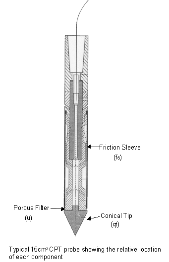
Figure 3. Schematic showing a Type 2 Shoulder
Piezocone penetrometer,
location of components and respective parameters.

Figure 4. Cross plots of non-normalized and normalized
friction ratio (Rf and Fr) versus sieve measured fines
content for the 305 and 257 data sets. Friction ratio values calculated at the
0.60m interval.

Figure 5. Cross plots of the Robertson and Fear
(1995) calculated fines content versus sieve measured fines content
for the 305 and 257 data sets showing the increase in scatter for the 305 data
due to layer effects.


Figure 6. Residual depth profiles of the 257
data set showing the difference between sieve measured fines content
minus the calculated fines content using the Robertson and Fear (1995) solution
in the upper plot
versus the optimize solution given by Eq. 3.0 in the lower plot. Note the residual
values in the
lower plot are migrated inward toward the 0 residual line indicating an improvement
in the
solution over the results shown in the upper plot. The improvement is measured
by 87 percent
of the residual values falling within the +/-10 percent boundaries for the optimized
solution (lower plot) as opposed to only 37 percent for the Robertson and
Fear (1995) solution (upper plot).

Figure 7. Cross-section showing the comparison
of the calculated fines content curves to down-hole
geophysical log signatures and stratigraphic layers. Note the high resolution
provided by the cm scale CPTu measurements. Also shown are relative facies
determined by soil type for hydrogeologic and engineering significance.