WSRC-MS-2001-00695
Wind Speed and Direction Analyses for a Group
of Southeast Surface Stations
A. H. Weber, R. L. Buckley, and M. J. Parker
Westinghouse Savannah River Company
Aiken, SC 29808
M. E. Brown
South Carolina Department of Natural Resources
Columbia, South Carolina
This report was prepared as an account of work sponsored by an agency of the United States Government. Neither the United States Government nor any agency thereof, nor any of their employees, makes any warranty, express or implied, or assumes any legal liability or responsibility for the accuracy, completeness, or usefulness of any information, apparatus, product or process disclosed, or represents that its use would not infringe privately owned rights. Reference herein to any specific commercial product, process or service by trade name, trademark, manufacturer, or otherwise does not necessarily constitute or imply its endorsement, recommendation, or favoring by the United States Government or any agency thereof. The views and opinions of authors expressed herein do not necessarily state or reflect those of the United States Government or any agency thereof.
This report has been reproduced directly from the best available copy.
Available for sale to the public, in paper, from: U.S. Department of Commerce, National Technical Information Service, 5285 Port Royal Road, Springfield, VA 22161, phone: (800) 553-6847, fax: (703) 605-6900, email: orders@ntis.fedworld.gov online ordering: http://www.ntis.gov/support/index.html
Available electronically at http://www.osti.gov/bridge/
Available for a processing fee to U.S. Department of Energy and its contractors, in paper, from: U.S. Department of Energy, Office of Scientific and Technical Information, P.O. Box 62, Oak Ridge, TN 37831-0062, phone: (865 ) 576-8401, fax: (865) 576-5728, email: reports@adonis.osti.go
1. Introduction
The Savannah River Site (SRS) uses regional-scale models to determine air transport and dispersion in the Southeast. Boundary and initial conditions to drive these models are obtained from surface and upper air data originating from the National Weather Service (NWS) stations in the region. In order to gain a greater understanding of the wind flow patterns a group of twelve NWS surface observation stations were selected for long-term wind speed and direction analyses. Ten of these stations including Augusta (AGS), Atlanta (ATL), and Macon (MCN) Georgia; Columbia (CAE) and Charleston (CHS) South Carolina; Asheville (AVL), Charlotte (CLT), Raleigh (RDU), and Wilmington (ILM) North Carolina; and Jacksonville (JAX) Florida had mostly continuous data records for more than 50 years. Savannah (SAV) and Athens (AHN) Georgia had records of 50 and 45 years, respectively.
Spatial variations in the wind patterns can be expected due to widely different terrain features in the Southeast including the Appalachian Mountains, the Atlantic coast, and the Piedmont region separating the mountains and the coast. These regional differences can be effectively illustrated with wind rose plots. Temporal changes can be identified with conventional time series analysis techniques. The data were averaged over space and time and analyzed to gain insight into the changes that have occurred over the past 50 years.
During 1964-73 the NWS stations used a three-hour instead of a one-hour data-reporting format. In January 1964, wind direction began to be reported to the nearest 10 degrees rather than to the nearest of 16 compass points. In order to produce an unbiased 16-sector wind rose for the entire 50 years, a random number in the range –5 to +5 was added to the directions for the years 1964–2000. This helped ensure that the redistribution of wind directions back into 16 sector wind roses would be unbiased.
One station, AGS, had periods during the 1950s to mid-1960s and the late 1980s when no observations were made during nighttime hours, especially the six hours after midnight. No attempt was made to correct for these omitted data or to otherwise edit the data after it was obtained from the South Carolina Department of Natural Resources.
2. Station Winds
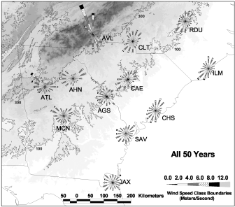
Wind speed and direction observations were obtained for the 12 Southeastern U.S. NWS stations shown in Fig. 1 and converted into statistical summaries suitable for producing wind roses. Fig. 1 shows the overall 50-year wind roses for each station.
Figure 1. Region of interest in the Southeast and NWS stations
analyzed.
The wind roses have been time-averaged over the fifty
one-year period 1950-2000. Terrain contours are at
100 and 300 m above sea level.
There are several factors that influence these wind rose patterns. The relatively steep terrain provided by the Appalachian Mountains to the west and northwest impedes approaching cyclonic weather systems and results in a wind blocking effect. Surface winds become more northwesterly, westerly, or southwesterly depending on the station’s location with respect to the mountains, as can be seen for the eight mountain and piedmont stations, particularly for ATL, AHN, MCN, CAE, CLT, and RDU. Asheville (AVL) is located in the French Broad River Valley that channels the wind north or south along the valley.
In the summer (Fig. 2) most stations show southwesterly winds from the influence of the Bermuda high-pressure center with its clockwise circulation pattern. Also in the summer, the coastal stations also show a reasonably strong on-shore component of the winds from the sea breeze effect. It is also of interest to note AGS’s strong wind rose lobe up the Savannah River in Fig. 2. This is believed to be due to sea breezes that propagate well inland from the coast and reach AGS during the evening and early-morning hours (Buckley and Kurzeja, 1997).
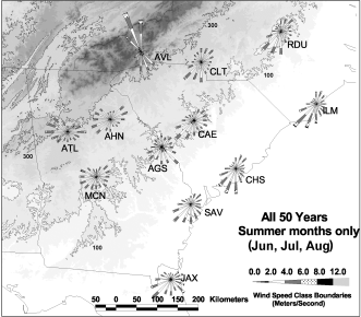
Figure 2. As for Fig.1, except that the time-averages include
only the
summer months, June, July and August.
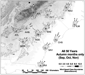
Figure 3. As for Fig.2, except that the time-averages include
only the autumn
months, September, October and November.
In autumn, high-pressure systems are often situated over the Appalachians. These high-pressure systems often act in conjunction with adjoining low-pressure systems in the North Atlantic and cause the winds in the Southeast coastal and piedmont stations to peak from the northeast (Fig. 3).
3. Temporal Variations in Wind
The annually averaged wind speeds over the 50-year period were spatially averaged for all 12 stations and the time series of winds is presented in Fig. 4. The wind speeds rose during the early 1950s but then began to fall during the late 50s and early 60s; rose slightly in the early 70s then leveled off in the mid-70s through early 90s. The wind speeds fell after the mid-90s. Overall, these averaged winds show a trend to lower speeds over the 50-year period with a decrease of about 30% in the overall averaged speed from its maximum. About one-third of this change occurred since 1995.
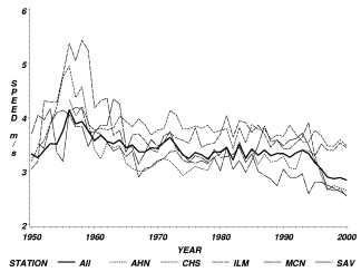
Figure 4. The annually averaged wind speeds for all stations
(heavy line) and the five
stations that have had no significant change in anemometer height
during the 50-year period 1950-2000.
Nine of the individual stations support a decreasing or steady wind speed during the 50-year period. Only ATL, AVL, and RDU are exceptions to the annual-averaged speeds decreasing with time. Factors that could have caused a decreasing wind speed include lowering or relocating the anemometer, and changes in the instrumentation or the method of recording data. In particular, after 1994 the NWS began measuring winds with Automated Surface Observing Stations (ASOS) and the time-average for wind speed measurement was extended from one minute to two minutes. This may fully explain the decrease in speed after 1994 for the ensemble of stations in Fig. 4. However, no significant changes in height (exceeding 1 meter) took place for 5 of the stations (whose individual plots are shown in Fig. 4). These station winds seem to support a premise of decreasing speed due to factors other than anemometer changes over the fifty years. Additional data will have to be examined before a firm conclusion can be reached.
The annually averaged wind direction was obtained by finding the annually averaged vector direction using the computed hourly (or three hourly) wind vector components from the reported values of wind speed and direction for the 50 year span. The 12-station annually averaged wind direction (Fig. 5) shows winds fluctuating about a northwesterly direction throughout the period except for two periods around 1957 and 1982, where there are sharp downward excursions (more northerly winds).
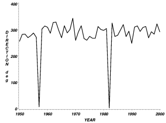
Figure 5. The annually averaged wind directions for all stations.
The individual station plots for the annually averaged wind directions shows mostly similar behavior for the wind directions (small fluctuations about a steady direction) except that nine stations have from one to four sharp downward drops as shown in Fig. 5. The station with the most downward drops in wind direction was MCN with drops in 1957, 1969, 1982, and 1994. Attempts to relate these wind direction drops to weather events or to the ENSO index have so far proved unsuccessful.
4. Spectra for Select Stations
Spectral analyses were performed for three of the stations where the time series for wind speed and direction were reasonably steady. (In general, the wind speed time series were not sufficiently steady to obtain good spectra.) Only CAE’s wind speed was selected for analysis. The wind direction time series for JAX and RDU also merited analysis.
The ENSO index time series (O’Brien, 2000) shows spectral peaks near 3.5 years and a second broader peak near 5-6 years. Another index based on pressure differences from Bermuda to Charleston, South Carolina (BCSC) was constructed to characterize the Atlantic pressure swings. This index shows spectral peaks in the vicinity of 3.5, 6.0 and 10.0 years. The spectral coherency plots of CAE’s wind speed with the ENSO index shows a wide peak from 6-10 years.
The wind direction time series from JAX shows peaks at 3 and 5-6 years, and the coherency spectrum with ENSO shows a peak of 0.95 at 6 years. The phase spectrum at a period of 6 years shows that the two spectra tend to be out of phase (about 90 degrees) with one another. The coherency of the JAX wind direction with the BCSC index shows coherency > 0.7 at periods of 2.2, 3 and 4 years. For the MCN wind direction the coherency with ENSO is greater than 0.7 at a period of 2-4 years and again at 7-12 years. The MCN wind direction and the BCSC index show strong coherency at periods of 2, 3.5 and 6-9 years. For RDU the coherency between wind direction and ENSO is strongest at 2-3, 5 and 8 years. RDU’s wind direction coherency with BCSC is strongest at 2 and 6 years.
5. Discussions/Conclusions
The wind speeds show a decrease over the past 50 years by about 30%. One-third of this decrease is probably due to changing to ASOS since 1994. Lowering anemometers may have affected some sites; however, five stations whose height was not changed significantly show a decrease in the wind speed. Average wind directions have remained fairly constant except for some peculiar shifts to the north during 1957 and 1982 at some stations. The ENSO spectra show periods of 2-4 and 7-12 years in common with the wind direction fluctuations. The coherency between the wind direction time series and the BCSC index is high between for periods of 2-3, 5-6, and 7-12 years.
References