WSRC-MS-2001-00576
Comparison of MTI Satellite-Derived Surface Water
Temperatures and In-Situ Measurements
R. J. Kurzeja, E. Villa-Aleman, and A. J. Garrett
Westinghouse Savannah River Company
Aiken, SC 29808
M. M. Pendergast
SMP Enterprises
This report was prepared as an account of work sponsored by an agency of the United States Government. Neither the United States Government nor any agency thereof, nor any of their employees, makes any warranty, express or implied, or assumes any legal liability or responsibility for the accuracy, completeness, or usefulness of any information, apparatus, product or process disclosed, or represents that its use would not infringe privately owned rights. Reference herein to any specific commercial product, process or service by trade name, trademark, manufacturer, or otherwise does not necessarily constitute or imply its endorsement, recommendation, or favoring by the United States Government or any agency thereof. The views and opinions of authors expressed herein do not necessarily state or reflect those of the United States Government or any agency thereof.
This report has been reproduced directly from the best available copy.
Available for sale to the public, in paper, from: U.S. Department of Commerce, National Technical Information Service, 5285 Port Royal Road, Springfield, VA 22161, phone: (800) 553-6847, fax: (703) 605-6900, email: orders@ntis.fedworld.gov online ordering: http://www.ntis.gov/support/ordering.htm
Available electronically at http://www.osti.gov/bridge/
Available for a processing fee to U.S. Department of Energy and its contractors, in paper, from: U.S. Department of Energy, Office of Scientific and Technical Information, P.O. Box 62, Oak Ridge, TN 37831-0062, phone: (865 ) 576-8401, fax: (865) 576-5728, email: reports@adonis.osti.gov
Abstract
Temperatures of the water surface of a cold, mid-latitude lake and the tropical Pacific Ocean were determined from MTI images and from in situ concurrent measurements. In situ measurements were obtained at the time of the MTI image with a floating, anchored platform, which measured the surface and bulk water temperatures and relevant meteorological variables, and also from a boat moving across the target area. Atmospheric profiles were obtained from concurrent radiosonde soundings. Radiances at the satellite were calculated with the Modtran radiative transfer model. The MTI infrared radiances were within 1% of the calculated values at the Pacific Ocean site but were 1-2% different over the mid-latitude lake.
Keywords: MTI, Infrared, Sea-surface, Nauru, ARM
1. Introduction
The MTI (Multispectral Thermal Imager) is a DOE satellite imager whose primary purpose is the development of technologies for nonproliferation monitoring.1,2 A primary objective of the MTI is accurate measurements of water temperatures under a variety of conditions. Water bodies are also useful as calibration targets because the emissivity of water is close to 1.0 and is accurately known over a wide wavelength range. In addition, bodies of water are usually spatially homogeneous with slowly varying temperature, which is ideal for calibration of the entire sensor array.
Calibration with water targets has become even more important to the MTI program because of the failure of the onboard calibration system in October of 2000. Much of the validation effort will involve comparison of MTI images with ocean buoy temperatures, but there is also much to be learned from a detailed analysis of MTI radiances in near optimum conditions.
Two calibration opportunities occurred on Jan 26-27, 2001 when the MTI imaged a cold lake in the Southeast US and also the water surrounding the Western Pacific Island of Nauru. The lake in the Southeast US is located on DOE’s Savannah River Site while Nauru is the location of DOE’s TWP-ARM (Atmospheric Radiation Monitoring) site. At both locations ground truth information is readily available to conduct a detailed evaluation of MTI images.
Although there are advantages to the use of water bodies as IR calibration targets, there are two disadvantages. Usually the ‘bulk’ water temperature is measured rather than the surface temperature (seen by the satellite) and differences of 1C or more are possible. These differences are caused by the formation of a cooler skin in the top millimeter of water and by daytime heating of the top meter. The skin is usually cooler than the water just below the surface because of evaporative cooling and IR heat loss. A second problem is that the effective emissivity of water is dependent on the wind speed. However, for wind speeds less than 5 m/sec and nadir viewing angles, this effect is not significant.
2. MTI Data
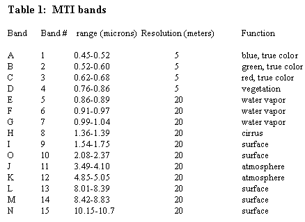
MTI bands are listed in Table 1. The first four visible bands have a resolution of 5 meters while the others have resolutions of 20 meters. The MTI imager is a push-broom type, containing three sensor chip arrays (SCA). For daytime images (south to north flight path) sensor arrays 1, 2 and 3 sample the center, right (east) and left (west) portions of the image, respectively. Variable sensor response between the SCA’s and across each is an important source of variability in the measured radiances.
Two MTI image products were used in this study, the ‘level1b_r_coreg’ and ‘level2_wst_r1’, which were processed by the Los Alamos National Laboratory using pipeline version 07031,2. The level1b_r_coreg is calibrated, top-of-atmosphere radiance for all bands and the three SCA’s have been co-registered into a single image cube. The level2_wst_r1 is the water surface temperature derived from image data using the ‘Robust Method’ and a single nadir image1.
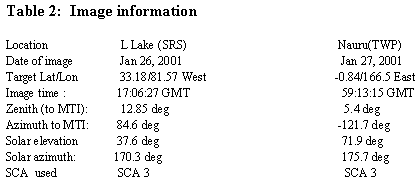
To study the absolute accuracy, we have used the same subset of chips in the SCA 3 for both targets. This choice was dictated by the relatively small size of the L Lake target area (200m x 200m). We will discuss only radiances in the 4 longest wavelength bands - K, L, M, and N. Image information is given in Table 2.
3. Ground Truth Data
3.1 L Lake
Ground truth on Jan 27, 2001 included a continuously operating sun photometer, two atmospheric soundings and measurements on L Lake at image time. The sun photometer measures direct solar radiation in 10 wavelengths, shown in Figure 1, i.e., 381 nm, 402 nm, … 1033 nm, to determine the aerosol and water vapor optical depths and the presence of cirrus clouds. Figure 1 shows the optical depths as a function of time and the mean depth and standard deviation for the 10 minutes centered at the MTI image time, 12:06 EDT. Water vapor absorption (0.94 microns) does not follow Beer’s law and will be discussed below. The results for the other wavelengths show low and steady optical depths, i.e., good visibility.
Two radiosonde balloon soundings were obtained on Jan 26 at L Lake, at 9:17 EST and at 11:51 EST, (see Figure 2). These soundings show slight variability of temperature and moisture during the morning but little change in the column (integrated) moisture between the two soundings (0.40 gm/cm2 at 9:17 EST and 0.37 gm/cm2 at 11:51 EST).
The water vapor column amount is also measured by the sun photometer and was processed following Halthore et al6. The column amount was found to decrease slowly during the morning from 0.55 gm/cm2 at 9:00 EST to 0.43 gm/cm2 at 12:06.
Ground truth data were also collected on L Lake at MTI image time. A portable, floating apparatus was anchored on the lake and recorded water temperatures at 1, 10 and 50 cm, the air temperature, relative humidity, wind speed and direction. An 8-14 micron IR radiometer measured the temperature of the ambient surface and of water pumped from 10 cm deep. The pump was operated every 10 minutes for a 10 second period. The difference between the IR temperatures with the pump off and on is a measure of the skin effect and the temperature gradient between 10 cm and the surface. We also measured the water temperature with a NIST-traceable precision thermometer, a recording platinum resistance thermometer and an IR radiometer from a boat moving slowly around the lake between 12:00 and 13:00 EST.
One-minute average IR temperatures and wind speed are shown in Figure 3, along with 10 cm temperatures obtained with the precision thermometer. In this figure the IR radiometer measurement have not been corrected for instrumental bias. This figure shows a slowly increasing temperature at 10 cm in both the precision thermometer and the pumped water temperature and a variable IR surface temperature. Between 12:00 and 12:35 the IR surface temperature is 0.2 - 0.9C less than the pumped water temperature.
Figure 3 shows a wind speed of 1.5 - 3 m/s between 16:55 and 17:35 EST. High surface temperatures are correlated with stronger winds because the cool skin layer is eroded by increased wind-induced mixing in the top few centimeters of water. The lowest surface temperatures (skin depressions of 0.9C) correspond to 1.5 m/s and the highest surface temperatures (skin depressions of 0.2C) correspond to speeds of 3 m/s. During the five minute period which included the image, the wind speed varied between 2 and 2.3 m/sec. Interpolation between the minimum and maximum yields a skin depression variability of 0.4-0.6C (Figure 3), and a standard deviation of about 0.1C.
The spatial variability of temperature around the target area was measured from a boat moving around the target area. Between 12:00 and 12:15 EDT temperatures of 8.7-8.9C were recorded at a depth of 10 cm, compared with the 8.6-8.9C (Figure 3) at the apparatus.
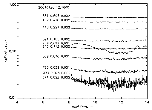
Figure 1. Sun photometer data at L Lake. To the left of each
curve is the wavelength in nm,
optical depth at image time, 12:06 EST, and the standard deviation
of the optical depth for 12:00 - 12:10.EST.
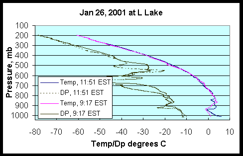
Figure 2. Radiosonde soundings at L Lake on Jan 26, 2001
The above discussion leads to the following determination of the target surface water temperature at the MTI image time. The 10 cm temperature at the floating platform determined from the precision thermometer is 8.7C ± 0.02. The variability due to the skin temperature depression is ± 0.1C (-0.4 to -0.6C) and the variation around the target area is ± 0.1C (8.6-8.9C). This leads to a surface (skin) temperature of 8.2 ± 0.2C. Note that this is a point estimate and that the MTI target area is spatial averaged and thus should be closer to a value of 8.2C than point values.
3.2 Nauru
Nauru is a DOE ARM site in the western Pacific Ocean near the equator. Extensive meteorological data are collected there, including twice-daily atmospheric soundings. The 00GMT sounding on Jan 27 is shown in Figure 4. The column water vapor for this sounding is 3.9 gm/m2. The water vapor column amount is also continuously monitored with a microwave water radiometer. This instrument recorded a water vapor column amount at the image time of 4.3 gm/cm2.
Water temperatures around Nauru are obtained from NOAA buoys near the island and from a special MTI monitoring program which collects data ~30 meters off the northwest shore of the island in deep water at image times. Data are summarized in Table 3.
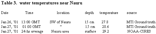
The ocean water temperature is relatively uniform in space and time except for a diurnal thermal wave in the top meter of the water. This thermal wave explains the 0.8C higher temperature at noon (01:00 GMT) compared with the midnight value 12 hours earlier (Table 3). This increase is consistent with Fairall4 for light wind conditions (3-4 m/sec). A skin temperature depression is also common in the ocean but is less variable than over inland lakes and averages about 0.4C4. Since the MTI measurement at Nauru was at a depth of 15 cm in midday with sunny skies and light winds, we assume water near the surface is a few tenths warmer than at a depth of 15 cm which will cancel the skin depression, i.e., the sea-surface temperature = 28.6C.
Satellite and buoy measurements of the sea-surface temperature are thought to be less accurate measures of the sea surface temperature than the MTI ground truth data but do suggest a greater uncertainty in the actual value. We assume a sea-surface temperature range at image time of 28.3-29.0C.
4. Modtran Calculations
4.1 L Lake
The radiance in MTI bands K, L, M, and N was calculated with the Modtran radiative transfer model with the temperature and dew point specified from the 11:51 balloon sounding (Figure2). The mid-latitude rural aerosol profile was selected and the visibility specified to be 70 km to account for the very clear air on Jan 27.
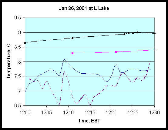
Figure 3. Temperature at L Lake. Measurements at 10cm with a
precision thermometer (triangles);
IR brightness temperatures of water pumped from a depth of 10 cm (squares);
IR surface temperatures (sold line); wind speed + 6.0 m/sec (dashed line).
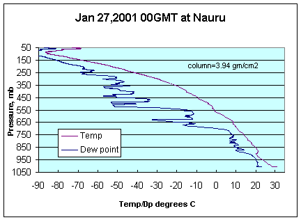
Figure 4. Radiosonde sounding on Jan 27, 2001 at Nauru
The radiance was calculated for three cases: the base case (surface temperature =281.4K), a case with 10% more water vapor at all altitudes, and a case with the sea surface temperature increased by 1C. The ratio of MTI and Modtran radiances to the base case radiances are shown in Figure 5. This figure shows that a 1 degree change in water temperature causes ~2% increase in radiance. If we consider the MTI and 281.4K ratios together, we estimate that the K, L, M and N bands imply water temperatures –0.5, 0.6, 1.2 and 1.1C different, respectively, from the base case value of 281.4. An average of these is 0.6C, i.e., a surface water temperature of 282.0K.
This can be compared with the robust temperature retrieval2 result of 281.6K. The robust method determines the nighttime (daytime ) water surface temperature from the linear combination of the brightness temperatures of bands J,K,L,M,N, (K, L, M, N). The coefficients are determined from a series of Modtran calculations for a range of water temperatures and atmospheric conditions. To improve the performance, separate sets of coefficients are used for day, night, hot and cold surfaces.
The Modtran calculation with water vapor increased by 10% did not significantly change the radiance. As noted above, the column water vapor amounts obtained with two radiosonde soundings and the sun photometer were 0.40, 0.37 and 0.43 gm/cm2, respectively. Thus, no adjustment in the water vapor column, consistent with the observations, can account for the radiance difference between the MTI data and the Modtran calculation. In summary, MTI radiances are 1% lower to 2% higher than Modtran values based on ground truth data.
4.2 Nauru
A base case Modtran calculation was performed with input parameters from the Nauru ARM site. The base case atmosphere was obtained from the Nauru radiosonde one hour before the MTI image and the water vapor was 3.9 gm/cm2 and the sea surface temperature was 301.8K. The ratios of the MTI radiances to those from the Modtran base state calculation is shown in Figure 6. This figure shows MTI radiances in reasonable agreement with the Modtran calculation in bands L, M, and N but 4% lower in band K.
A Modtran calculation with a sea-surface temperature reduced by 1C, to 300.8K, results in a minimum in the band M ratio and a maximum in the band J ratio, i.e., a worse agreement with MTI ratios. A better fit is possible if the water vapor column amount is increased by 10%, but a 2% discrepancy remains in the K band. An increase in the water vapor column amount is plausible considering that the microwave water radiometer recorded 10% more water vapor than the radiosonde sounding.
The best agreement between the MTI and Modtran radiances is when both the sea-surface temperature and the water vapor amount are increased. This is demonstrated by a Modtran calculation in which the sea-surface temperature is increased by 0.25C (302.05K) and the water vapor increased by 10% (Figure 6). These results indicate that a Modtran calculation with atmospheric data consistent with ground truth measurements yields agreement with MTI radiances in band L, M, and N to within 0.5% and in band K to 2 %. The robust retrieval temperature for this case is 300.2K.
5. Conclusions
MTI radiances in bands K, L, M, and M have been compared with Modtran calculations for a cold, mid-latitude lake with low atmospheric moisture and for the Tropical Western Pacific with warm water and high atmospheric moisture. The MTI images were collected within 12 hours of each other and the same sensor chip group in both cases. It was found that for the TWP case, the MTI and Modtran radiances were within 0.5% in bands L, M, and N and within 2 % in band K. In contrast, for the cold mid-latitude lake the MTI radiances were within 2% of the Modtran values. This is somewhat unexpected since the mid-latitude atmosphere has a higher transmissivity than the tropical atmosphere.
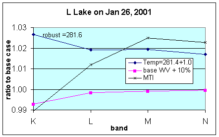
Figure 5. Ratios of radiances at L Lake
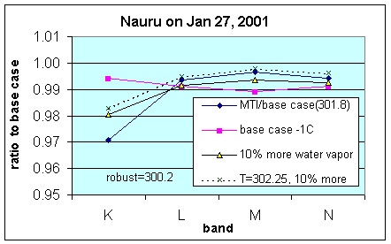
Figure 6. Ratios of radiances at Nauru
One interesting result common to both locations is that an optimum fit to the radiance dependence on wavelength is possible when the average transmission is an adjustable parameter. In the Nauru case water vapor serves this purproe because of its high concentration and uncertainty. In the L Lake case, however, the water vapor amount was too low and accurately measured to function in this way.
Acknowledgments
The Multi-Spectral Thermal Imager is a US Dept of Energy project of the Los Alamos National Laboratory, the Sandia National Laboratory and the Savannah River Technology Center. The authors thank C. Borel, W. Clodius, and K. Pollack of Los Alamos National Lab for information on MTI data products.
6. References