WSRC-MS-2001-00550
MTI Thermal Bands Calibration at Ivanpah Playa with a
Fourier Transform Infrared Spectrometer
Eliel Villa-Aleman, Robert J. Kurzeja, and Malcolm M. Pendergast
Westinghouse Savannah River Company
Aiken, SC 29808
This report was prepared as an account of work sponsored by an agency of the United States Government. Neither the United States Government nor any agency thereof, nor any of their employees, makes any warranty, express or implied, or assumes any legal liability or responsibility for the accuracy, completeness, or usefulness of any information, apparatus, product or process disclosed, or represents that its use would not infringe privately owned rights. Reference herein to any specific commercial product, process or service by trade name, trademark, manufacturer, or otherwise does not necessarily constitute or imply its endorsement, recommendation, or favoring by the United States Government or any agency thereof. The views and opinions of authors expressed herein do not necessarily state or reflect those of the United States Government or any agency thereof.
This report has been reproduced directly from the best available copy.
Available for sale to the public, in paper, from: U.S. Department of Commerce, National Technical Information Service, 5285 Port Royal Road, Springfield, VA 22161, phone: (800) 553-6847, fax: (703) 605-6900, email: orders@ntis.fedworld.gov online ordering: http://www.ntis.gov/support/ordering.htm
Available electronically at http://www.osti.gov/bridge/
Available for a processing fee to U.S. Department of Energy and its contractors, in paper, from: U.S. Department of Energy, Office of Scientific and Technical Information, P.O. Box 62, Oak Ridge, TN 37831-0062, phone: (865 ) 576-8401, fax: (865) 576-5728, email: reports@adonis.osti.gov
Abstract
The Savannah River Technology Center (SRTC) is currently calibrating the Multispectral Thermal Imager (MTI) satellite sponsored by the Department of Energy. The MTI imager is a research and development project with 15 wavebands in the 0.45-11.50 mm spectral range. The reflective bands of the MTI satellite are calibrated in desert playas such as Ivanpah Playa in the Nevada/California border. The five MTI thermal bands are calibrated with targets of known emissivity and temperature such as power plant heated lakes. In order to accomplish a full calibration at the desert playas, a Fourier transform infrared spectrometer was used to measure soil surface radiance and temperature during the satellite overpass. The results obtained with the mobile FTIR during the ground truth campaign at Ivanpah Playa will be presented.
Keywords: MTI satellite, Ground Truth, Multispectral Imaging, FTIR
1. Introduction
The Multispectral Thermal Imager (MTI) is a research and development satellite sponsored by the Department of Energy (DOE) for accurate surface temperature retrieval. The MTI mission described by Weber et al.1 is to demonstrate the efficacy of highly accurate multispectral and thermal imaging for passive characterization of industrial facilities and related environmental impacts from space. The goal is to compare the remotely sensed information from the satellite instrument to information available directly at the cooperative sites. MTI is a technology demonstration experiment, and is designed to observe a very limited number of selected sites per day, with modest spatial coverage and spatial resolution.
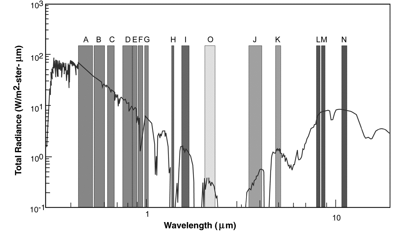
The MTI satellite has 15 spectral bands in the visible (VIS), near (NIR), short-wave (SWIR), mid-wave (MWIR) and the long-wave (LWIR) infrared spectral regions. Figure 1 shows the location of the 15 spectral bands in the electromagnetic spectrum. The spatial resolution of the spectral bands is divided in two subsets. Spectral bands A-D are 5-meter spatial resolution. Bands E through O are 20-meter spatial resolution bands. Top of the atmosphere (TOA) radiances from five thermal spectral bands in the MWIR and LWIR spectral regions (bands J [3.50-4.10mm], K [4.87-5.07mm], L [8.00-8.40mm], M [8.40-8.85mm], N [10.15-11.50mm]) are used to retrieve ground temperatures. The validation and verification ground truth targets for the temperature algorithms described by Garrett et al.2 are primarily heated/unheated lakes. Power plant heated lakes provide a field laboratory to study an extensive range of water temperatures.
Besides water targets, other natural land targets provide the opportunity to study temperatures and changes in material emissivity. Ivanpah Playa, located in the Nevada/California border, is one of the locations used in the calibration of the satellite. The primary advantages of the playas are the high reflectivity and uniformity of the terrain at a high elevation. Although the prime importance for the playas in the satellite calibration is the visible and near-infrared spectral regions, knowledge of the wavelength-dependent emissivity in the 4 - 12mm provides an opportunity for the temperature retrieval.
Remote determination of surface temperature relies on the spectral radiance reaching the satellite. The directional radiance measured at the satellite ![]() is described by
is described by
|
|
(1) |
where e l is the spectral emissivity of the surface, Lbb(l ,T) is the blackbody surface radiance given by the Planck’s law, Latm(l )¯ is the downward atmospheric radiance on the ground surface, Latm(l ) is the upward atmospheric radiance reaching the satellite and t atm(l ) is the spectral atmospheric transmissivity. Radiance measurements with the FTIR spectrometer are described by the equation (2) where transmissivity and upward atmospheric radiance are negligible.
|
|
(2) |
The MTI satellite using a combination set of spectral bands can retrieve the atmospheric transmissivity. The preferred set for water vapor retrieval is the combination of band F (water vapor, 0.91 – 0.97 mm) with bands E (water vapor reference, 0.86 – 0.90 mm) and G (water vapor reference, 0.99 – 1.04 mm). Alternatively, in the infrared spectral region, bands L (8.00 – 8.40 mm) and M (8.40 - 8.85 mm) can also extract the same atmospheric transmissivity. In contrast to the E, F, G band set that require sun light for atmosphere characterization, the bands L and M have the advantage of using the surface temperature for day or night atmospheric transmissivity measurements. The MTI satellite’s nadir and off-nadir looks and their respective different path lengths enhance the accuracy of the data acquired with the E, F, G and the L and M band sets.
On the ground, radiosonde profiles in conjunction with a sun photometer are used to measure solar radiation and atmospheric parameters. The sun photometer provides information related to the atmospheric optical depth while the radiosonde profiles provide altitude dependent relative humidity, temperature, and barometric pressure. The satellite transmissivity measurements of the atmosphere are compared with the ground truth for data validation. Once the atmospheric transmissivity has been determined, the ground surface radiance measured by the satellite can be converted into surface temperature for a known emissivity surface. It is up to the personnel conducting ground truth to provide accurate measurements of emissivity and surface temperature. MTI satellite has shown surface temperature retrievals of water targets at better than ± 2C with ground truth accurate water temperatures of ± 0.2C. MTI satellite has also shown surface temperature retrievals of land targets at better than ± 2C with ground truth accurate land temperatures of ± 1.1C.
A calibrated Fourier transform infrared spectrometer was used to measure ground surface spectral emissivity and average temperature. The soil surface radiance measured with the FTIR spectrometer for the satellite calibration was obtained from a rectangular calibration site with 80 x 280m2 dimensions. Three phenomena affect the radiance-temperature measurements by the FTIR spectrometer; the wind induced cooling effect on the soil surface, the inhomogeneous morphology of the ground surface and the ratio of the mud-cracked tile-like surface area versus crack area. The experimental results show that the wind can effect the observed temperature by more than a degree with transients as high as two degrees. The experimental results with an infrared camera also show a different temperature-emissivity composition between the cracks and the tile-like surfaces (the crack area corresponds to approximately 14% of the total surface area). Aerial thermal imagery shows inhomogeneous temperature maps of the surface at Ivanpah Playa. Besides errors in the calibration of the FTIR spectrometer (blackbody temperatures), each distinct effect contributes to the total emissivity and surface temperature standard deviation. SRTC measurements of temperature and temperature variability in conjunction with emissivity values at Ivanpah Playa will be described in this paper.
2. Experimental
A Fourier transform infrared spectrometer (FTIR), manufactured by Midac Corporation (M2400 series, the illuminator), was used to measure wavelength dependent radiance of Ivanpah Playa soil surface. The FTIR spectrometer was built with a Michelson interferometer design. The spectrometer has a 3.8cm aperture diameter with a 40 milliradians field of view (FOV). The spectrometer was equipped with mercury cadmium telluride (MCT) detector cooled with liquid nitrogen to 77K. The housing of the FTIR spectrometer was maintained at 50C with the aid of an insulated jacket with heating blankets. Heating blankets were placed above and below the FTIR. The heating blankets attached to the FTIR spectrometer were insulated from the ambient air with Styrofoam sheets and an aluminum shield. A thermocouple was attached to the FTIR spectrometer housing for temperature monitoring and control. The temperature controller maintained the FTIR spectrometer temperature within 0.2C of the selected temperature. A fan was placed inside of the spectrometer to circulate the air and to improve temperature equilibration. The instrument was warm-up for 1½ hours prior to data acquisition.
Water vapor inside of the instrument has been a problem in previous experiments. The primary water vapor source has been water condensation onto the instrument surfaces during the transfer of liquid nitrogen to the MCT detector dewar. A battery-powered air pump with a dessicant tube was used to produce dry air for the FTIR spectrometer. The water vapor problem was eliminated through the continuous flow of dry air generated by the pump.
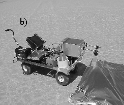
The FTIR spectrometer was attached to a jack with bolts through a rubber-insulating mat for mechanical vibration reduction control. The jack with the FTIR spectrometer was attached to a garden cart as shown in Figure 2. The cart grill dimensions are 2’x4’. The cart grill is 12" from the ground (10" diameter inflated tires). The air-inflated cart tires were responsible for the reduction of vibrations during the calibration site walk-down. The FTIR spectrometer window entrance was 21" from the soil surface. A platform with a steering beam mirror made out of stainless steel rods was attached to the FTIR spectrometer front surface. The gold-coated mirror placed at 45 degrees for nadir measurements steered the soil radiance into the spectrometer. The mirror was adjusted appropriately for off-nadir measurements. Figure 2 shows the FTIR spectrometer, blackbodies, battery, power inverter and computer assembled in the cart.
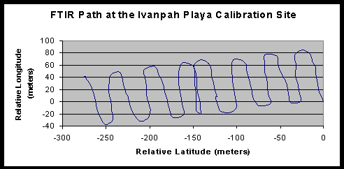
Calibration of the FTIR spectrometer was accomplished through the use of two blackbodies held at two temperatures. The temperature of the hot blackbody was set at 58C with the aid of a temperature controller. The air temperature (30-40C during the course of the experiment) primarily determined the temperature of the cold blackbody. Two hundred fifty six spectra were co-added during the blackbody and sky background measurements. The sky background was measured with a diffuse infragold-coated plate manufactured by Labsphere. The temperature of the infragold-coated plate and the blackbodies were monitored with thermistor probe manufactured by Omega with 0.02C accuracy. The soil target radiance was measured by collecting spectra every 2 seconds in our calibration area. Approximately 20 minutes worth of data was acquired during the 15 passes at the calibration site measuring 80 x 280 m2. Figure 3 shows the GPS track during the walk around through the calibration site area.
The recorded data was acquired in the following manner: 1) measure radiance of cold blackbody, 2) measure radiance of hot blackbody, 3) measure radiance of gold-coated infragold plate 4) measure soil radiance and 5) measure hot and cold blackbody radiances.
Angle dependent radiance measurements were also conducted by rotating the steering beam mirror. The angle was measured using a digital inclinometer with 0.1-degree accuracy. In these experiments, the radiance of the selected soil surface was measured with the steering beam mirror inclined at angles of 45, 40.7, 35.7, 30.6 and 25.4 degrees. The mirror inclination angles correspond to nadir, 8.6, 18.6, 28.8 and 39.2 degrees off-nadir viewing angles. The cart was moved away from the soil target area accordingly to ensure measurements at the same location. Careful alignment to the surface was made with a laser pointer attached to the FTIR spectrometer window.
Experiments with the FTIR spectrometer were conducted on May 18 and 19, 2001. May 18 experiments were conducted under a clear skies and high cirrus clouds. May 19 was mostly a cloudy day with some blue-sky openings.
Accurate calibration of the satellite requires soil surface emissivity and temperature measurements. The emissivity is an intrinsic property of the particular soil surface. Inhomogeneous soil surface with variable emissivity results in variable soil surface temperature. The emissivity/temperature surface homogeneity was studied using the FTIR spectrometer and an infrared camera (Inframetrics SC2000). Variable wind speed and air temperature can induce temperature variability at the soil surface. The effects of the air temperature, and the wind speed were studied using an experimental setup equipped with a Heimann radiometer (8-14mm), an anemometer, and sensors for air temperature and relative humidity measurements. Broadband IR and visible solar radiation were obtained with radiometers manufactured by Eppley (models PIR and PSP respectively). Surface temperature was measured with an 8-14 micron bandwidth Heimann radiometer model KT19 manufactured by Heitronics and calibrated in the laboratory to within 0.2C. The radiometer was positioned approximately 0.5 meters above the soil surface. Humidity and wind speeds were measured with a Vaisali50Y and Met One respectively. A data logger (Campbell 21X) was used to store the experimental data from the multiple sensors from the wind/temperature tower. Two duplicate towers were placed at the southeast and northwest corners of the calibration site for the May 18–19 period ground truth campaign. One meteorological tower was used at the southeast corner on May 20.
3. Results and Discussion
3.1 FTIR Measurements
Thermal calibration of the MTI satellite at Ivanpah Playa, in contrast to water targets, is complicated by the heterogeneous nature of the soil surface. Besides the spectral and spatial variability, the wind speed over the playa also affects the surface temperature. Single point measurements at the playa can be biased due to the above mentioned problems. In order to average out soil radiance measurements, the FTIR spectrometer was assembled in a mobile platform and moved over the calibration site to sample hundreds of points within ± 10 minutes of the satellite flight time.
Prior to the soil-sampling step, the FTIR spectrometer was calibrated by calculating the instrument response function (IRF) with the aid of two blackbodies. The IRF was calculated as
|
|
(3) |
where BBhot and BBcold are the raw machine units for the hot and cold blackbodies and Lhot and Lcold are the Planck distribution functions for the temperatures of the blackbodies. Once the IRF was calculated, the target radiance was calculated from
|
|
(4) |
The sky background was measured with a diffuse infragold-coated plate. The infragold-coated plate is not a perfect reflector (emissivity=0.04) and therefore has a small thermal contribution. The plate temperature was used to calculate the small radiance contribution and therefore the correction to the sky measurements. The sky radiance was calculated from
|
|
(5) |
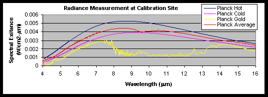
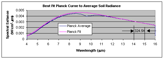
Figure 4a shows the spectral exitance of the hot and cold blackbodies and the calibration site averaged soil and 256 co-added sky measurements. Figure 4b shows the best Planckian curve fit to the soil spectral exitance and the respective calculated temperature. Once the best Planckian curve fit is known (LSoil_BB), the average spectral emissivity of the calibration site was obtained through equation 6).
|
|
(6) |
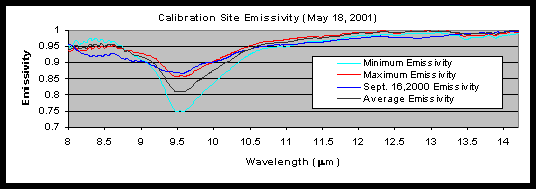
Figure 4c shows the calculated spectral emissivity for Ivanpah Playa in the 8.0 – 14.2 mm spectral range. The wavelength-dependent emissivity intensity values at the calibration site were highly variable ranging from 0.75 to approximately 0.86 at 9.55mm. The emissivity spectrum measured at the calibration site resembles very closely the desert varnish emissivity spectrum. Salisbury and D’Aria3 studied the emissivity/reflectance of terrestrial materials and the masking effect of desert varnish to rock spectrum measurements. Desert varnish is composed of manganese and ferric oxides intimately mixed with montmorillonitic clay. The only spectral feature displayed by desert varnish in the 8-12 mm spectral region is the Si-O stretching vibration band of the clay. The emissivity spectrum of varnished surfaces closely resembles the simple clay emissivity spectrum with minima peaks near 9.6 and 11.0 mm. The emissivity spectra measured on September 16 and July 4, 2000 campaigns differed to the emissivity spectrum measured on May 18, 2001. The emissivity spectra measured on September 16 and July 4, 2000 campaigns (see figure 4c) were obtained from the same location approximately 200 meter south from the May 18, 2001. The September 16, 2000 calibration site emissivity spectrum was found to contain quartz reststrahlen bands with the characteristic gap in the doublet near 8.6 mm and the weak quartz doublet between 12.2 mm and 13 mm. On closer examination, the September 16, 2000 emissivity spectrum is a combination of the desert varnish and quartz spectra.
The average soil temperature was calculated from the curve fit to the spectral exitance curve in the 14 – 15 mm spectral range. The 14 – 15 mm region was selected in temperature calculations due to the closeness of background radiance to soil radiance (the closer the background radiance to the target radiance the smaller the uncertainty in temperature calculation due to emissivity). The emissivity data acquired on September 2000 and May 2001 campaigns show variability in spectral bands and also in intensity. The 600 emissivity spectra recorded on the May 2001 campaign calibration site were found to have the same spectral features but with large swings in intensity values. The spectrum intensity values were correlated with soil spatial variability. Although the emissivity in the 14 – 15 mm spectral range is unchanged in value, a two-degree temperature difference was calculated for soil surfaces with maximum and minimum emissivity values of 0.87 and 0.75 at 9.6 mm. The average temperature for the calibration site within the 20-minute period walk around was 324.5± 1.1K (51.4± 1.1C). The average temperature include the radiance from tile-like surface and crack areas, wind dependent surface cooling and inhomogeneous surface. It is worth to point out that the single Planck curve fit used to determine the temperature is an approximation to the experimental curve produced by multiple radiance sources with numerous emissivity and temperature combinations.
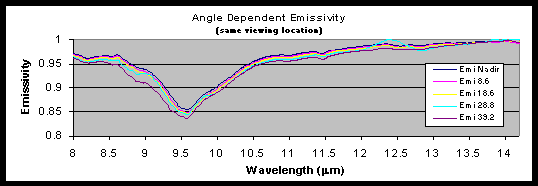
Characterization of emissivity ground properties at different angles is important for the calibration of the MTI two looks (nadir and off-nadir) in the thermal regime. The angle dependence spectral emissivity was studied by changing the angle of the FTIR gold-coated steering mirror. A diode laser beam with a special mount attachment to the FTIR entrance window was used to "paint" the ground surface for the study. The radiance of the soil surface at a given location was measured at 0, 8.6, 18.6, 28.8 and 39.2 degrees off-nadir. The laser beam was used in all measurements to ensure analysis of the same soil surface. The emissivity and temperature was calculated from the soil surface. Figure 4d shows the emissivity calculated for the nadir and 8.6, 18.6, 28.8 and 39.2 degrees off nadir angles. The calculated spectral emissivity spectra did not show any wavelength dependent spectral effects with observation angles.
3.2 Wind Speed Effects
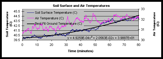
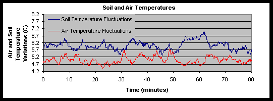
Ivanpah Playa is an extended dry lakebed covering several miles where soil temperature is "homogenous". The data analysis of the surface cooling by the wind was facilitated by the stable solar radiation during the course of the experiment. Figure 5a shows an 80-minute time window of the soil surface and air temperature data recorded at the southeast corner of the calibration site on May 20. The satellite over-passed Ivanpah Playa at 60.25 minutes in this graph. The air and soil surface temperatures show up to two degrees temperature transients. The temperature excursions are superimposed on a heating trend. Polynomial fits to the air and surface temperature curves were made to eliminate the long-term time dependent temperature trend in order to analyze the data.
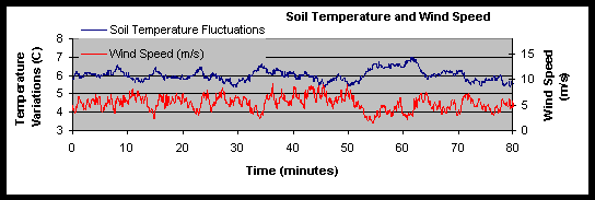
Figure 5b shows the soil temperature fluctuations and the wind speed curves. A polynomial fit to the soil temperature was used to remove the temperature trend and to produce the temperature fluctuations for analysis. The wind induced temperature standard deviation was 0.35C. The wind speed curve is highly structured and corresponds to vertical and horizontal eddies. Careful examination of the figure shows a mirror image relationship between the wind and surface temperature. The surface temperature is inversely proportional to the wind speed. This relationship holds well in the 0 and 8 meters/second wind speed range. The average wind speed during the course of the experiment was 4.96 ± 1.70m/s.
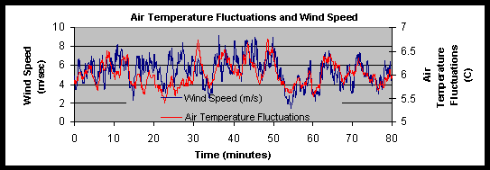
Figure 5c shows the air temperature and wind speed. The figure shows great correlation including time phase matching among these two data sets. On occasions, a large increase in wind speed was not followed by a corresponding increase in air temperature as in the case in the intervals at 24.58 and 27.33 minutes. It is possible that the increase in the wind speed at these times (24.58 and 27.33 minute) is primarily due to local downward eddies with cooler air. Further studies will be conducted to determine the local downward eddies effect in temperature characterization.
Figure 5d shows the air and soil surface temperature variations. The data clearly show the heat exchange between the soil surface and the air. The driving force behind the surface temperature cooling is the resulting energy transfer from the surface to the air powered by the wind speed. The interdependence of the kinetic temperature exchange between the air and the soil is almost one to one where a degree lost by the soil surface corresponds to a degree gained by the air and vice-versa. Since the air temperature variations precede the soil temperature variations, the data suggests that the thermodynamic equilibrium occurred prior to the measurements at the tower location. Further analysis of the data will be conducted to determine the response times and time constants for the different sensors (air, soil, and wind) and for the comparison between the two towers at the southeast and northwest locations. The results obtained at Ivanpah Playa on May 20 during clear skies represent the most ideal case scenario.
3.3 Thermal Imaging
Two different kinds of experiments were conducted at Ivanpah Playa with an infrared imaging radiometer (SC2000). The thermal imaging work conducted was divided into close-up surface analysis (1 meter above the ground surface) and aerial thermal imaging (600 meters above the ground) of the 80 x 280 m2 dimensions calibration site.
Ivanpah Playa dry lakebed consists of mud-cracked clay (tile-like) surrounded by cracks. The radiance measured with the Fourier transform infrared spectrometer during the walk around experiment in the calibration site corresponded to two different radiative sources; tile surface and tile/crack combination. Any radiance differences between the two sources could lead to a bias in the reported emissivity and surface temperature by the FTIR work. In order to clarify this issue, close-up experiments were designed with an infrared camera to understand the radiance contributions from the tile-like and crack surface areas.
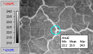
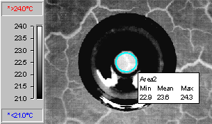
Figure 6 shows the thermal images of soil surface with and without an aluminum cone cover. At first glance, the thermal image suggests that the cracks are hotter than the corresponding tile surface. The possible scenarios that can explain the thermal image are 1) the same emissivity for the crack and tile surface areas, but different temperatures, 2) the same temperature with different emissivity, 3) same temperature and emissivity but different effective emissivity for the crack surface.
Fuchs and Tanner4, 5 demonstrated the use of a highly reflective aluminum cone in conjunction with an infrared radiometer to measure the true temperature of surfaces. The highly reflective aluminum cone placed over a surface induces the creation of a "blackbody cavity". The effective emissivity produced by the cone is described by the equation
|
|
(7) |
where r is the ratio of the apex and base areas of the cone. Placement of a highly reflective cone over the crack and tile surface areas with similar emissivity should result in a similar apparent temperature increase. The apparent temperature of the tile surface in area 2 was observed to increase from 22.2 to 22.9C while the temperature at the intersection of the cracks in area 2 remained at 24.3C. These results can be explained in the context that the walls in the crack surface already acts as a cone to produce an effective blackbody. Therefore, a reflective aluminum cone over the crack temperature has no effect in increasing the apparent temperature.
Crack versus tile surface ratio was also analyzed using visible imagery. The histogram of the images suggests that the crack area can be as high as 14% of the total area. Statistical analysis of the infrared image shows a minimum temperature of 21.4C and a maximum temperature of 24.3C. The mean temperature for the tile-crack surface area was 22.5± 0.35C. Analysis of the tile surface without cracks show a mean temperature of 22.3± 0.15C. The cone experiments were conducted early in the morning to reduce the influence of temperature changes with solar radiation. Therefore, the tile/crack surface area contributes at least ± 0.35C to the temperature uncertainty measured with the FTIR walk around study at the calibration site.
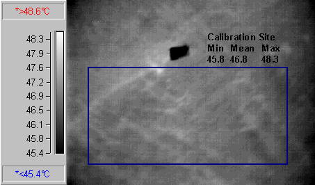
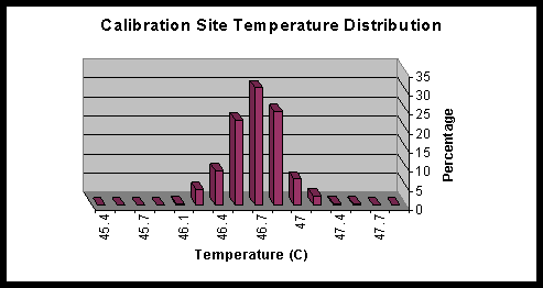
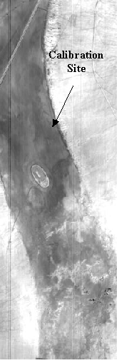
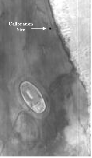
Aerial thermal imaging experiments were conducted on May 20 with an infrared camera attached to the helicopter. Figure 7a shows an infrared image of the calibration site with a tarp located in the southeast location from a 600-meter elevation. The tarp in the figure is 9 x 5.8 m2. The tarp was aligned with the long side in the south-north direction at 353 degrees (the direction of the satellite overpass). The helicopter hovered over the calibration site at elevations of 600 and 150 feet. A rectangle area of approximately 100-meter long by 50-wide was used to analyze the temperature/emissivity distribution. The maximum, mean and minimum temperatures were 45.8, 46.8 and 48.3C respectively. A closer inspection in figure 7b shows a narrower temperature distribution with a mean temperature of 46.8± 0.22C. In contrast to the fine detail observed in close-up thermal imaging experiments for the tile-like and crack surface area, the pixel resolution at the ground level is substantially degraded in aerial imaging. At 600 meters, the pixel resolution corresponds to approximately 0.5 m2. Therefore, significant apparent temperature averaging occurs in aerial infrared imaging with a washout of the tile/crack temperature distribution previously described in close-up experiments. The washout effect is responsible for the small standard deviation (0.22C) calculated from the aerial image. The temperature uncertainty in the aerial imagery probably describes the soil visible absorptivity rather than infrared emissivity (distribution in the soil reflectance corresponds to a distribution of surface apparent temperature). Similar temperature maps were observed at Ivanpah Playa with MTI thermal imagery. Figure 8a, b, and c show MTI thermal images (band N) of Ivanpah Playa and the location of the aluminized Mylar tarp on the September 16, 2000 calibration site. Figures 8b and 8c show magnifications of the calibration site. The spectral variability at Ivanpah results in reflectance, emissivity and therefore temperature variability.
4. Conclusions
Thermal analysis of the calibration site was conducted with a Fourier transform infrared spectrometer and an infrared imaging radiometer. The data from the FTIR spectrometer provided and insight into the spatial and spectral variability of the soil surface at Ivanpah Playa. Calibrated soil radiance spectra resulted in the extraction of temperature and emissivity and their uncertainty for Ivanpah Playa surface at the calibration site. The infrared camera with 8 - 12 mm spectral range window provided soil radiance and apparent temperature maps at close-up and remote (airborne) ranges. The wind speed effect on soil surface temperature was measured using a Heimann radiometer/anemometer. The soil temperature uncertainty due to natural conditions were calculated as follows; wind speed (± 0.35C), tile/crack surface area (± 0.35C) and discoloration surface area (± 0.22C). The temperature uncertainties added in quadrature resulted in a standard deviation of ± 0.54C. The analysis of the radiance data measured with the FTIR spectrometer resulted in a soil apparent temperature uncertainty of ± 1.1C for any given wavelength in the 14 - 15mm spectral region. Analysis of the temperature uncertainty discrepancy between the FTIR (± 1.1C) and the thermal camera/wind (± 0.54C) continues.
The uncertainty in the calibration of the FTIR spectrometer is ± 0.3C. Absolute temperature measurements with the FTIR spectrometer have an uncertainty of ± 1.14C. The measurements do not include solar irradiance variability. The results obtained at Ivanpah Playa suggest that a single geographical point could be used to analyze a temperature with an uncertainty of ± 1.14C.
Acknowledgments
The US Department of Energy supports this work at Sandia National Laboratories, Los Alamos National Laboratory and the Savannah River Technology Center. We appreciate the support of our colleagues at these laboratories and the support of the different private and public organizations working with us on MTI ground truth collections.
References
|
|
|
Figure 1: Calculated radiance at the MTI satellite and the 15 spectral bands. |
|
|
|
|
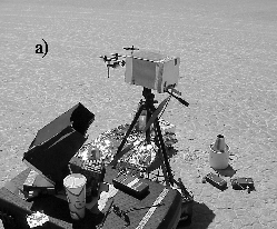
Figure 2a shows instrumentation for single point measurements. Figure 2b shows the mobile FTIR spectrometer with a 90-degree beam steering mirror for soil analysis. |
|
|
|
|
Figure 3 show the path of the FTIR spectrometer captured by a GPS unit at the calibration site. |
|
a) |
|
b) |
|
c) |
|
d) |
|
Figure 4a shows the Planckian curves for two blackbodies at curves for 333.0 and 314.1K respectively. The figure also shows the sky radiance and soil radiance respectively. Figure 4b shows the best blackbody fit to the experimental soil curve and the temperatures calculated by using only part of the experimental curve. Figure 4c shows the minimum, maximum, and average emissivity at Ivanpah Playa with emissivity on September 16, 2000. Figure 4d is the angle dependent emissivity at one location. |
|
|
|
Figure 5a shows the time-dependent soil surface and air temperatures. |
|
|
|
Figure 5b shows the cooling of the soil surface with the wind. |
|
|
|
Figure 5c shows the close relationship between the air temperature and wind speed. |
|
|
|
Figure 5d shows the interdependence between the soil and air temperatures. |
|
|
|
|
Figure 6 shows infrared images of the soil surface early in the morning. An aluminum cone shown in the upper right image was placed above the ground to increase the effective emissivity of the material, therefore providing the true surface temperature. |
|
|
a) |
|
b) |
|
Figure 7a shows an aerial thermal image of the calibration site. The black rectangle is the tarp at the southeast corner of the 80 x 280 m2 calibration site. A standard deviation of 0.22C was calculated from the image. Figure 7b shows a histogram of temperature in the selected rectangle in figure 7a. |
|
|
|
|
|
Figure 8 shows a 20-meter ground resolution distance (GRD) thermal MTI satellite image of Ivanpah Playa. From the top left in the clockwise direction are magnifications of the calibration site at Ivanpah Playa. The position of the 25 x 25m2 area "cold" aluminized Mylar tarp in the image is evident. |