![]() .
.
1)
WSRC-MS-2000-00921
Thermal Targets for Satellite Calibration
Eliel Villa-Aleman, Alfred J. Garrett, Robert J. Kurzeja,
Byron L. O’Steen, and Malcom M. Perdergast
Westinghouse Savannah River Company
Aiken, SC 29808
This report was prepared as an account of work sponsored by an agency of the United States Government. Neither the United States Government nor any agency thereof, nor any of their employees, makes any warranty, express or implied, or assumes any legal liability or responsibility for the accuracy, completeness, or usefulness of any information, apparatus, product or process disclosed, or represents that its use would not infringe privately owned rights. Reference herein to any specific commercial product, process or service by trade name, trademark, manufacturer, or otherwise does not necessarily constitute or imply its endorsement, recommendation, or favoring by the United States Government or any agency thereof. The views and opinions of authors expressed herein do not necessarily state or reflect those of the United States Government or any agency thereof.
This report has been reproduced directly from the best available copy.
Available for sale to the public, in paper, from: U.S. Department of Commerce, National Technical Information Service, 5285 Port Royal Road, Springfield, VA 22161, phone: (800) 553-6847, fax: (703) 605-6900, email: orders@ntis.fedworld.gov online ordering: http://www.ntis.gov/support/ordering.htm
Available electronically at http://www.osti.gov/bridge/
Available for a processing fee to U.S. Department
of Energy and its contractors, in paper, from: U.S. Department of Energy, Office
of Scientific and Technical Information, P.O. Box 62, Oak Ridge, TN 37831-0062,
phone: (865 ) 576-8401, fax: (865) 576-5728, email: reports@adonis.osti.gov
Abstract
The Savannah River Technology Center (SRTC) is currently calibrating the Multispectral Thermal Imager (MTI) satellite sponsored by the Department of Energy. The MTI imager is a research and development project with 15 wavebands in the visible, near-infrared, short-wave infrared, mid-wave infrared and long-wave infrared spectral regions. A plethora of targets with known temperatures such as power plant heated lakes, volcano lava vents, desert playas and aluminized Mylar tarps are being used in the validation of the five thermal bands of the MTI satellite. SRTC efforts in the production of "cold targets" with aluminized Mylar tarps will be described. Visible and thermal imagery and wavelength dependent radiance measurements of the calibration targets will be presented.
Introduction
On March 2000, the Multispectral Thermal Imager (MTI) satellite sponsored by the Department of Energy (DOE) was launched to kick-off the beginning of a research and development project for accurate surface temperature retrieval. The MTI mission described by Weber et al.1 is to demonstrate the efficacy of highly accurate multispectral and thermal imaging for passive characterization of industrial facilities and related environmental impacts from space. The MTI goal is to compare the remotely sensed information from the satellite instrument to information available directly at the cooperative sites being observed. In this role, MTI is a technology demonstration experiment, and is designed to observe a very limited number of selected sites per day, with modest spatial coverage and spatial resolution.
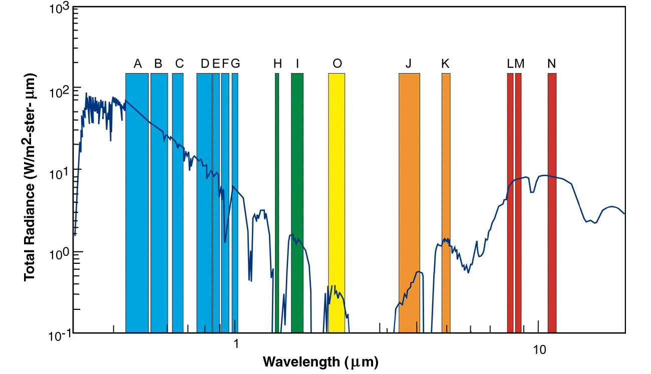
The MTI satellite has 15 spectral bands in the visible (VIS), near (NIR), short-wave (SWIR), mid-wave (MWIR) and the long-wave (LWIR) infrared spectral regions. Figure 1 shows the location of the 15 spectral bands in the electromagnetic spectrum. The spatial resolution of the spectral bands is divided in two subsets. Spectral bands A-D have a 5-meter spatial resolution. Bands E through O are 20-meter spatial resolution. Top of the atmosphere (TOA) radiances from five thermal spectral bands in the MWIR and LWIR spectral regions (bands J [3.50-4.10mm], K [4.87-5.07mm], L [8.00-8.40mm], M [8.40-8.85mm], N [10.15-11.50mm]) in conjunction with five algorithms are used to retrieve ground temperatures. The validation and verification ground truth targets for the temperature algorithms described by Garrett et al.2 are primarily heated/unheated lakes. Power plant heated lakes provide a field laboratory to study an extensive range of water temperatures. The temperature range found in natural water targets and power plant heated lakes are from 1 to 50C.
Besides water targets, other natural land targets provide the opportunity to study high temperatures and changes in material emissivity. Ivanpah Playa located in the Nevada/California border is one of the locations used in the calibration of the satellite. The primary advantages of the playas are the high reflectivity and uniformity of the terrain at a high elevation. Although the prime importance for the playas in the satellite calibration is the visible and near-infrared spectral regions, the variability of the emissivity in the thermal spectral range provides an opportunity for the temperature retrieval.
The terrain at Kilauea and Mauna Loa volcanoes in Hawaii has been used in the calibration of other satellites. The active Kilauea volcano with its hot lava flows provides a target to the MTI satellite for high temperature calibration and retrieval.
Two additional potential "thermal targets" have been identified for the satellite calibration. Aluminized Mylar tarps offer the opportunity of providing a target with low emissivity (0.04). The low emissivity of the aluminized Mylar tarps results in the reflection of the cold skies (–50C apparent temperature) toward the satellite. Removal of the aluminized Mylar tarps from the soil surface can introduce a cooled area with the same emissivity as the surrounding heated playa. The temperature contrast produced by the removal of the aluminized Mylar tarp on the desert playa can aid in the determination of the minimum resolvable temperature.
Experimental
Accurate temperature measurements in water and land targets were recorded with a variety of contact sensors and radiometers. Contact sensors such as glass thermometers, thermocouples and thermistor probes traceable to NIST were used in our temperature measurements. Two infrared imaging radiometers manufactured by Inframetrics (760 and SC2000) were used to acquire our infrared imagery. Single-point radiometers such as the KT19 and KT15 Heimann models manufactured by Heitronics with an 8-14mm bandwidth were also used to measure the temperature of our targets. The radiometers used in our field campaigns were calibrated in our laboratory to ± 0.2C with blackbodies traceable to NIST.
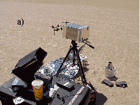
A Fourier transform infrared spectrometer (FTIR), manufactured by Midac Corporation, was used to measure wavelength dependent radiance of our targets of interests. Accurate radiance measurements require a constant temperature instrument. The FTIR spectrometer was maintained at a constant temperature with the aid of a blanket heater and a jacket insulator. The FTIR was assembled in a cart equipped with blackbodies, battery, power inverter and computer as shown in Figure 2.
Calibration of the FTIR spectrometer was accomplished through the use of two blackbodies held at two temperatures. The temperatures of the blackbodies were chosen above and below the soil temperature. Five hundred twelve spectra were co-added during the blackbody and background measurements. The sky background was measured with a diffuse infragold-coated plate manufactured by Labsphere. The temperature of the infragold-coated plate was monitored with thermistor probe manufactured by Omega with 0.02C accuracy. The soil target radiance was measured by collecting spectra every 4 seconds in our satellite calibration area. Approximately 15 minutes worth of data was acquired during our 10 passes at the calibration site measuring 80 x 320 square meters.
Characterization of water targets was accomplished primarily with a combination of contact sensors and radiometers. Water temperature measurements were conducted with a "Skin Temperature Rig" built in our laboratory. In our methodology, the rig was anchored at the exit of the heated water plume from the power plant to the lake and at the middle of the lake to measure water and air temperatures, humidity, wind speed, broadband IR, visible heat exchange. Water temperatures were measured using thermocouples calibrated to 0.1C and the data downloaded to a data logger (Campbell CR10). Broadband IR and visible heat exchange were obtained with radiometers manufactured by Eppley (models PIR and PSP respectively). The water skin temperature was measured with an 8-14 micron bandwidth Heimann radiometer manufactured by Heitronics and calibrated in the laboratory to within 0.2C. The radiometer was positioned approximately 0.5 meters above the water. Humidity and wind speeds were measured with a Vaisali50Y and Met One respectively.
The skin depression was determined by comparing the temperature measured with the radiometer (skin temperature) and a thermocouple at 10 cm below the surface (bulk temperature). This approach requires precise field calibrations, so the skin temperature depression was also determined by comparing radiometer measurements of the natural water surface and the ‘stirred’ surface. The ‘stirred’ surface temperature was obtained by pumping a jet of water from 10cm below the surface into the radiometer’s field of view. Because the skin depression takes approximately 10 sec to form, the stirred temperature will be equivalent to the bulk temperature. The "Skin Temperature Rig" was also used to provide ground truth for aerial thermal imagery collected with our infrared cameras.
Results and Discussion
Water Targets
The measurement of ocean bulk water temperature from satellite-borne radiometers has been a quest by the scientific community for the past several decades (Robinson et al.3). Satellite-borne radiometers measure the skin temperature. The skin water temperature is defined as the temperature of the top 1mm. In general, the skin temperature is typically 0.5 –1.0C less than the bulk water (uppermost 10 centimeters of water), the quantity usually measured from ship or buoy. The skin effect is more significant over bodies of fresh water because of the greater variability of water temperature, air temperature, wind and humidity. The skin temperature depression can be as large as 3° C over heated bodies of water, or even positive, as is the case of warm and humid air over cold water. Understanding the skin temperature effect is of practical importance for ground truth programs because the bulk temperature is much easier to measure accurately than the skin temperature. The most important factors which govern the skin temperature effect are the exchange of IR radiation between the water surface and the atmosphere, heat transfer from the surface to the atmosphere via latent and sensible heat flux, and mixing of the sea surface. Typically, the skin temperature depression is increased by radiative loss and evaporation and decreased by turbulent transport of heat upward through the bulk water layer.
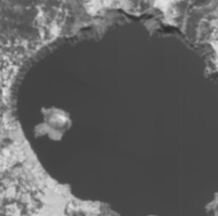
Pilgrim Power Plant, Turkey Point Power Plant, Comanche Peak Power Plant, H.B. Robinson Power Plant, Crater Lake and Nauru island are the cooperative sites for the MTI thermal calibration. The power plant heated lakes have been instrumented with an array of sensors to monitor bulk water temperature at several locations. In addition, full-fledged campaigns have been conducted to provide air and skin and bulk water ground truth at the cooperative sites during satellite overpass. The cooperative sites were chosen due to their unique thermal "fingerprints" with varying atmospheric conditions. Thermal images acquired with the MTI satellite of Turkey Point Power Plant, H.B. Robinson Power Plant, Comanche Peak Power Plant and Crater Lake are shown in Figure 3. Previous aerial thermography studies (Villa-Aleman et al.4) provided a thermal baseline at H.B. Robinson and Turkey Point Power Plants.
Ivanpah Playa Soil
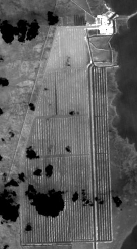
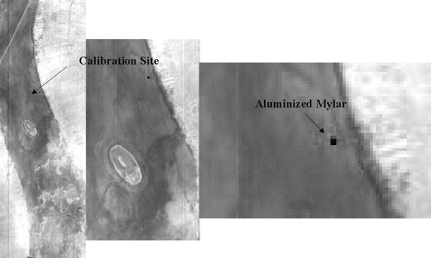
Thermal calibration of the MTI satellite at Ivanpah Playa, in contrast to water targets, is complicated by the heterogeneous nature of the soil surface. Figure 4a shows the thermal band N image of Ivanpah Playa. Figures 4b and 4c show magnifications of the calibration site at Ivanpah Playa. The spectral variability at Ivanpah results in reflectance, emissivity and therefore temperature variability. Besides the spectral variability, the wind speed over the playa also affects the surface temperature. Single point measurements at the playa can be biased due to the above mentioned problems. In order to average out soil radiance measurements, the FTIR spectrometer was assembled in a mobile platform and moved over the calibration site to sample thousands of points within ± 10 minutes of the satellite flight time.
Prior to the soil-sampling step, the FTIR spectrometer was calibrated by calculating the instrument response function (IRF) with the aid of two blackbodies. The IRF was calculated as
|
|
1) |
where BBhot and BBcold are the raw machine units for the hot and cold blackbodies and Lhot and Lcold are the Planck distribution functions for the temperatures of the blackbodies. Once the IRF was calculated, the target radiance was calculated from
|
|
2) |
The sky background was measured with a diffuse infragold-coated plate. The infragold-coated plate is not a perfect reflector (emissivity=0.04) and therefore has a small thermal contribution. The plate temperature was used to calculate the small radiance contribution and therefore the correction to the sky measurements. The sky radiance was calculated from
|
|
3) |
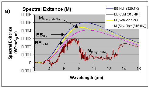
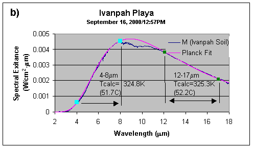
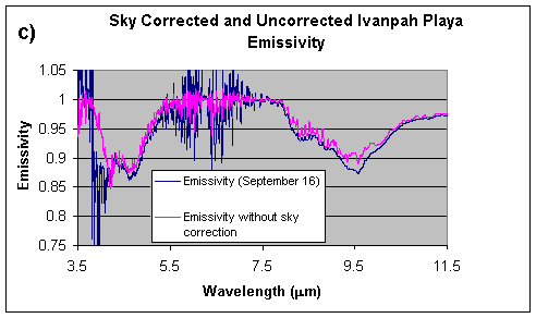
Figure 5a shows the spectral exitance of the hot and cold blackbodies and the soil and sky measurements. Figure 5b shows the best Planckian curve fit to the soil spectral exitance and the calculated temperature. The two temperatures shown are the result of two different regions used during the best-fit interactive routine. Once the best Planckian curve fit is known (LSoil_BB), the average emissivity of the calibration site was obtained through equation 4).
|
|
4) |
Figure 5c shows the calculated emissivity for Ivanpah Playa in the 4.5 – 13.5mm spectral range with and without the sky radiance contribution Lsky. Comparison between temperature retrieval of the Ivanpah Playa calibration site by the MTI satellite and the temperature calculated from the FTIR measurement data is in progress.
Aluminized Mylar Tarp
Cold areas with known geometrical dimensions on the desert surface can offer an opportunity for conducting experiments in satellite calibration. Natural cold areas with the proper dimensions and attributes are not easily available and in general require man-made efforts to develop them. Aluminized Mylar with its low emissivity was originally manufactured for space programs to keep satellites safe from solar radiation and heating. The same material can also be used to make reflective tarps. The tarps can then be used to reflect solar radiation from the desert surface thus creating a cold area in contrast to the continuously exposed sand.
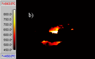
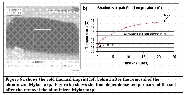
The low emissivity of the aluminized Mylar can be exploited to create two types of cold areas on the desert surface. In one case, the aluminized Mylar tarp can be used as a shield (reflector) against solar irradiation on the sand. At a predetermined time prior to the satellite overpass, the tarps can be removed to expose the colder sand to the satellite. A temperature contrast between cold shaded area and the surrounding hot sand can fall between 3 to 11C. The advantage of this method in the creation of a cold target is the retention of a constant emissivity (sand) across the hot and cold boundaries. Figure 6a shows the thermal imprint left behind on the ground after the removal of a 5’ x 3’ aluminized Mylar tarp. In this experiment, the soil was covered with the aluminized Mylar early in the morning. Figure 6b shows a graph of the time dependence soil temperature. The temperature of the surrounding soil area was 44.3C.
A second type of cold pixel can be created by the reflection of the cold skies (–50C to –20C) by the aluminized Mylar in the direction of the satellite position. The MTI satellite has the capability to image a target with two views (nadir and at 55 degree from nadir). The apparent temperature of the sky is dependent on the observation angle with the coldest at the zenith view. Therefore, the two views of the satellite in the direction of the aluminized Mylar target can produce two completely different apparent temperatures due to the skies sampling location.
The cold sand target allows testing the minimum resolvable temperature of the satellite’s detector. The ground sampling distance (GRD) of the satellite is 20 meters. A cold target of 50 x 50 meters2 ensures that the satellite pixel falls in the designated area. Depending on the alignment of the satellite detector pixel array on the aluminized tarps on the ground, it is possible for the cold target to fill up to two pixels. The 50x50 meter2 also insures that the second view at 55-degree can observe a cold pixel.
The second cold target created by the reflection of the cold skies by the aluminized Mylar target can test the dynamic response of the detector. The target at a –50C apparent temperature surrounded by sand around 52C is ideal in producing a thermal step function on the satellite’s detector. Figure 7 shows a visible picture of the 50x50m2 and a 25x25m2 tarp aerial overview. Figure 4 shows the satellite thermal image of the 25x25m2 aluminized Mylar tarp at Ivanpah Playa.
Kilauea Volcano
Lava flows at Kilauea volcano in the island of Hawaii are relatively young (<1000 years). Two types of lava flows distinguish the surface (aa and pahoehoe). Thermal spectra of the cold lava flows are modified by chemical changes brought by aging processes. The spectral changes are the consequence of the oxidation of iron, accumulation of silica-rich coatings and the devitrification of the thin crusts common on fresh pahoehoe. Temperature measurements with satellite-borne radiometers require a priori knowledge of the target emissivity. Since the emissivity of different lava flows is affected by aging, the temperature and emissivity are intermingled. Kahle et al. 5 examined the relative dating of Hawaiian lava flows using multispectral thermal infrared imagery.
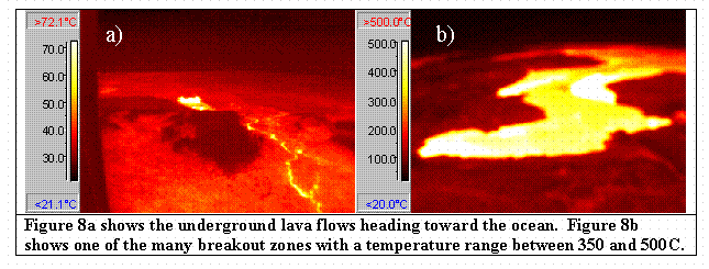
Kilauea volcano has been active for the past 20 years. Lava continuously flows to the ocean through a series of underground tubes as shown in Figure 8a. Skylights (opening of the lava tubes to the sky) present an opportunity to study underground lava flows. A typical lava flow temperature is approximately 1150C. Above the lava tubes, breakout zones are readily available where new lava emerges and solidifies around 770C. Figure 8b shows an infrared image of one of the many breakout zones. Extended areas of breakout zones (200m2) with temperatures in the 200 – 700C are not uncommon. The skylight and breakout zones offer an opportunity to conduct high temperature calibration for the MTI satellite. The skylight shown in Figure 9 provide an extremely hot target to study sub-pixel resolution while the breakout zone areas provides extended areas of highly elevated temperatures (200C-500C).
Unfortunately, Nature has a way of expressing itself during experimentation. The skylight available at Kilauea at the present time is enclosed in a cave with a very limited view to the satellite. The limited view of the skylight in conjunction with the large thermal dilution (cold surrounding terrain) hinders its use as a calibration target. The breakout zones at Kilauea also presents a distinct challenge. The thermal heterogeneity of the breakout zones requires area averaging temperature measurements. Although these area averaged temperature measurements for satellite calibration are plausible, the time dependent geographical location and temperature of the breakout zones present a major experimental challenge. During the studies at Kilauea, it became evident that the breakout zone was a moving target that can only be selected just few hours before the satellite overpass. Weather is also another contributor to the experimental difficulties in the study of Kilauea volcano. Kilauea is located on the wet side of the island of Hawaii. Clouds hindered the view of the satellite during our ground truth campaigns. Rains can also dramatically decrease the temperature of the breakout zone and produce steam clouds.
In summary, the skylights and the breakout zones at Kiluea volcano present an opportunity to study elevated temperature of sub-pixel resolution and thermal extended areas respectively. However, ground truth studies are difficult and require great effort in preplanning and a rapid deployment execution.
Conclusions
A variety of natural and man-made thermal targets have been used in the calibration of satellites. Water targets, Ivanpah Playa, aluminized Mylar tarps, and Kiluea volcano terrains were used to provide the MTI satellite with unique conditions for thermal calibration. Targets at several power plant heated lakes and Ivanpah Playa were determined to be the easiest for calibration. Water targets provided highly known spectral emissivity and accurate temperature measurements to ± 0.02C. Ivanpah Playa soil provided a variable spectral emissivity with temperature retrievals of ± 0.07C.
Acknowledgments
The US Department of Energy supports this work at Sandia National Laboratories, Los Alamos National Laboratory and the Savannah River Technology Center. We appreciate the support of our colleagues at these laboratories and the support of the different private and public organizations working with us on MTI ground truth collections.
References
|
|
|
Figure 1: Calculated radiance at the MTI satellite and the 15 spectral bands. |
|
|
|
|
Figure 2a shows instrumentation for single point measurements. Figure 2b shows the mobile FTIR spectrometer with a 90-degree beam steering mirror for soil analysis. |
|
|
|
|
|
|
|
Figure 3 shows thermal MTI images of cooperative water target sites. The water targets from the left are Turkey Point Power Plant, H.B. Robinson Power Plant, Comanche Peak Power Plant and Crater Lake. |
|||
|
|
|
Figure 4 shows a 20m GRD thermal MTI satellite image of Ivanpah Playa. From the left are magnifications of the calibration site at Ivanpah Playa. The position of the 25 x 25m2 area "cold" aluminized Mylar tarp in the image is evident. |
|
|
|
|
|
|
|
Figure 5a shows the Planckian curves for two blackbodies at curves for 329.7 and 316.4K respectively. The figure also shows the sky radiance and soil radiance respectively. Figure 5b shows the best blackbody fit to the experimental soil curve and the temperatures calculated by using only part of the experimental curve. Figure 5c shows the calculated emissivity of Ivanpah soil with and without the sky correction. |
|
|
|
Figure 7a shows the 50x50m2 aluminum Mylar tarp. Figure 7b shows an aerial overview of a 25x25m2 aluminum Mylar tarp. |
|
|
|
Figures 9a and 9b are the visible and infrared images of the skylight at the Kilauea volcano. Temperature of the skylight is approximately 1100C. |