WSRC-MS-2000-00098, Rev. 1
Using Antibiotic Resistance and Aquatic Variography
to Test the Information Length Hypothesis
R. C. Tuckfield and J. V. McArthur
Westinghouse Savannah River Company
Aiken, SC 29808
This report was prepared as an account of work sponsored by an agency of the United States Government. Neither the United States Government nor any agency thereof, nor any of their employees, makes any warranty, express or implied, or assumes any legal liability or responsibility for the accuracy, completeness, or usefulness of any information, apparatus, product or process disclosed, or represents that its use would not infringe privately owned rights. Reference herein to any specific commercial product, process or service by trade name, trademark, manufacturer, or otherwise does not necessarily constitute or imply its endorsement, recommendation, or favoring by the United States Government or any agency thereof. The views and opinions of authors expressed herein do not necessarily state or reflect those of the United States Government or any agency thereof.
This report has been reproduced directly from the best available copy.
Available for sale to the public, in paper, from: U.S. Department of Commerce, National Technical Information Service, 5285 Port Royal Road, Springfield, VA 22161, phone: (800) 553-6847, fax: (703) 605-6900, email: orders@ntis.fedworld.gov online ordering: http://www.ntis.gov/support/ordering.htm
Available electronically at http://www.osti.gov/bridge/
Available for a processing fee to U.S. Department of Energy and its contractors, in paper, from: U.S. Department of Energy, Office of Scientific and Technical Information, P.O. Box 62, Oak Ridge, TN 37831-0062, phone: (865 ) 576-8401, fax: (865) 576-5728, email: reports@adonis.osti.gov
Stream ecosystems have effective mechanisms for the biotransformation of natural terrestrial inputs, largely due to native bacteria1. These organisms are crucial to an ecosystem’s homeorheic machinery. Natural selection may account for local adaptations by some bacteria to different terrestrial inputs in different streams or in different reaches of the same stream, inputs that vary with geology, and riparian vegetation2. But do such adaptations occur in response to non-natural terrestrial inputs? We show here that antibiotic resistance among stream bacteria is a spatially correlated phenomenon in a stream at the US Savannah River Site (SRS) with a history of heavy metal contamination, a phenomenon which is absent in another SRS stream with no contamination history. We further show that this spatial correlation is higher within more contaminated reaches of the same stream. These findings are consistent with predictions arising from the Information Length Hypothesis3 (ILH).
ILH posits that the downstream spatial distribution of bacteria and/or their genes will depend on selection pressure to process local stream inputs. The length of stream over which specific genes are adaptive is referred to as the information length. To test the ILH, we collected 67 sediment samples (50 cc per sample) along and within a 13 km reach of Four Mile Creek (Fig. 1) at the SRS during the summer of 1998, and 62 samples along and within a 12 km reach of Meyers Branch in 1999. The objective was to identify spatial patterns, if any, of antibiotic resistance corresponding to heavy metal inputs within these stream ecosystems. Antibiotic resistance has been shown to be a genetically linked trait to heavy metal tolerance4. Four Mile Creek has a history of heavy metal inputs, while Meyers Branch does not.
ILH predicts that streams with point-source terrestrial inputs will exhibit longer information lengths than streams without such inputs, as well as longer information lengths in reaches of the same stream where these inputs occur. McArthur and Tuckfield3 proposed using the range parameter from the geostatistical variogram (see Appendix) as an estimate of information length. Specifically, ILH predicts a longer variogram range for Four Mile Creek than for Meyers Branch, as well as longer ranges in more contaminated reaches of Four Mile Creek.
An errors-in-variables linear regression5 was performed which shows a positive relationship between the bacteria counts for control growth plates and the bacteria counts for each of two antibiotic treatments - streptomycin (r2=0.31, p<.0001) and kanamycin (r2=0.27, p<.0001), respectively (Fig. 2). The ratio of the antibiotic resistance count to the control count is a measure of the relative incidence of antibiotic resistance per sample location. The logarithm of this ratio preserves the normality assumption for statistical modeling.
Antibiotic resistance ratios (i.e., their logarithms, hereafter) in Four Mile Creek exhibit a convex spatial pattern with distance downstream from the headwaters for both streptomycin and kanamycin. The maximum is obtained in the midreach of Four Mile Creek (Fig. 3) near its confluence with a tributary stream which drains an industrial and nuclear reactor complex. The furthest upstream sample collected in Four Mile Creek is below an industrial processing facility outfall which, historically, has transported heavy metals into this stream6,7. At the tributary confluence, sediment samples averaged 50 ppb of Hg per gram dry weight compared to a background of 5-10 pbb for the Savannah River site. The tributary also exhibits elevated concentrations of heavy metals in its sediments. The highest relative incidence of antibiotic resistance (100%) in the entire study occurred in a tributary sediment sample with the highest mercury concentration (85 ppb). However, this convex spatial pattern of antibiotic resistance ratio with downstream distance is absent in Meyers Branch, and even appears concave for kanamycin resistance (Fig. 3).
Before testing the specific ILH predictions, and with the exception of streptomycin in Meyers Branch (Fig. 3), the residuals were retained from a second order polynomial regression of antibiotic resistance ratio on downstream distance to preserve the important geostatistical assumption of intrinsic spatial stationarity8. Standardized variograms9 were fit to antibiotic resistance ratio residuals using a spherical model to obtain estimates of the variogram range (r) for each stream and antibiotic.
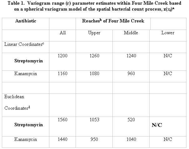
The standardized variograms in Figure 4 show the range parameter estimates (r>0) for both antibiotics in Four Mile Creek. These data indicate a spatial correlation among sampling locations separated by less than about 6 distance units (1200m) apart in Four Mile Creek, but not in Meyers Branch. This evidence supports the first ILH prediction, as illustrated by a simple comparison of range parameter estimates between streams for each antibiotic (Fig. 4).
The stream sampling locations in Four Mile creek were then separated into three groups with 22, 23, and 22 locations in each group corresponding to the lower, middle, and upper reaches of the stream, respectively. ILH predicts longer variogram ranges for antibiotic resistance in the upper and middle reaches of this that are in closer proximity to the point sources of heavy metal contamination from the H-area industrial facility6. The standardized variograms in Figure 5 support this prediction. A comparison of variogram range parameter magnitudes (Table 1) is possible by inferring that no evidence of spatial correlation in the lower reach for either antibiotic means r![]() 0. Meyers Branch was also divided into three reaches with 20, 21, and 20 sample locations in the upper, middle, and lower reaches, respectively. The only evidence of spatial correlation occurs in the middle reach of Meyers Branch for streptomycin.
0. Meyers Branch was also divided into three reaches with 20, 21, and 20 sample locations in the upper, middle, and lower reaches, respectively. The only evidence of spatial correlation occurs in the middle reach of Meyers Branch for streptomycin.
Table 1 shows an additional comparison of variogram range parameter estimates (to the nearest three significant figures) using two different spatial coordinate systems. Estimates obtained using linear coordinates for each antibiotic and stream reach in Four Mile Creek are more consistent between the upper and middle reaches for both antibiotics than those obtained by the standard method of Euclidean coordinates. Variogram ranges estimated using linear within-stream coordinates are more easily interpreted. However, the Euclidean coordinate system may be more appropriate for estimation when flood event sediment deposition is frequent and expansive.
Geostatistical variograms have identified patterns of spatial correlation in other ecological variables among birds, barnacles, arthropods, shrubs and trees10-17. Our variograms, as those of Villard and Mauer10 for breeding bird counts, exhibit what are commonly called "hole effects"8 wherein the response measure shows an increase in spatial correlation at distances greater than the variogram range. Hole effects are exhibited in the middle reach of Four Mile Creek (Fig. 5) for both antibiotics. This suggests that the selection agent operating in the upper reach of Four Mile Creek may been overlain by a second selection agent in the middle reach. The result is a variogram that exhibits a spatial correlation pattern for antibiotic resistance at two different scales, a kind of out-of-phase amplification of the upstream selection agent occurring in the middle reach. Current research by the authors will examine the spatial correlation in heavy metal contamination among the same stream sediment samples used here for plating bacteria. If the spatial patterns for heavy metals are similar to those for antibiotic resistance, they will confirm the suspected causality of the former as the selection agent. The relative incidence of heavy metal resistance should be positively correlated with the relative incidence of antibiotic resistance.
We have demonstrated a local scale spatial pattern for genetic information within a stream that is likely an adaptive response to stream ecosystem inputs. This implies that genes can be considered properties of an ecosystem. Naturally occurring gene frequencies, for a given ecological time slice, are tantamount then to labels or markers which confer a unique ecosystem identity, an identity as distinctive as between western montane and southeastern coastal plain streams in the US. Although the recently suggested scale for bacterial distribution research is biogeographic18, we submit that the investigation of smaller scale ecological relationships among microbes will yield an important prerequisite understanding for the explanation of global phenomena.
Methods
Site Description
Four Mile Creek is a third order upper coastal plain stream draining a 5,894 ha watershed located on the SRS. Stream temperatures range from 9.0 to 25ºC and pH from 5.10 to 8.10, (median = 6.09). Four Mile Creek received thermal effluent (>50ºC) from reactor operation until 1987 at flows 10 times higher than ambient (40 m-3 to over 400 m-3). These flows caused major geomorphological changes within the stream essentially scrubbing the channel of all organic matter and in-stream structure. All riparian vegetation was killed. In addition, several chemical seepage basins were established in the headwater reaches of the stream and used continuously for 30+ years. These basins received chemical effluent composed of tritium, nitrate, and various metals. Although the basins have been capped, leachate continues to seep into the stream. The stream has been undergoing natural recovery since cessation of thermal inputs in 1987.
Meyers Branch is a third order, relatively pristine blackwater stream on the SRS, set-aside for ecological research. Meyers Branch drains an approximately 5085 ha watershed. It originates in the sand hills of the upper coastal plain and has an extensive riparian floodplain. It has a mean annual temperature of ~16°C and a pH range from 5.8 to 8.3 with a median of 6.9.
Sediment Sampling
Sampling locations were established 200m apart within the main stream channel of both Four Mile Creek and Meyers Branch using GIS. Points were identified using interpolation of coordinates from the UTM North American Datum 1927 projections. The Global Positioning System (GPS) coordinates were generated for all sampling points and portable GPS equipment used to locate them. Each sampling location also possessed linear within-stream coordinates. These comprise a number from 1 to 67 as the northing coordinate and a constant value of 1 for the easting coordinate. The linear coordinate system served also as a distance measure since each sampling location was a constant 200 m (+/- 1.5 m) apart. At each sampling station one 50 cc core (diameter @ 2.5 cm) was taken from bank sediments, placed on ice in a sterile bag, and transported to the laboratory.
Bacteria Plating
Approximately 5 g of sediment per sample were removed, gently sonicated to detach bacteria, serially diluted and plated on three different plates. Control plates consisted of half strength nutrient broth with 100 mg of cycloheximide added to control fungal growth. The remaining plates were identical to the control plates except the addition of 100 m g of either streptomycin or kanamycin. Each set of three plate was inoculated from an extract prepared from a single sediment sample. After the inoculant was removed, sediments were collected, dried (60°C) and weighed.
Colony counts were made after 6 d incubation at room temperature (~20°C). Each count was adjusted for sample volume by adding 1 to the count and dividing by the corresponding sediment dry weight.
Variogram Model Fitting
When sample measurements are spatially correlated, the variation among measurements separated by a distance h apart is smaller relative to a similar set of spatially uncorrelated sample measurements6. The range (r > h) is defined the minimum separation distance between sample measurements such that the spatial correlation is effectively zero. The geostatistical variogram6 (see Appendix) can be used to estimate r for a given spatial response measure, such as the antibiotic resistance ratio among stream bacteria. The range is obtained at a lag distance (h) such that approximately 95% of the asymptote (or sill)7 is achieved.
The choice of scale for fitting standardized variograms was often a tradeoff between the number of semivariance values and "smoothness". Large lag distances yielded smoother semivariance patterns with increasing separation distance between sample locations, but fewer points for model fitting. Empirical variograms were produced for a variety of lag distances within reaches - from 1 to 5 in increments of 0.5 - to examine this tradeoff prior to model fitting, and to ensure that the apparent range was consistent among most lag distances.
References
We thank Philip Dixon for a preliminary review of this manuscipt, and James.
S. Bollinger for assistance in preparing the graphics for Figure 1.
A measure of spatial continuity among pairs of sampling locations ![]() represented in a cartesian plane and for a separation vector h is known as the variogram (
represented in a cartesian plane and for a separation vector h is known as the variogram (![]() ). The variogram here is defined here as the sum of squared deviations in antibiotic resistance ratio measurements among all pairs of sampling points separated h distance units apart and is represented as
). The variogram here is defined here as the sum of squared deviations in antibiotic resistance ratio measurements among all pairs of sampling points separated h distance units apart and is represented as
(1)
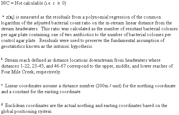
where N(h) is the number of sample points with a separation distance h, and z(xi) and z(xi + h) are the bacterial colony counts for the ith easting and northing coordinate location and its paired location +h distance units away, respectively. The emboldened letter h indicates a separation vector, that is, a Euclidean distance between sampling locations in 2-space, or a linear distance along the stream channel. Figure 1 is a plot of the sampling locations in easting and northing coordinates showing the stream flow direction from upper right (northeast) to lower left (southwest) towards its entry into the Savannah River. This figure also shows how each value of the lag interval (h) was calculated either as the linear within stream distance between sampling locations or as the Euclidean distance vector.
The spatial covariance among bacterial colony counts![]() for each separation vector in the stream is defined as
for each separation vector in the stream is defined as
(2)
where
(3)
are the antibiotic resistance ratio averages among successive pairs of sampling locations with separation vector h.
The correlogram (![]() ) is the spatial correlation among sampling locations with separation vector h, and is defined as
) is the spatial correlation among sampling locations with separation vector h, and is defined as
(4)
where
(5)
are referred to as the lag variances.
The relative or standardized variogram ![]() is defined as
is defined as
(6)
(7)
and illustrates that when the spatial correlation is near zero, the variation in antibiotic resistance measurements among sampling locations with separation vector h is random and the expected value of ![]() = 1.
= 1.
A spherical model was fit to the series of standardized variograms as a function of h. This model is given as
(8)
where parameters a, b, and r are referred to as the nugget, sill, and range of the variogram model, respectively9.
Variogram models are not typically fit by nonlinear least squares methods. Although such methods provide some degree of objectivity, they are not regarded as always honoring the data that represent the underlying spatial processes. However, in order to ensure reproducibility, some restrictions were imposed in the model fitting process. Therefore the sill parameter was selected first by the VARIOWIN Model subroutine and the nugget and range parameters were fit thereafter. The final model fit was a compromise, in some instances, between minimizing by inspection the associated ![]() goodness of fit statistic and giving more weight to those variogram values corresponding to the smallest 2-4 separation vectors.
goodness of fit statistic and giving more weight to those variogram values corresponding to the smallest 2-4 separation vectors.
Figure Legends
Figure 1. Principal Study Site. Plotted are the 67 sampling locations within the Four Mile Creek stream channel at the US Department of Energy Savannah River Site. The dashed line indicates the Euclidean distance vector h between sampling locations xi and xi+h. Note that this separation vector is shorter than the linear distance along the stream channel between these same two sampling locations.
Figure 2. Identifying the Counting Bias. An error in variables regression analysis of the adjusted antibiotic resistance bacteria count on the adjusted control bacteria count for streptomycin, and kanamycin, on the log-log scale, and for each stream.
Figure 3. Within-stream Spatial Pattern for Antibiotic Resistance. A polynomial regression of the logarithm of antibiotic resistance ratios on distance from the headwaters in both Four Mile Creek and Meyers Branch, contaminated and uncontaminated streams at the Savannah River Site, respectively. Distance values are spaced 200m apart.
Figure 4. Variogram Comparisons Between Streams. Geostatistical variograms are presented based on the logarithm of antibiotic resistance ratio residuals for a, streptomycin and b, kanamycin in Four Mile Creek, and for c, streptomycin and d, kanamycin in Meyers Branch. Each residual was obtained from a second order polynomial regression model of antibiotic resistance ratio versus down-stream distance. This residual represents a less-biased estimate of the incidence of antibiotic resistance per sediment sample and addresses the geostatistical assumption known as intrinsic stationarity. For each antibiotic, a variogram range parameter estimate (r > 0) could be obtained for Four Mile Creek, but not for Meyers Branch. Since the distance interval between sample locations is 200m, a value of r = 6.0 means that sampling locations separated by a within-stream distance of ~1200m will not be spatially correlated.
Figure 5. Variograms By Reach. Geostatistical variograms for the upper,
middle, lower reaches of Four Mile Creek which consisted of 22, 23, and 22 successive
sample locations, respectively. The figure illustrates that the variogram range
parameter is obtained at ![]() 95% of the
asymptote in each panel and that the range increases from upper to lower stream
reaches.
95% of the
asymptote in each panel and that the range increases from upper to lower stream
reaches.
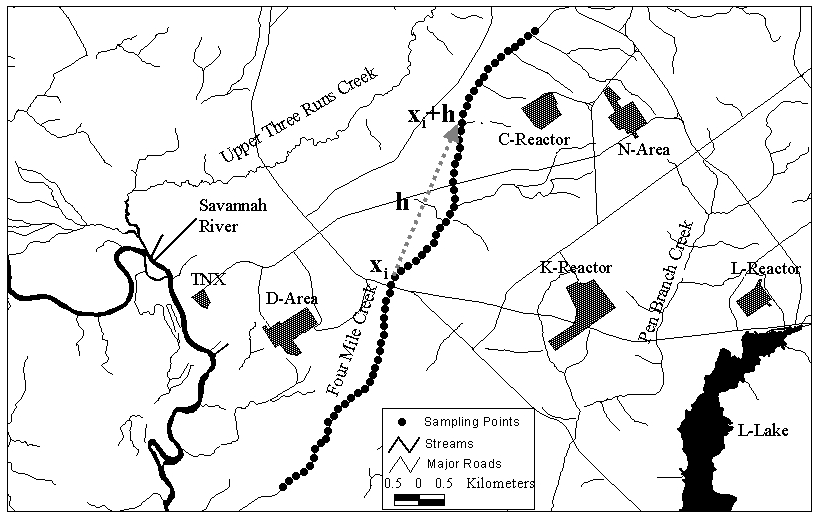
Figure 1
Figure 2
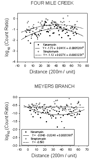
Figure 3
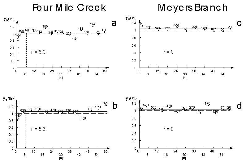
Figure 4
Figure 5